File:State border between Chop (USSR) and Čierna (Czechoslovakia) in 1985.jpg
Jump to navigation
Jump to search

Size of this preview: 800 × 535 pixels. Other resolutions: 320 × 214 pixels | 640 × 428 pixels | 1,024 × 685 pixels | 1,280 × 857 pixels | 1,711 × 1,145 pixels.
Original file (1,711 × 1,145 pixels, file size: 1.14 MB, MIME type: image/jpeg)
Captions
Captions
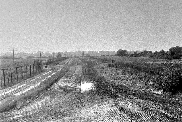
State border between Čierna nad Tisou (Czechoslovakia) and Chop (USSR) in 1985
Summary[edit]
_and_%C4%8Cierna_(Czechoslovakia)_in_1985.jpg&action=edit§ion=1)
| Description |
Čeština: Československo-sovětská státní hranice mezi Čiernou nad Tisou (Československo) a Čopem (Sovětský svaz) v roce 1985.
Deutsch: Staatsgrenze zwischen Čierna nad Tisou (Tschechoslowakei) und Tschop (Sowjetunion) im Jahre 1985.
Русский: Государственная граница между г. Чьерна-над-Тисоу (Чехословакия) и Чоп / Соломоново (СССР) в 1985 году, вид на юг. Контрольно-следовая полоса и сигнализационная система С-175 «Гардина». |
| Date | |
| Source | http://www.milovice.ru |
| Author | Anatoly Savin |
| Permission (Reusing this file) |
| Camera location | | View this and other nearby images on: OpenStreetMap |
|---|
_and_%C4%8Cierna_(Czechoslovakia)_in_1985.jpg¶ms=048.432859_N_0022.138445_E_globe:Earth_type:camera_heading:160.00&language=en)
Licensing[edit]
_and_%C4%8Cierna_(Czechoslovakia)_in_1985.jpg&action=edit§ion=2)
| This work has been released into the public domain by its author, Anatoly Savin. This applies worldwide. In some countries this may not be legally possible; if so: Anatoly Savin grants anyone the right to use this work for any purpose, without any conditions, unless such conditions are required by law.
|
| Annotations | This image is annotated: View the annotations at Commons |
_and_%C4%8Cierna_(Czechoslovakia)_in_1985.jpg)
File history
Click on a date/time to view the file as it appeared at that time.
| Date/Time | Thumbnail | Dimensions | User | Comment | |
|---|---|---|---|---|---|
| current | 18:13, 17 April 2020 | | 1,711 × 1,145 (1.14 MB) | Doronenko (talk | contribs) | enhanced |
| 07:53, 12 February 2007 |  | 1,711 × 1,145 (274 KB) | Doronenko (talk | contribs) | {{Information |Description=Czechoslovak-soviet state border between Čierna nad Tisou and Čop in 1985. |Source= |Date=1985 |Author=Anatoly Savin |Permission=yes |other_versions= }} Category:Čierna nad Tisou |
You cannot overwrite this file.
File usage on Commons
The following 2 pages use this file:
- Commons:Files used on OpenStreetMap/113
- File:Cierna-Cop.jpg (file redirect)
File usage on other wikis
The following other wikis use this file:
- Usage on cs.wikipedia.org
- Usage on da.wikipedia.org
- Usage on ru.wikipedia.org
- Usage on sk.wikipedia.org
_and_Čierna_(Czechoslovakia)_in_1985.jpg&oldid=559823617)