File:Stanley.falklands.war.svg
Jump to navigation
Jump to search

Size of this PNG preview of this SVG file: 800 × 397 pixels. Other resolutions: 320 × 159 pixels | 640 × 317 pixels | 1,024 × 508 pixels | 1,280 × 634 pixels | 2,560 × 1,269 pixels | 928 × 460 pixels.
Original file (SVG file, nominally 928 × 460 pixels, file size: 247 KB)
Captions
Captions
Add a one-line explanation of what this file represents

Summary[edit]
| Description |
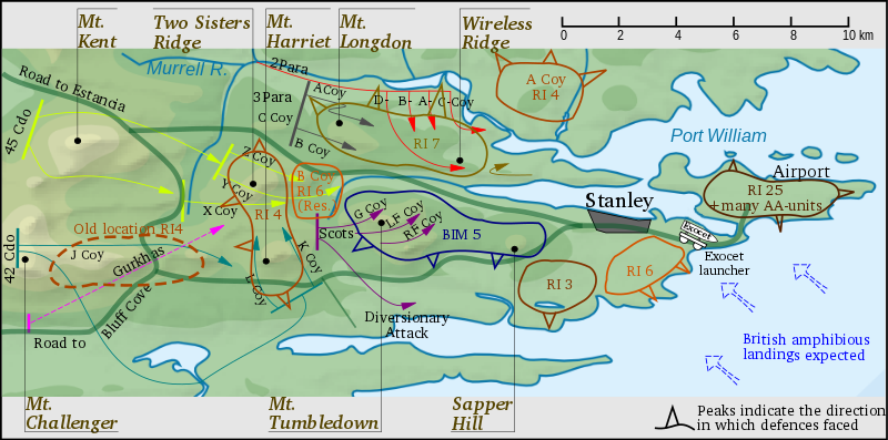
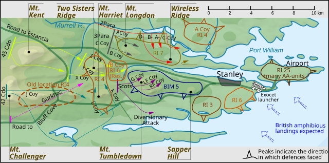
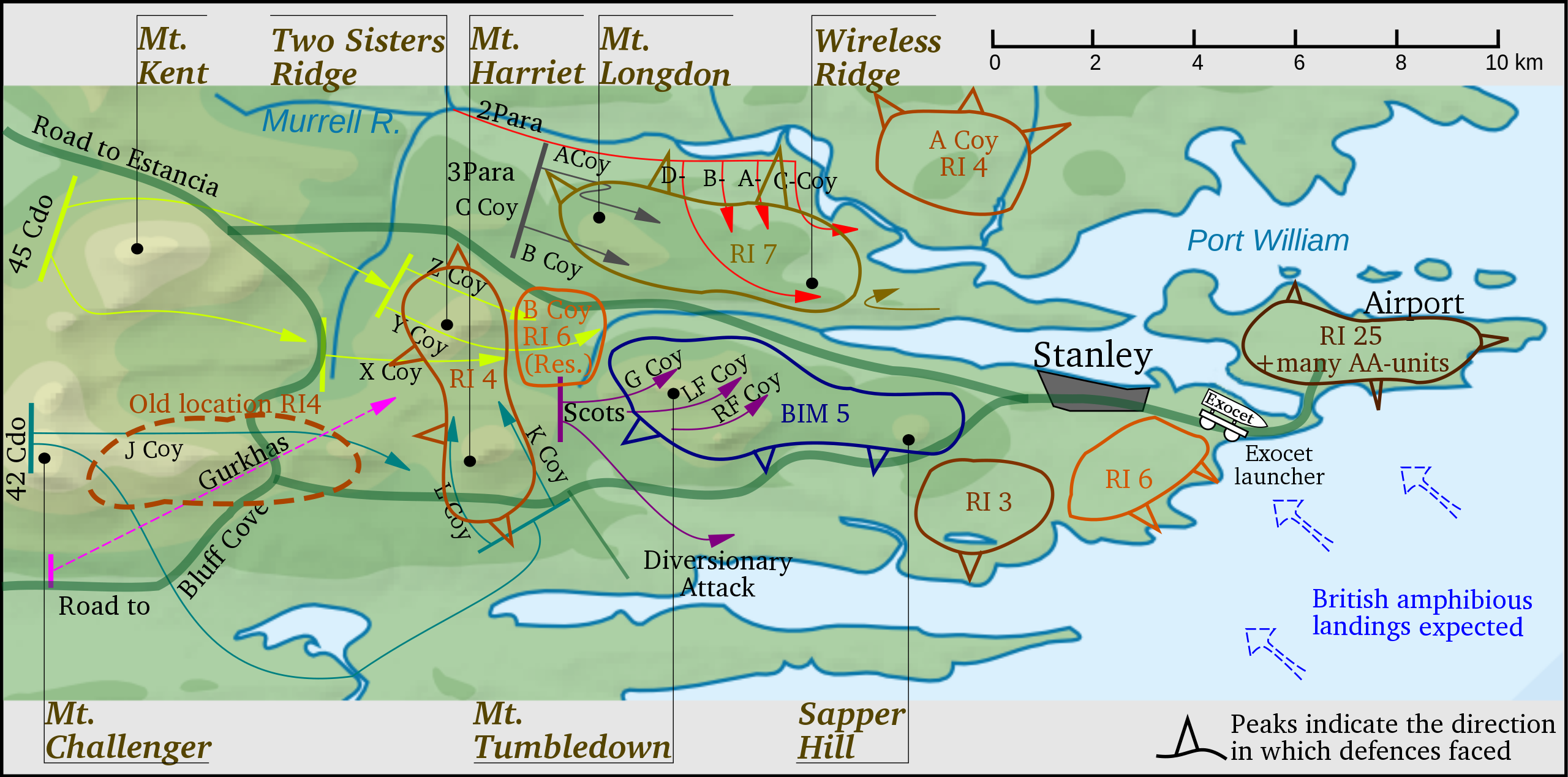
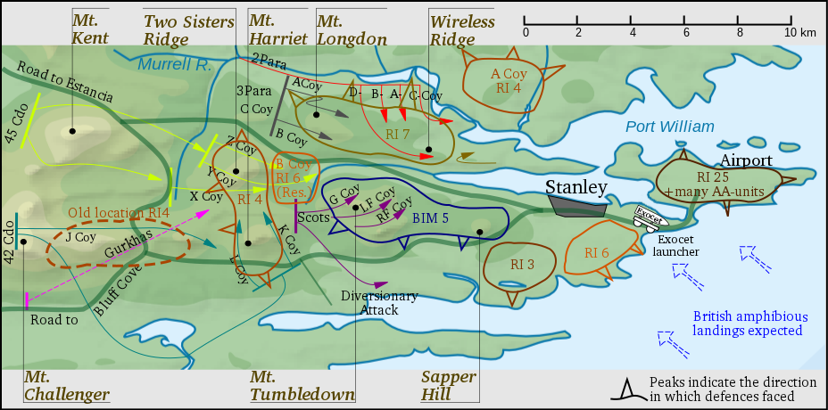
English: derivative of File:Falkland Islands topographic map-en.svg of Eric Gaba (Sting - fr:Sting) |
| Date | |
| Source | Own work and File:Falkland Islands topographic map-en.svg of Eric Gaba (Sting - fr:Sting) |
| Author | Createaccount |
content according http://www.naval-history.net/NAVAL1982FALKLANDS.htm (retrieved 07.10.2010)
Licensing[edit]
I, the copyright holder of this work, hereby publish it under the following licenses:
This file is licensed under the Creative Commons Attribution-Share Alike 3.0 Unported license.
- You are free:
- to share – to copy, distribute and transmit the work
- to remix – to adapt the work
- Under the following conditions:
- attribution – You must give appropriate credit, provide a link to the license, and indicate if changes were made. You may do so in any reasonable manner, but not in any way that suggests the licensor endorses you or your use.
- share alike – If you remix, transform, or build upon the material, you must distribute your contributions under the same or compatible license as the original.

|
Permission is granted to copy, distribute and/or modify this document under the terms of the GNU Free Documentation License, Version 1.2 or any later version published by the Free Software Foundation; with no Invariant Sections, no Front-Cover Texts, and no Back-Cover Texts. A copy of the license is included in the section entitled GNU Free Documentation License. |
You may select the license of your choice.
File history
Click on a date/time to view the file as it appeared at that time.
| Date/Time | Thumbnail | Dimensions | User | Comment | |
|---|---|---|---|---|---|
| current | 14:54, 29 December 2011 | | 928 × 460 (247 KB) | Keysanger (talk | contribs) | Road line now thicker |
| 17:04, 15 October 2010 |  | 928 × 460 (247 KB) | Keysanger (talk | contribs) | Exocet launcher added | |
| 11:09, 14 October 2010 |  | 928 × 460 (241 KB) | Keysanger (talk | contribs) | a curve shows the limits of every Argentine Regiment sector. Mt. Williams, Mt. Wall, bridge, "remannts" deleted | |
| 18:29, 11 October 2010 |  | 928 × 460 (226 KB) | Keysanger (talk | contribs) | * use a more cartographic colour (is it?) * Two Sisters Ridge * use original names RI4, RI7,etc * add a "+" before remmants * only one isthmus | |
| 12:16, 11 October 2010 |  | 929 × 521 (236 KB) | Keysanger (talk | contribs) | keep cool ... | |
| 12:14, 11 October 2010 |  | 929 × 521 (85 KB) | Keysanger (talk | contribs) | defence division lines deleted, | |
| 11:12, 9 October 2010 |  | 929 × 521 (250 KB) | Keysanger (talk | contribs) | mountain names out of map thinner paths line cover 58°W difuse border replaced | |
| 16:11, 8 October 2010 |  | 936 × 439 (236 KB) | Keysanger (talk | contribs) | no problem | |
| 16:07, 8 October 2010 |  | 936 × 549 (233 KB) | Keysanger (talk | contribs) | keep cool ... | |
| 16:04, 8 October 2010 |  | 936 × 528 (233 KB) | Keysanger (talk | contribs) | margin shortened |
You cannot overwrite this file.
File usage on Commons
The following page uses this file:
File usage on other wikis
The following other wikis use this file:
- Usage on da.wikipedia.org
- Usage on en.wikipedia.org
- Usage on no.wikipedia.org
- Usage on ro.wikipedia.org