File:St Joseph Michigan aerial view.jpg
Jump to navigation
Jump to search

Size of this preview: 800 × 558 pixels. Other resolutions: 320 × 223 pixels | 640 × 447 pixels | 1,024 × 715 pixels | 1,280 × 893 pixels | 1,500 × 1,047 pixels.
Original file (1,500 × 1,047 pixels, file size: 618 KB, MIME type: image/jpeg)
Captions
Captions
Add a one-line explanation of what this file represents
|
This is an image of a place or building that is listed on the National Register of Historic Places in the United States of America. Its reference number is 5001211. |
| Description |
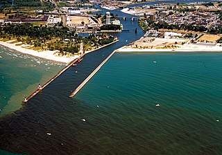
English: The shore and river outlet at St. Joseph, Michigan, USA. The St. Joseph River flows into Lake Michigan through the city of the same name. |
|||
| Date | not specified or unknown; predates 2000 | |||
| Source |
U.S. Army Corps of Engineers Digital Visual Library Image page: Archive link Image description page: Archive link Digital Visual Library home page |
|||
| Author | U.S. Army Corps of Engineers, photographer not specified or unknown | |||
| Permission (Reusing this file) |
|
|||
| Location | St. Joseph, Berrien County, Michigan, USA |
| Camera location | | View this and other nearby images on: OpenStreetMap |
|---|


File history
Click on a date/time to view the file as it appeared at that time.
| Date/Time | Thumbnail | Dimensions | User | Comment | |
|---|---|---|---|---|---|
| current | 03:14, 30 March 2007 | | 1,500 × 1,047 (618 KB) | DanMS (talk | contribs) | {{Information | Description = {{en|The shore and river outlet at St. Joseph, Michigan, USA. The St. Joseph River flows into Lake Michigan through the city of the same name.}} | Source = U.S. Army Corps of Engineers Digital Visual Library<br />[ |
You cannot overwrite this file.
File usage on Commons
The following 5 pages use this file:
File usage on other wikis
The following other wikis use this file:
- Usage on ar.wikipedia.org
- Usage on arz.wikipedia.org
- Usage on ceb.wikipedia.org
- Usage on ce.wikipedia.org
- Usage on cy.wikipedia.org
- Usage on dag.wikipedia.org
- Usage on de.wikipedia.org
- Usage on en.wikipedia.org
- Usage on en.wikivoyage.org
- Usage on es.wikipedia.org
- Usage on eu.wikipedia.org
- Usage on fr.wikipedia.org
- Usage on hu.wikipedia.org
- Usage on it.wikipedia.org
- Usage on lld.wikipedia.org
- Usage on pl.wikipedia.org
- Usage on pt.wikipedia.org
- Usage on ro.wikipedia.org
- Usage on ru.wikipedia.org
- Usage on sr.wikipedia.org
- Usage on sv.wikipedia.org
- Usage on tt.wikipedia.org
- Usage on uk.wikipedia.org
- Usage on uz.wikipedia.org
- Usage on www.wikidata.org
- Usage on zh-min-nan.wikipedia.org
- Usage on zh.wikipedia.org