File:Special member state territories and the European Union.svg
Jump to navigation
Jump to search

Size of this PNG preview of this SVG file: 512 × 258 pixels. Other resolutions: 320 × 161 pixels | 640 × 323 pixels | 1,024 × 516 pixels | 1,280 × 645 pixels | 2,560 × 1,290 pixels.
Original file (SVG file, nominally 512 × 258 pixels, file size: 835 KB)
Captions
Captions
Add a one-line explanation of what this file represents
Summary[edit]
| Description |
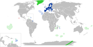
English:
European Union
Outermost regions
Overseas countries and territories
Special cases
Other special territories Français : Union européenne
Régions ultrapériphériques
Pays et territoires d'outre-mer
Cas spéciaux
Autres territoires spéciaux |
| Date | |
| Source | Own work |
| Author | Glentamara |
| SVG development |
Licensing[edit]
| I, the copyright holder of this work, release this work into the public domain. This applies worldwide. In some countries this may not be legally possible; if so: I grant anyone the right to use this work for any purpose, without any conditions, unless such conditions are required by law. |
File history
Click on a date/time to view the file as it appeared at that time.
| Date/Time | Thumbnail | Dimensions | User | Comment | |
|---|---|---|---|---|---|
| current | 19:12, 8 June 2022 | | 512 × 258 (835 KB) | Nablicus (talk | contribs) | new version |
| 10:13, 17 July 2020 |  | 512 × 259 (736 KB) | Alcaios (talk | contribs) | fixed – those were models I use to check the scale | |
| 23:03, 16 July 2020 |  | 512 × 258 (672 KB) | Nablicus (talk | contribs) | Reverted to version as of 19:08, 16 July 2020 (UTC). There is an extra UK and Iceland in the middle of Canada... | |
| 19:53, 16 July 2020 |  | 512 × 259 (753 KB) | Alcaios (talk | contribs) | frame | |
| 19:50, 16 July 2020 |  | 512 × 258 (681 KB) | Alcaios (talk | contribs) | minor fixed on Greenland mar. zone | |
| 19:46, 16 July 2020 |  | 512 × 258 (681 KB) | Alcaios (talk | contribs) | Added maritime zone of Gree,land based on https://www.marineregions.org/eezdetails.php?mrgid=8438 | |
| 19:32, 16 July 2020 |  | 512 × 259 (752 KB) | Alcaios (talk | contribs) | added Faroe Islands' maritime zone | |
| 19:08, 16 July 2020 |  | 512 × 258 (672 KB) | Alcaios (talk | contribs) | Maritime zones in the eastern Caribbean at the right scale, with the help of https://commons.wikimedia.org/wiki/File:Caribbean_maritime_boundaries_map.svg | |
| 18:44, 16 July 2020 |  | 512 × 259 (742 KB) | Alcaios (talk | contribs) | slight realignments | |
| 18:38, 16 July 2020 |  | 512 × 259 (742 KB) | Alcaios (talk | contribs) | typo in previous edit, read: "Northern Cyprus is not a special member state territory since..." –– the Åland archipelago is larger and almost reaches the Finnish coast |
You cannot overwrite this file.
File usage on Commons
The following 6 pages use this file:
.svg)
File usage on other wikis
The following other wikis use this file:
- Usage on ar.wikipedia.org
- Usage on br.wikipedia.org
- Usage on cs.wikipedia.org
- Usage on de.wikipedia.org
- Usage on en.wikipedia.org
- European Union
- Neocolonialism
- Outline of the European Union
- Special territories of members of the European Economic Area
- Potential enlargement of the European Union
- External border of the European Union
- User:Xicomaia/sandbox
- User:Spinykitsune65/sandbox2
- User:A diehard editor/sandbox/EU infobox
- User:Falcaorib/World Alliances
- Usage on fa.wikipedia.org
- Usage on fr.wikipedia.org
- Aruba
- Ceuta
- Polynésie française
- Groenland
- Açores
- Saint-Pierre-et-Miquelon
- Îles Canaries
- Madère
- Îles Kerguelen
- Île Clipperton
- Îles Féroé
- Région ultrapériphérique
- Îles Éparses de l'océan Indien
- Curaçao
- Åland
- Melilla
- Archipel Crozet
- Terre Adélie
- Bonaire
- Saba
- Saint-Eustache (Antilles)
- Peñón de Vélez de la Gomera
- Peñón de Alhucemas
- Îles Saint-Paul et Amsterdam
- Plazas de soberanía
- Nouvelle-Calédonie
- Saint-Martin (royaume des Pays-Bas)
- Saint-Martin (Antilles françaises)
- Pays et territoire d'outre-mer
- Saint-Barthélemy (Antilles françaises)
- Union européenne
- États membres de l'Union européenne
- Terres australes et antarctiques françaises
View more global usage of this file.