File:SpaghettiJunctionGA.jpg
Jump to navigation
Jump to search

Size of this preview: 800 × 527 pixels. Other resolutions: 320 × 211 pixels | 640 × 421 pixels | 992 × 653 pixels.
Original file (992 × 653 pixels, file size: 129 KB, MIME type: image/jpeg)
Captions
Captions
Add a one-line explanation of what this file represents
| Camera location | | View this and other nearby images on: OpenStreetMap |
|---|
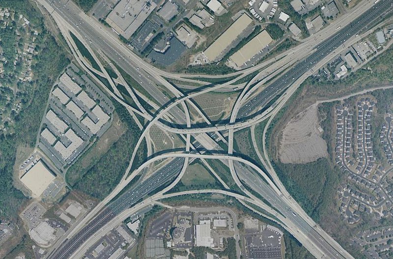
Tom Moreland Interchange, a.k.a. Spaghetti Junction, intersection of Interstate 85 and Interstate 285, just northeast of Atlanta, Georgia, USA. Latitude 33.89221, Longitude -84.25964. Aerial view from USGS "Urban Areas" image database. Composed using NASA World Wind.
This image is in the public domain in the United States because it only contains materials that originally came from the United States Geological Survey, an agency of the United States Department of the Interior. For more information, see the official USGS copyright policy.
|
File history
Click on a date/time to view the file as it appeared at that time.
| Date/Time | Thumbnail | Dimensions | User | Comment | |
|---|---|---|---|---|---|
| current | 09:16, 20 March 2005 | | 992 × 653 (129 KB) | Ray Spalding (talk | contribs) | Spaghetti Junction, GA {{PD-USGov-Interior-USGS}} |
You cannot overwrite this file.
File usage on Commons
The following page uses this file:
File usage on other wikis
The following other wikis use this file:
- Usage on br.wikipedia.org
- Usage on de.wikipedia.org
- Usage on en.wikipedia.org
- Usage on hu.wikipedia.org
- Usage on nl.wikipedia.org
- Usage on sk.wikipedia.org
- Usage on sl.wikipedia.org
- Usage on tr.wikipedia.org
- Usage on zh.wikipedia.org
Categories:
- Interstate 285 (Georgia)
- Interstate 85 in DeKalb County, Georgia
- Road bridges in Georgia (U.S. state)
- Overpass bridges in Georgia (U.S. state)
- 1980s bridges in Georgia (U.S. state)
- Aerial photographs of Georgia (U.S. state)
- Interchanges in Georgia (U.S. state)
- Aerial photographs of interchanges in the United States
- Stack interchanges
- NASA World Wind
- Bridges in DeKalb County, Georgia
- Things named after spaghetti