File:Spa Road station map 1872.png
Jump to navigation
Jump to search
No higher resolution available.
Spa_Road_station_map_1872.png (380 × 492 pixels, file size: 169 KB, MIME type: image/png)
Captions
Captions
Add a one-line explanation of what this file represents
Summary[edit]
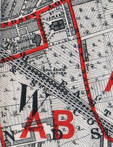
| Description | Map of the area around Spa Road railway station, London | |||||||||||||||||||
| Date | ||||||||||||||||||||
| Source | The School-Board Map of London | |||||||||||||||||||
| Author |
|
|||||||||||||||||||
Licensing[edit]
|
This work is in the public domain in its country of origin and other countries and areas where the copyright term is the author's life plus 100 years or fewer. | |
| This file has been identified as being free of known restrictions under copyright law, including all related and neighboring rights. | |
File history
Click on a date/time to view the file as it appeared at that time.
| Date/Time | Thumbnail | Dimensions | User | Comment | |
|---|---|---|---|---|---|
| current | 00:56, 27 January 2012 | | 380 × 492 (169 KB) | Prioryman (talk | contribs) | {{Information |Description=Map of the area around Spa Road railway station, London |Source=The School-Board Map of London |Date=1872 |Author=Edward Stanford |Permission= |other_versions= }} Category:Maps of Southwark |
You cannot overwrite this file.
File usage on Commons
There are no pages that use this file.
File usage on other wikis
The following other wikis use this file:
- Usage on en.wikipedia.org