File:Southern Washington Cascades conductor.png
Jump to navigation
Jump to search
Size of this preview: 429 × 600 pixels. Other resolutions: 171 × 240 pixels | 472 × 660 pixels.
Original file (472 × 660 pixels, file size: 81 KB, MIME type: image/png)
Captions
Captions
Add a one-line explanation of what this file represents
Summary[edit]
| Description |
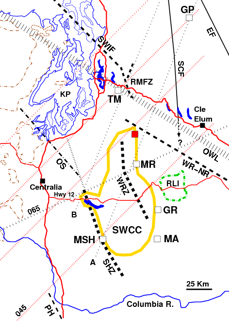
English: The Southern Washington Cascades Conductor (SWCC, yellow) located at depth approximately between Mount Saint Helens (MSH), Mount Adams (MA), Goat Rocks (GR), Mount Rainier (MR), and Riffe Lake, with a lobe extending towards Tiger Mountain (TM). MSH and MR are associated with bends and offsets in the seismically active Saint Helens Zone (SHZ) and Western Rainier Zone (WRZ)(thick dashed lines); these bends align with other volcanic features and with a fault at Glacier Peak (GP). The southern portions of the SHZ and WRZ are parallel with a regional orientation of faulting (including the Entiat Fault and Portland Hills fault zone). The w:Straight Creek Fault (inactive) shows 90 km of mid-Eocene right-lateral offset; its southern continuation is unknown. Line "B" marks a boundary in seismic activity.
Also shown: Southern Whidbey Island Fault, Rattlesnake Mountain Fault Zone, w:Olympic-Wallowa Lineament (OWL), White River/Naches River fault, Rimrock Lake Inlier (outlined in green), surface outcrops of the Crescent Formation (outlined in brown), and the Olympia Structure (suspected fault, aseismic). Red square is the White River altered area. |
| Date | |
| Source | Own work |
| Author | J. Johnson |
| Permission (Reusing this file) |
This file is licensed under the Creative Commons Attribution 3.0 Unported license.
|
Licensing[edit]
I, the copyright holder of this work, hereby publish it under the following licenses:
This file is licensed under the Creative Commons Attribution-Share Alike 3.0 Unported license.
- You are free:
- to share – to copy, distribute and transmit the work
- to remix – to adapt the work
- Under the following conditions:
- attribution – You must give appropriate credit, provide a link to the license, and indicate if changes were made. You may do so in any reasonable manner, but not in any way that suggests the licensor endorses you or your use.
- share alike – If you remix, transform, or build upon the material, you must distribute your contributions under the same or compatible license as the original.

|
Permission is granted to copy, distribute and/or modify this document under the terms of the GNU Free Documentation License, Version 1.2 or any later version published by the Free Software Foundation; with no Invariant Sections, no Front-Cover Texts, and no Back-Cover Texts. A copy of the license is included in the section entitled GNU Free Documentation License. |
You may select the license of your choice.
File history
Click on a date/time to view the file as it appeared at that time.
| Date/Time | Thumbnail | Dimensions | User | Comment | |
|---|---|---|---|---|---|
| current | 23:08, 16 January 2013 | | 472 × 660 (81 KB) | J. Johnson (talk | contribs) | Clarified some aspects of RMFZ, adjusted OWL. |
| 00:19, 18 January 2012 |  | 470 × 660 (81 KB) | J. Johnson (talk | contribs) | Refined position of some lines, extended RMFZ per DGER 2011-1 (Dragovich, et al.), added Cle Elum. | |
| 21:35, 14 April 2011 |  | 468 × 660 (47 KB) | J. Johnson (talk | contribs) | Added N45E bearing lineaments, minor adjustments and tightening of locations. | |
| 00:38, 11 March 2011 |  | 467 × 665 (27 KB) | J. Johnson (talk | contribs) | {{Information |Description ={{en|1=The Southern Washington Cascades Conductor (SWCC, yellow) located at depth approximately between Mount Saint Helens (MSH), Mount Adams (MA), Goat Rocks (GR), Mount Rainier (MR), and Riffe Lake, with a lobe extending t |
You cannot overwrite this file.
File usage on Commons
There are no pages that use this file.
File usage on other wikis
The following other wikis use this file:
- Usage on de.wikipedia.org
- Usage on en.wikipedia.org