File:Southern Airways Flight 49.png
Jump to navigation
Jump to search

Size of this preview: 422 × 599 pixels. Other resolutions: 169 × 240 pixels | 472 × 670 pixels.
Original file (472 × 670 pixels, file size: 247 KB, MIME type: image/png)
Captions
Captions
Add a one-line explanation of what this file represents
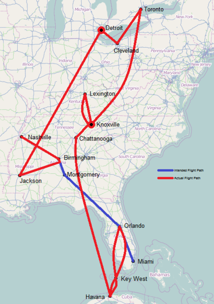
| Description | The flight path of Southern Airways Flight 49, which was hijacked in 1972. | |||
| Date | ||||
| Source | Map from OpenStreetMap, route drawn from [1] | |||
| Author | Own work (with map data from OpenStreetMap) | |||
| Permission (Reusing this file) |
This file is licensed under the Creative Commons Attribution-Share Alike 2.0 Generic license.
|
![[1]](http://www.microkhan.com/wp-content/uploads/2013/06/Route-of-Southern-Airways-Flight-49.jpg)
File history
Click on a date/time to view the file as it appeared at that time.
| Date/Time | Thumbnail | Dimensions | User | Comment | |
|---|---|---|---|---|---|
| current | 04:15, 18 July 2014 | | 472 × 670 (247 KB) | Image2012 (talk | contribs) | {{Information |Description=The flight path of Southern Airways Flight 49, which was hijacked in 1972. |Source=Map from OpenStreetMap, route drawn from [http://www.microkhan.com/wp-content/uploads/2013/06/Route-of-Southern-Airways-Flight-49.jpg] |Date=2... |
You cannot overwrite this file.
File usage on Commons
There are no pages that use this file.
File usage on other wikis
The following other wikis use this file:
- Usage on fr.wikipedia.org