File:Southeast asia.svg
Jump to navigation
Jump to search

Size of this PNG preview of this SVG file: 506 × 598 pixels. Other resolutions: 203 × 240 pixels | 406 × 480 pixels | 650 × 768 pixels | 866 × 1,024 pixels | 1,733 × 2,048 pixels.
Original file (SVG file, nominally 506 × 598 pixels, file size: 729 KB)
Captions
Captions
Add a one-line explanation of what this file represents
Summary[edit]
| Description |
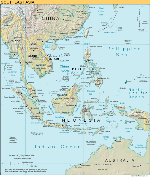
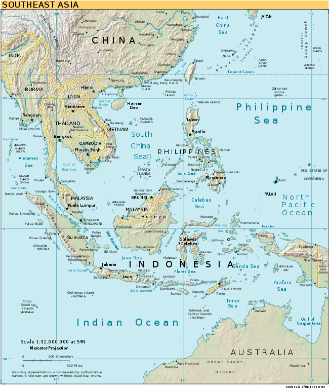
English: Southeast Asia |
| Source | CIA World Factbook converted in SVG |
| Author | |
| Other versions |
[]
|
| SVG development |


Licensing[edit]
This image is in the public domain because it contains materials that originally came from the United States Central Intelligence Agency's World Factbook.
|
 |
File history
Click on a date/time to view the file as it appeared at that time.
| Date/Time | Thumbnail | Dimensions | User | Comment | |
|---|---|---|---|---|---|
| current | 17:02, 17 May 2018 | | 506 × 598 (729 KB) | Glrx (talk | contribs) | guess image/jpeg |
| 18:04, 24 January 2006 |  | 506 × 598 (729 KB) | Moyogo (talk | contribs) | stripping useless stuff | |
| 20:21, 23 January 2006 |  | 506 × 598 (1.04 MB) | Sanao (talk | contribs) | Southeast Asia<br /> Origin : CIA World Factbook converted in SVG Category:SVG maps Category:Southeast Asia |
You cannot overwrite this file.
File usage on Commons
The following 6 pages use this file:
File usage on other wikis
The following other wikis use this file:
- Usage on ar.wikipedia.org
- Usage on da.wikipedia.org
- Usage on en.wikipedia.org
- Southeast Asia
- Talk:Jemaah Islamiyah
- Talk:Slow loris
- Talk:Selenocosmia
- Talk:Neriene
- Talk:Amyciaea
- Talk:Achaearanea
- Talk:Episinus
- Talk:Argyrodes
- Talk:Meta (spider)
- Talk:Asemonea
- Talk:Augustaea
- Talk:Bocus
- Talk:Burmattus
- Talk:Chrysilla
- Talk:Chinattus
- Talk:Chalcotropis
- Talk:Chalcoscirtus
- Talk:Ceglusa
- Talk:Carrhotus
- Talk:Canama
- Talk:Copocrossa
- Talk:Colyttus
- Talk:Cocalus (spider)
- Talk:Cocalodes
- Talk:Diplocanthopoda
- Talk:Euophrys
- Talk:Ergane (spider)
- Talk:Epocilla
- Talk:Epidelaxia
- Talk:Gelotia
- Talk:Marengo (spider)
- Talk:Mantisatta
- Talk:Magyarus
- Talk:Mintonia
- Talk:Menemerus
- Talk:Mendoza (spider)
- Talk:Neobrettus
- Talk:Nannenus
- Talk:Orthrus (spider)
- Talk:Orsima
- Talk:Onomastus
- Talk:Nungia
- Talk:Panysinus
- Talk:Pancorius
- Talk:Philates
- Talk:Phintella
- Talk:Phlegra (spider)
View more global usage of this file.