File:Southafricafire oli 20240131 lrg.jpg
Jump to navigation
Jump to search

Size of this preview: 800 × 533 pixels. Other resolutions: 320 × 213 pixels | 640 × 427 pixels | 1,024 × 683 pixels | 1,280 × 853 pixels | 2,560 × 1,706 pixels | 3,143 × 2,095 pixels.
Original file (3,143 × 2,095 pixels, file size: 2.49 MB, MIME type: image/jpeg)
Captions
Captions
Add a one-line explanation of what this file represents
Summary[edit]
| Description |
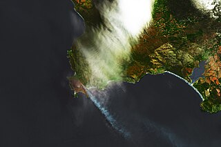
English: Landsat 8 false-color image of a fire burning near Pringle Bay and Betty’s Bay in South Africa’s Western Cape province on January 31, 2024. NASA Earth Observatory Image of the Day for February 3, 2024 |
| Date | |
| Source | https://earthobservatory.nasa.gov/images/152400/fire-chars-pringle-bay |
| Author | NASA Earth Observatory image by Lauren Dauphin, using Landsat data from the U.S. Geological Survey. |
Licensing[edit]
| This file is in the public domain in the United States because it was solely created by NASA. NASA copyright policy states that "NASA material is not protected by copyright unless noted". (See Template:PD-USGov, NASA copyright policy page or JPL Image Use Policy.) | ||
 |
Warnings:
|
File history
Click on a date/time to view the file as it appeared at that time.
| Date/Time | Thumbnail | Dimensions | User | Comment | |
|---|---|---|---|---|---|
| current | 09:42, 3 February 2024 | | 3,143 × 2,095 (2.49 MB) | Lupe (talk | contribs) | Uploaded a work by NASA Earth Observatory image by Lauren Dauphin, using Landsat data from the U.S. Geological Survey. from https://earthobservatory.nasa.gov/images/152400/fire-chars-pringle-bay with UploadWizard |
You cannot overwrite this file.
File usage on Commons
The following page uses this file: