File:South Shetland Islands Map.png
Jump to navigation
Jump to search
Size of this preview: 800 × 551 pixels. Other resolutions: 320 × 220 pixels | 640 × 441 pixels | 1,103 × 760 pixels.
Original file (1,103 × 760 pixels, file size: 35 KB, MIME type: image/png)
Captions
Captions
Add a one-line explanation of what this file represents
| Description |
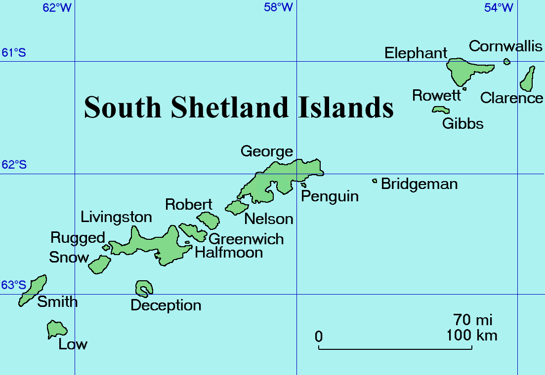
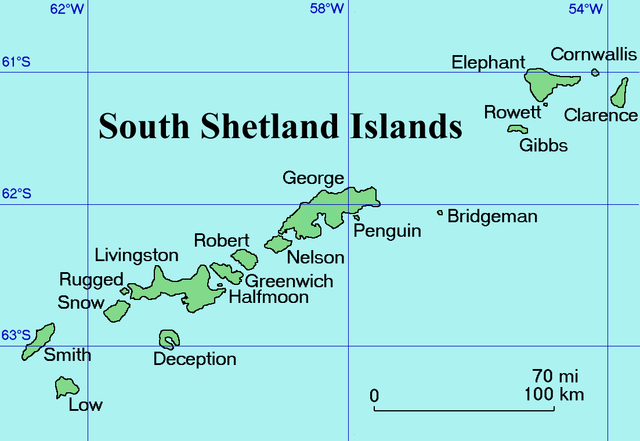
English: Map of the South Shetland Islands
Català: Mapa de les illes Shetland del Sud.
Deutsch: Karte der Südlichen Shetlandinseln
Español: Mapa de las Islas Shetland del Sur
Italiano: Una mappa delle Isole Shetland Meridionali
Русский: Карта Южных Шетландских островов (английский вариант)
Slovenščina: Zemljevid otočja |
| Date | Commons upload by Snowdog |
| Source |
Originally from en.wikipedia; description page is (was) here
|
| Author | User Topbanana on en.wikipedia |
| Permission (Reusing this file) |
PD-self |
| |
This work has been released into the public domain by its author, Topbanana, at the English Wikipedia project. This applies worldwide. In case this is not legally possible: |
File history
Click on a date/time to view the file as it appeared at that time.
| Date/Time | Thumbnail | Dimensions | User | Comment | |
|---|---|---|---|---|---|
| current | 20:11, 27 February 2005 | | 1,103 × 760 (35 KB) | Snowdog (talk | contribs) | Map of the South Shetland Islands |
You cannot overwrite this file.
File usage on Commons
The following 12 pages use this file:
- Atlas of Antarctica
- Template:South Shetland Islandsyear
- Category:1993 in the South Shetland Islands
- Category:1994 in the South Shetland Islands
- Category:1997 in the South Shetland Islands
- Category:2003 in the South Shetland Islands
- Category:2004 in the South Shetland Islands
- Category:Bridgeman Island
- Category:Maps of the South Shetland Islands
- Category:Mountains of the South Shetland Islands
- Category:Penguin Island (South Shetland Islands)
- Category:South Shetland Islands
File usage on other wikis
The following other wikis use this file:
- Usage on af.wikipedia.org
- Usage on ang.wikipedia.org
- Usage on ar.wikipedia.org
- Usage on ast.wikipedia.org
- Usage on az.wikipedia.org
- Usage on ba.wikipedia.org
- Usage on be.wikipedia.org
- Usage on bg.wikipedia.org
- Usage on br.wikipedia.org
- Usage on ca.wikipedia.org
- Usage on ceb.wikipedia.org
- Usage on ce.wikipedia.org
- Usage on cs.wikipedia.org
- Usage on cv.wikipedia.org
- Usage on da.wikipedia.org
- Usage on de.wikipedia.org
- Usage on el.wikipedia.org
- Usage on en.wikipedia.org
- South Shetland Islands
- Gibbs Island (South Shetland Islands)
- Clarence Island (South Shetland Islands)
- Cornwallis Island (South Shetland Islands)
- Seal Islands (South Shetland Islands)
- Benjamin Morrell
- Endurance Point
- Cape Bowles
- Chinstrap Cove
- Walker Point
- Jubilee Peak
- Sultan Glacier
- Furness Glacier
- Gnomon Island
- Cape Lloyd
- Highton Glacier
- Ravelin Ridge
- Cape Valentine
- Wordie Seamount
View more global usage of this file.