File:Sodus Point - 20200611 - 02.jpg
Jump to navigation
Jump to search

Size of this preview: 800 × 191 pixels. Other resolutions: 320 × 76 pixels | 640 × 153 pixels | 1,024 × 245 pixels | 1,280 × 306 pixels | 2,560 × 612 pixels | 16,378 × 3,914 pixels.
Original file (16,378 × 3,914 pixels, file size: 17.06 MB, MIME type: image/jpeg)
Captions
Captions
Add a one-line explanation of what this file represents
Summary[edit]
| Description |
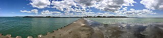
English: Panoramic view from near the base of Sodus Outer Light looking back toward shore, June 2020. From left to right you can see: the cliffs at Chimney Bluffs State Park, the cottage communities at Crescent Beach and Charles Point with the east breakwater below them, the town center and Greig Street business district, the west breakwall, the beach, and the Lake Ontario shore west of town. |
| Date | |
| Source | Own work |
| Author | AndreCarrotflower |
| Camera location | | View this and other nearby images on: OpenStreetMap |
|---|
Licensing[edit]
I, the copyright holder of this work, hereby publish it under the following license:
This file is licensed under the Creative Commons Attribution-Share Alike 4.0 International license.
- You are free:
- to share – to copy, distribute and transmit the work
- to remix – to adapt the work
- Under the following conditions:
- attribution – You must give appropriate credit, provide a link to the license, and indicate if changes were made. You may do so in any reasonable manner, but not in any way that suggests the licensor endorses you or your use.
- share alike – If you remix, transform, or build upon the material, you must distribute your contributions under the same or compatible license as the original.
File history
Click on a date/time to view the file as it appeared at that time.
| Date/Time | Thumbnail | Dimensions | User | Comment | |
|---|---|---|---|---|---|
| current | 16:37, 23 June 2020 | 16,378 × 3,914 (17.06 MB) | AndreCarrotflower (talk | contribs) | Uploaded own work with UploadWizard |
You cannot overwrite this file.
File usage on Commons
There are no pages that use this file.