File:Smoke and Fire in Eastern Asia (MODIS 2022-04-21).jpg

Original file (5,144 × 4,326 pixels, file size: 1.97 MB, MIME type: image/jpeg)
Captions
Captions
Summary[edit]
.jpg&action=edit§ion=1)
| Description |
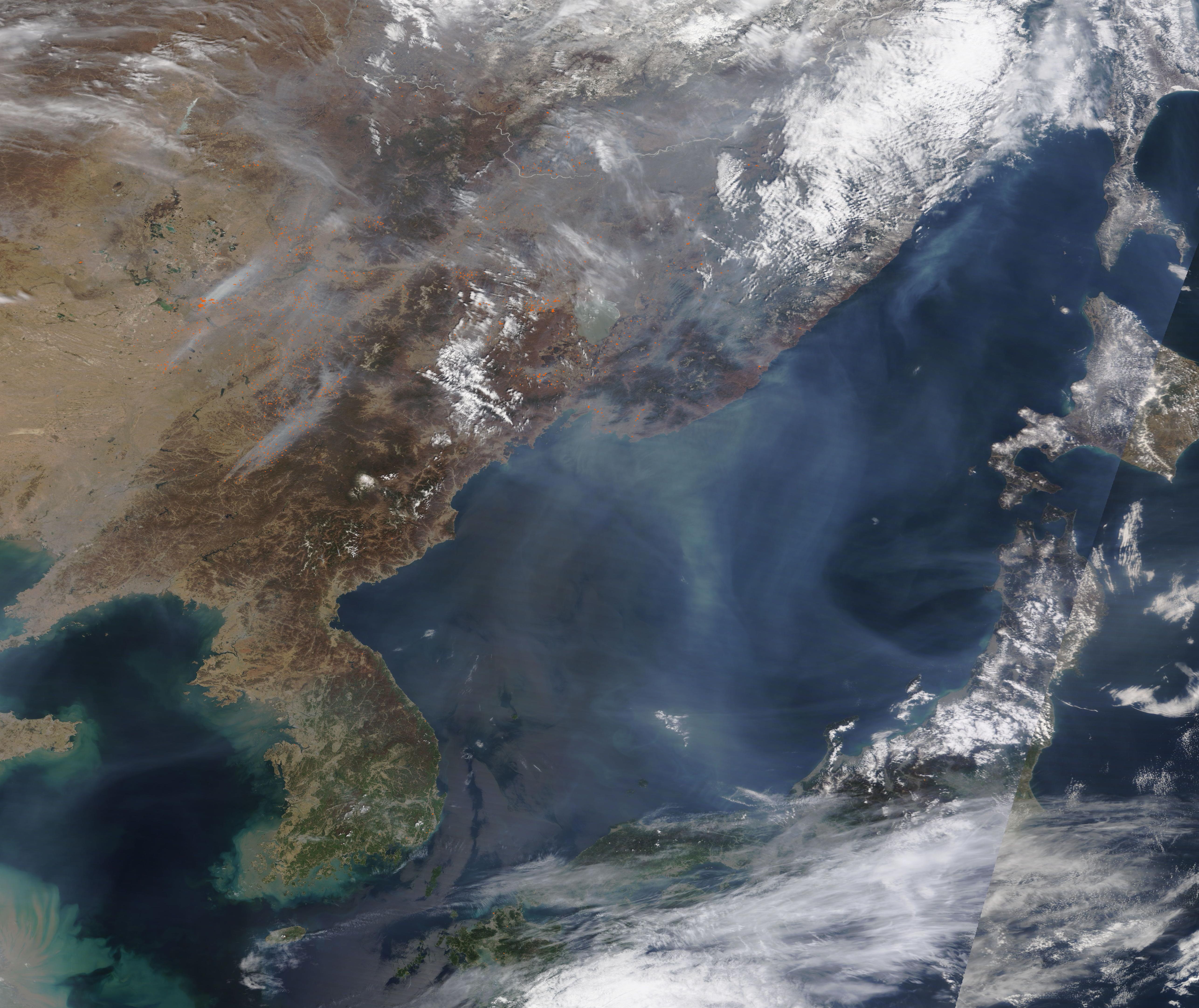
English: Hundreds of fires were burning in Eastern Asia in mid-April 2022, emitting so much smoke that much of the region was covered under a pale gray haze. The Moderate Resolution Imaging Spectroradiometer (MODIS) on board NASA’s Terra satellite acquired this true-color image of the smoky scene on April 19.
Each red “hot spot” marks an area where the thermal bands on the MODIS instrument detected high temperatures. When combined with typical smoke, as in this image, such hot spots are diagnostic for actively burning fire. Although it is not possible to determine the cause of an individual fire from satellite imagery, the location, high number, and time of year strongly suggests these fires are agricultural in nature and were deliberately set to manage land. That doesn’t mean that all of the fires are used to clear land, burn stubble, renew pasture, or prepare fields for planting. At least one wildfire has been reported in China over the last week, and poorly managed agricultural fires may become wildfires. Most of the fires are spread across Northeastern China, with some clusters in southeastern Russia near the border with China. On the Korean Peninsula, only a few fires were seen in either North Korea or South Korea. Northeastern China is a rich agricultural region, located on a fertile black-earth belt, and has been called “China’s granary” because it produces more than a fifth of China’s grain output. Major crops include soybeans, corn, and japonica rice. Spring planting typically takes place by late April in Northeast China, but planting has been difficult this spring. Fertilizer and fuel costs have risen steeply recently, and some areas are under strict restrictions due to COVID. Outbreaks in the Jilin region, for example, triggered lockdowns that prevented plowing and planting until at least April 5, when some farmers could return to work as long as they produced negative COVID tests. Jilin is China’s second-largest corn producing region. In addition, in response to health and climate concerns related to widespread agricultural burning, China has instituted anti-pollution rules that target stubble burning, demanding that farmers stop using fire and start using machines to clear the fields. To small farmers, machine-clearing a field is both expensive and difficult, so they often continue to use the tried-and-true traditional methods of using fire to prepare land ahead of sowing the season’s crops. |
||
| Date | Taken on 19 April 2022 | ||
| Source |
Smoke and Fire in Eastern Asia (direct link)
|
||
| Author | MODIS Land Rapid Response Team, NASA GSFC |
| This media is a product of the Terra mission Credit and attribution belongs to the mission team, if not already specified in the "author" row |
Licensing[edit]
.jpg&action=edit§ion=2)
| This file is in the public domain in the United States because it was solely created by NASA. NASA copyright policy states that "NASA material is not protected by copyright unless noted". (See Template:PD-USGov, NASA copyright policy page or JPL Image Use Policy.) | ||
 |
Warnings:
|
File history
Click on a date/time to view the file as it appeared at that time.
| Date/Time | Thumbnail | Dimensions | User | Comment | |
|---|---|---|---|---|---|
| current | 22:07, 9 January 2024 | | 5,144 × 4,326 (1.97 MB) | OptimusPrimeBot (talk | contribs) | #Spacemedia - Upload of http://modis.gsfc.nasa.gov/gallery/images/image04212022_500m.jpg via Commons:Spacemedia |
You cannot overwrite this file.
File usage on Commons
There are no pages that use this file.
.jpg&oldid=840279352)