File:Skyline Drive - Map 3 - South District.jpg

Original file (4,440 × 6,653 pixels, file size: 7.94 MB, MIME type: image/jpeg)
Captions
Captions
Summary[edit]
| Description |
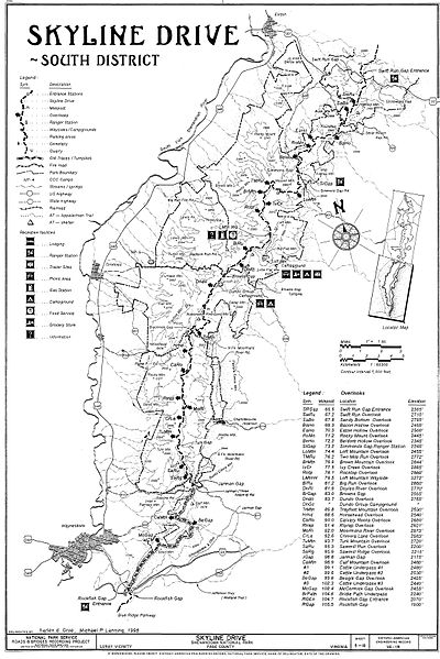
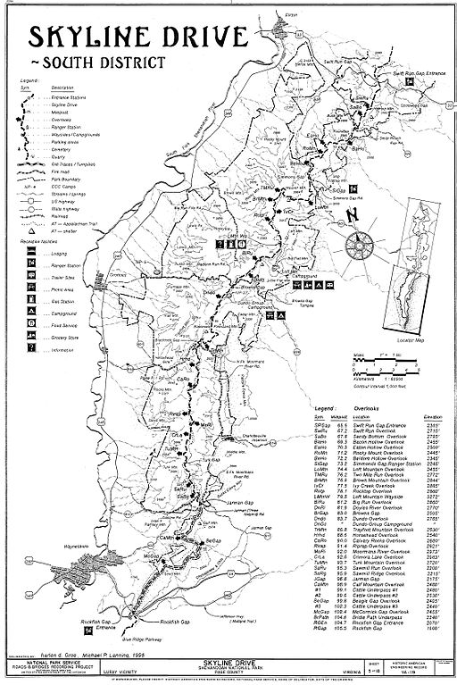
English: Skyline Drive, South District map — in the Blue Ridge Mountains from Swift Run Gap to Rockfish Gap (southern terminus).
Skyline Drive, From Front Royal, VA to Rockfish Gap, VA , Luray vicinity, Page County, VA. (Maps 1 - 3)
Measured Drawing(s): 18 (24 x 36) Photo(s): 117
HAER VA,70-LURA.V,4-
Documentation compiled after 1968.
Survey number HAER VA-119
Part of building/structure is in Front Royal, Warren County, VA. (for Map 1)
VIRGINIA--Page County--Luray vicinity (for Map 1)
Harvey, Robert R., delineator Groe, harlan d., delineator Lanning, Michael P., delineator Seeger, Christopher J., delineator Wirth, Shane P., delineator Faust, William A., photographer Schmell, Brant, delineator Stokes, Dave, delineator Lundquist, Ryan, delineator Reproduction Number [See Call Number]
Historic American Engineering Record—HAER (Library of Congress)
Library of Congress, Prints and Photograph Division, Washington, D.C. 20540 USA DIGID http://hdl.loc.gov/loc.pnp/hhh.va1798 CARD # VA1798 |
| Date |
|
| Source | Transferred from en.wikipedia by SreeBot |
| Author | Daderot at en.wikipedia |
Licensing[edit]
| This image or media file contains material based on a work of a National Park Service employee, created as part of that person's official duties. As a work of the U.S. federal government, such work is in the public domain in the United States. See the NPS website and NPS copyright policy for more information. |
Original upload log[edit]
Upload date | User | Bytes | Dimensions | Comment
- 2006-05-15 21:17 (UTC) | Daderot | 8325336 (bytes) | 4440×6653 | Skyline Drive map - South District. This map is cropped from a drawing in the Library of Congress online collection; see catalog information below. It is in the public domain because it was produced by the United States Government. Item Title Skyline Dr
File history
Click on a date/time to view the file as it appeared at that time.
| Date/Time | Thumbnail | Dimensions | User | Comment | |
|---|---|---|---|---|---|
| current | 09:32, 29 August 2011 | | 4,440 × 6,653 (7.94 MB) | SreeBot (talk | contribs) |
You cannot overwrite this file.
File usage on Commons
There are no pages that use this file.
File usage on other wikis
The following other wikis use this file:
- Usage on en.wikipedia.org
Metadata
- Maps of Skyline Drive (Shenandoah National Park)
- Travel maps of Virginia
- Blue Ridge Mountains
- Augusta County, Virginia
- Skyline Drive in Greene County, Virginia
- Nelson County, Virginia
- Skyline Drive in Rockingham County, Virginia
- Historic American Engineering Record of Virginia - Drawings
- Historic American Engineering Record images of Virginia