File:Six Day War Territories.png
Six_Day_War_Territories.png (398 × 599 pixels, file size: 53 KB, MIME type: image/png)
Captions
Captions
Summary[edit]

|
File:Six Day War Terrritories.svg is a vector version of this file. It should be used in place of this PNG file when not inferior.
File:Six Day War Territories.png → File:Six Day War Terrritories.svg
For more information, see Help:SVG. |
 |
| Description |
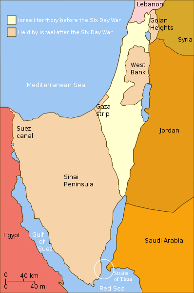
English: Changes in political boundaries following the Six Day war. In yellow: Israel within the "Green Line" borders (per 1949 ceasefire agreements); In light maroon: Territories Israel seized during the war and maintained its control over them in the aftermath of the war. The Straits of Tiran are circled, between the Gulf of Aqaba/Eilat, and the Red Sea. |
| Date | Unknown date |
| Source | Yom Kippur War map.svg |
| Author | User:Ling.Nut |
| Other versions |
[]
|


.png)


"Self-made line drawing of a map of Israel's territories before and after the Six Day War. Author: User:Ling.Nut Source of line drawing: File:Yom Kippur War map.svg authored by User:Raul654, sourced to now-deleted image Image:Jom kippur war.jpg, which was originally uploaded to the polish Wikipedia at http://pl.wikipedia.org/wiki/Grafika:Jom_kippur_war.jpg -- Ministerstwo Spraw Zagranicznych Izraela, za zgodÄ… Ambasady Izraela w Polsce. -- Ministry of Foreign Affairs of Israel, with the permission of Israel Embassy in Poland"
Licensing[edit]
- You are free:
- to share – to copy, distribute and transmit the work
- to remix – to adapt the work
- Under the following conditions:
- attribution – You must give appropriate credit, provide a link to the license, and indicate if changes were made. You may do so in any reasonable manner, but not in any way that suggests the licensor endorses you or your use.
- share alike – If you remix, transform, or build upon the material, you must distribute your contributions under the same or compatible license as the original.
File history
Click on a date/time to view the file as it appeared at that time.
| Date/Time | Thumbnail | Dimensions | User | Comment | |
|---|---|---|---|---|---|
| current | 21:32, 11 November 2010 | | 398 × 599 (53 KB) | 99of9 (talk | contribs) | Reverted to version as of 07:04, 25 July 2010. Both POV versions should be at different locations, marked with POV and linked. |
| 11:06, 8 November 2010 |  | 398 × 599 (52 KB) | Supreme Deliciousness (talk | contribs) | Israeli territory before the Six day war is the same as after the Six day war. | |
| 07:04, 25 July 2010 |  | 398 × 599 (53 KB) | Ling.Nut (talk | contribs) | {{Information |Description={{en|1=Israeli territories before and after the Six Day War. The Straits of Tiran are circled, between the Gulf of Aqaba, and the Red Sea.}} |Source=Yom Kippur War map.svg |Author=User:Ling.Nut |Date= |Permission= |other_ver |
You cannot overwrite this file.
File usage on Commons
The following 21 pages use this file:
- File:Kuuepäevane sõda.png
- File:Rhyfel chwe diwrnod map.png
- File:Six Day War Territories-ar.svg
- File:Six Day War Territories-de.svg
- File:Six Day War Territories-es.svg
- File:Six Day War Territories-fr.png
- File:Six Day War Territories-hu.svg
- File:Six Day War Territories-pl.svg
- File:Six Day War Territories-pt.svg
- File:Six Day War Territories-uk.svg
- File:Six Day War Territories.png
- File:Six Day War Territories.svg
- File:Six Day War Territories (hy).png
- File:Six Day War Territories - Tamil.png
- File:Six Day War Territories 2.png
- File:Six Day War Territories af.svg
- File:Six Day War Territories mk.svg
- File:Six Day War Territories ru.svg
- File:Six Day War Terrritories.png (file redirect)
- Template:Other versions/Six Day War Territories
File usage on other wikis
The following other wikis use this file:
- Usage on ca.wikipedia.org
- Usage on he.wikipedia.org
- Usage on nl.wikipedia.org
- Usage on ug.wikipedia.org
- Usage on www.wikidata.org