File:Sir Lowry's Pass, viewpoint.JPG
Jump to navigation
Jump to search

Size of this preview: 800 × 537 pixels. Other resolutions: 320 × 215 pixels | 640 × 430 pixels | 1,020 × 685 pixels.
Original file (1,020 × 685 pixels, file size: 222 KB, MIME type: image/jpeg)
Captions
Captions
Add a one-line explanation of what this file represents
Summary[edit]
| Description |
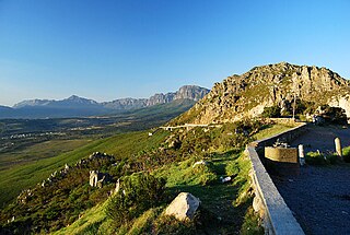
English: Sir Lowry's Pass is a mountain pass on the N2 national road in the Western Cape province of South Africa. It crosses the Hottentots-Holland mountain range between Somerset West and Grabouw on the main national road between Cape Town and the Garden Route. |
| Date | |
| Source | Own work |
| Author | Ossewa |
| Camera location | | View this and other nearby images on: OpenStreetMap |
|---|
Licensing[edit]
I, the copyright holder of this work, hereby publish it under the following license:
This file is licensed under the Creative Commons Attribution-Share Alike 3.0 Unported license.
- You are free:
- to share – to copy, distribute and transmit the work
- to remix – to adapt the work
- Under the following conditions:
- attribution – You must give appropriate credit, provide a link to the license, and indicate if changes were made. You may do so in any reasonable manner, but not in any way that suggests the licensor endorses you or your use.
- share alike – If you remix, transform, or build upon the material, you must distribute your contributions under the same or compatible license as the original.
File history
Click on a date/time to view the file as it appeared at that time.
| Date/Time | Thumbnail | Dimensions | User | Comment | |
|---|---|---|---|---|---|
| current | 12:15, 7 October 2012 | | 1,020 × 685 (222 KB) | Ossewa (talk | contribs) | User created page with UploadWizard |
You cannot overwrite this file.
File usage on Commons
There are no pages that use this file.