File:Siouxreservationmap.png
Jump to navigation
Jump to search
No higher resolution available.
Siouxreservationmap.png (500 × 500 pixels, file size: 259 KB, MIME type: image/png)
Captions
Captions
Add a one-line explanation of what this file represents
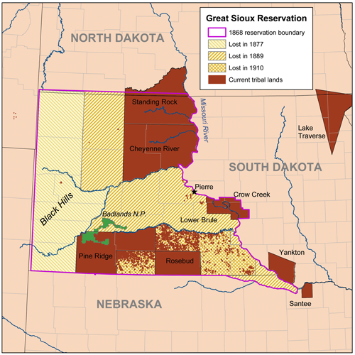
| Description | Map of the Great Sioux Reservation. |
| Date | |
| Source | self-made, using National Atlas data and original treaty descriptions. |
| Author | Kmusser |
| Other versions |
|


I, the copyright holder of this work, hereby publish it under the following license:
This file is licensed under the Creative Commons Attribution-Share Alike 2.5 Generic license.
- You are free:
- to share – to copy, distribute and transmit the work
- to remix – to adapt the work
- Under the following conditions:
- attribution – You must give appropriate credit, provide a link to the license, and indicate if changes were made. You may do so in any reasonable manner, but not in any way that suggests the licensor endorses you or your use.
- share alike – If you remix, transform, or build upon the material, you must distribute your contributions under the same or compatible license as the original.
File history
Click on a date/time to view the file as it appeared at that time.
| Date/Time | Thumbnail | Dimensions | User | Comment | |
|---|---|---|---|---|---|
| current | 14:50, 19 March 2008 | | 500 × 500 (259 KB) | Kmusser (talk | contribs) | Corrected southern border. |
| 19:08, 18 March 2008 |  | 500 × 500 (257 KB) | Kmusser (talk | contribs) | {{Information |Description=Map of the Great Sioux Reservation. |Source=self-made, using National Atlas data and original treaty descriptions. |Date=March 18, 2008 |Author= [[User: |
You cannot overwrite this file.
File usage on Commons
The following 2 pages use this file:
File usage on other wikis
The following other wikis use this file:
- Usage on ca.wikipedia.org
- Usage on cs.wikipedia.org
- Usage on de.wikipedia.org
- Usage on en.wikipedia.org
- Usage on it.wikipedia.org
- Usage on ja.wikipedia.org
- Usage on ko.wikipedia.org
- Usage on pt.wikipedia.org
- Usage on ro.wikipedia.org
- Usage on ru.wikipedia.org