File:Sikh Empire.JPG
Jump to navigation
Jump to search
Size of this preview: 732 × 599 pixels. Other resolutions: 293 × 240 pixels | 586 × 480 pixels.
Original file (800 × 655 pixels, file size: 251 KB, MIME type: image/jpeg)
Captions
Captions
Add a one-line explanation of what this file represents

|
This historical map image could be re-created using vector graphics as an SVG file. This has several advantages; see Commons:Media for cleanup for more information. If an SVG form of this image is available, please upload it and afterwards replace this template with
{{vector version available|new image name}}.
It is recommended to name the SVG file “Sikh Empire.svg”—then the template Vector version available (or Vva) does not need the new image name parameter. |


Summary[edit]
| Description |
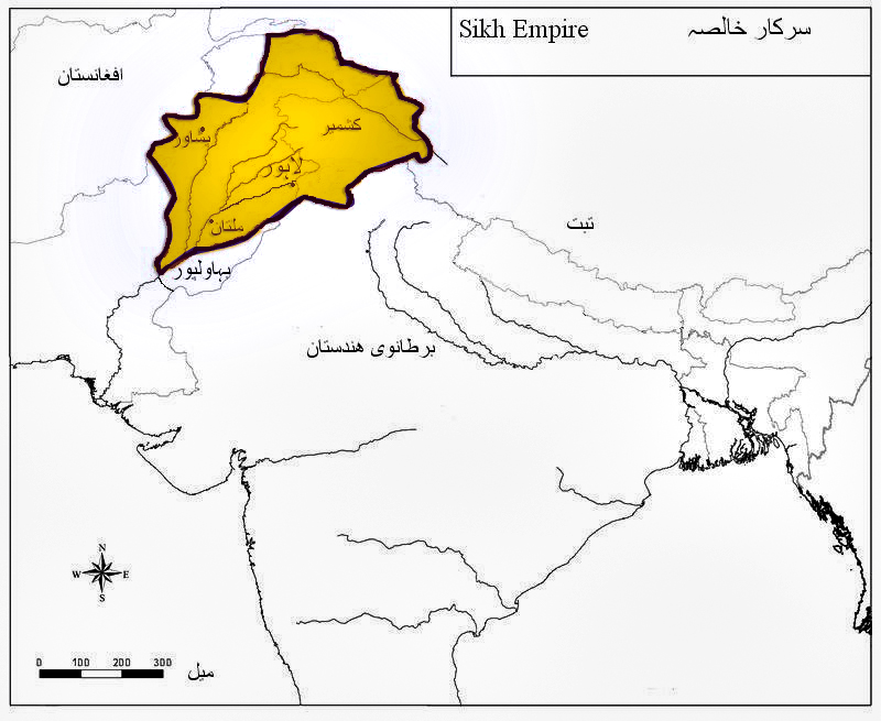
English: Boundaries of Maharaja Ranjit Singh |
| Date | |
| Source | Own work |
| Author | Khalid Mahmood |
Derivative works of this file:
Licensing[edit]
I, the copyright holder of this work, hereby publish it under the following licenses:
This file is licensed under the Creative Commons Attribution-Share Alike 3.0 Unported license.
- You are free:
- to share – to copy, distribute and transmit the work
- to remix – to adapt the work
- Under the following conditions:
- attribution – You must give appropriate credit, provide a link to the license, and indicate if changes were made. You may do so in any reasonable manner, but not in any way that suggests the licensor endorses you or your use.
- share alike – If you remix, transform, or build upon the material, you must distribute your contributions under the same or compatible license as the original.

|
Permission is granted to copy, distribute and/or modify this document under the terms of the GNU Free Documentation License, Version 1.2 or any later version published by the Free Software Foundation; with no Invariant Sections, no Front-Cover Texts, and no Back-Cover Texts. A copy of the license is included in the section entitled GNU Free Documentation License. |
You may select the license of your choice.
File history
Click on a date/time to view the file as it appeared at that time.
| Date/Time | Thumbnail | Dimensions | User | Comment | |
|---|---|---|---|---|---|
| current | 23:12, 26 December 2016 | | 800 × 655 (251 KB) | Jangvijay (talk | contribs) | Reverted to 15:56, 18 June 2015 (UTC) - separate File:Sikh Empire tri-lingual.JPG |
| 22:28, 25 December 2016 |  | 800 × 655 (131 KB) | Jangvijay (talk | contribs) | Added multi-lingual labels. Added more place names. | |
| 15:56, 18 June 2015 |  | 800 × 655 (251 KB) | Editorialix (talk | contribs) | Reverted to version as of 04:57, 2 September 2013 | |
| 15:55, 18 June 2015 |  | 800 × 655 (124 KB) | Editorialix (talk | contribs) | {{Information |Description={{es|1=Límites del Maharaja Ranjit Singh}} |Source={{versión}} |Author=Khalid Mahmood |Date=2015-06-18 |Permission= |other_versions=yes }} Category:Punyab | |
| 04:57, 2 September 2013 |  | 800 × 655 (251 KB) | Jujhar.pannu (talk | contribs) | Filled boundary area with colour. | |
| 09:04, 27 November 2010 |  | 800 × 655 (84 KB) | Khalid Mahmood (talk | contribs) | Correcting boundaries by adding Kapurthala and Hoshiarpur. | |
| 15:40, 9 May 2010 |  | 800 × 655 (52 KB) | Khalid Mahmood (talk | contribs) | {{Information |Description={{en|1=Boundaries of Maharaja Ranjit Singh}} |Source={{own}} |Author=Khalid Mahmood |Date=2010-05-09 |Permission= |other_versions=no }} Category:Punjab |
You cannot overwrite this file.
File usage on Commons
The following 5 pages use this file:
File usage on other wikis
The following other wikis use this file:
- Usage on ar.wikipedia.org
- Usage on ast.wikipedia.org
- Usage on az.wikipedia.org
- Usage on bn.wikipedia.org
- Usage on el.wikipedia.org
- Usage on en.wikipedia.org
- Usage on es.wikipedia.org
- Usage on fa.wikipedia.org
- Usage on gl.wikipedia.org
- Usage on hu.wikipedia.org
- Usage on hy.wikipedia.org
- Usage on incubator.wikimedia.org
- Usage on ko.wikipedia.org
- Usage on pnb.wikipedia.org
- Usage on ps.wikipedia.org
- Usage on ru.wikipedia.org
- Usage on sd.wikipedia.org
- Usage on simple.wikipedia.org
- Usage on si.wikipedia.org
- Usage on skr.wikipedia.org
- Usage on ta.wikipedia.org
- Usage on uk.wikipedia.org
- Usage on ur.wikipedia.org
- Usage on vi.wikipedia.org
- Usage on www.wikidata.org
- Usage on zh.wikipedia.org