File:Shakemap Earthquake 4 Jan 2016 India.jpg
Jump to navigation
Jump to search
Size of this preview: 511 × 600 pixels. Other resolutions: 204 × 240 pixels | 612 × 718 pixels.
Original file (612 × 718 pixels, file size: 147 KB, MIME type: image/jpeg)
Captions
Captions
Add a one-line explanation of what this file represents
Summary[edit]
| Description |
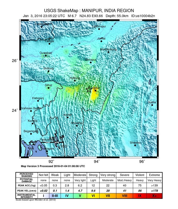
Deutsch: Karte des Erdbebens in Nordost-Indien (Manipur) im Januar 2016, mit Zentrum um die Stadt Imphal. English: 2016 Northeast India earthquake map with the affected City Imphal in Manipur. Español: Terremoto de India de 2016 |
| Date | |
| Source | https://earthquake.usgs.gov/earthquakes/eventpage/us10004b2n#impact_shakemap |
| Author | United States Geological Survey |
Licensing[edit]
This image is in the public domain in the United States because it only contains materials that originally came from the United States Geological Survey, an agency of the United States Department of the Interior. For more information, see the official USGS copyright policy.
|
File history
Click on a date/time to view the file as it appeared at that time.
| Date/Time | Thumbnail | Dimensions | User | Comment | |
|---|---|---|---|---|---|
| current | 19:53, 4 January 2016 | | 612 × 718 (147 KB) | Cacen Gymraeg (talk | contribs) | User created page with UploadWizard |
You cannot overwrite this file.
File usage on Commons
The following 2 pages use this file:
File usage on other wikis
The following other wikis use this file:
- Usage on es.wikipedia.org
- Usage on hr.wikipedia.org
- Usage on ko.wikipedia.org
- Usage on pt.wikipedia.org
- Usage on www.wikidata.org