File:Shake map of 2021 Majene earthquake.jpg
Jump to navigation
Jump to search
Size of this preview: 512 × 600 pixels. Other resolutions: 205 × 240 pixels | 612 × 717 pixels.
Original file (612 × 717 pixels, file size: 323 KB, MIME type: image/jpeg)
Captions
Captions
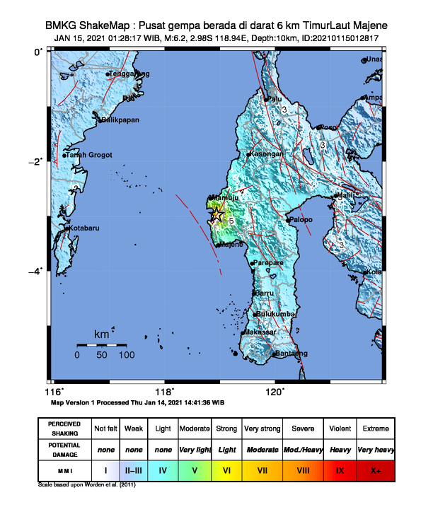
Shake map of 2021 West Sulawesi earthquake
Summary[edit]
| Description |
English: A map describing the intensity of the 2021 West Sulawesi earthquake |
| Date | |
| Source | https://twitter.com/infoBMKG/status/1349793574984925191/photo/1 |
| Author | Badan Meteorologi, Klimatologi dan Geofisika (BMKG) |
Licensing[edit]
| This file is in the public domain in Indonesia, because it is published and distributed by the Government of Republic of Indonesia, according to Article 43 of Law 28 of 2014 on copyrights.
There shall be no infringement of Copyright for:
|
 |
File history
Click on a date/time to view the file as it appeared at that time.
| Date/Time | Thumbnail | Dimensions | User | Comment | |
|---|---|---|---|---|---|
| current | 01:46, 15 January 2021 | | 612 × 717 (323 KB) | PaPa PaPaRoony (talk | contribs) | Uploaded a work by Badan Meteorologi, Klimatologi dan Geofisika (BMKG) from https://twitter.com/infoBMKG/status/1349793574984925191/photo/1 with UploadWizard |
You cannot overwrite this file.
File usage on Commons
The following page uses this file:
File usage on other wikis
The following other wikis use this file:
- Usage on ar.wikipedia.org
- Usage on es.wikipedia.org
- Usage on ms.wikipedia.org
- Usage on nl.wikipedia.org
- Usage on nl.wikinews.org
- Usage on pt.wikinews.org
- Usage on www.wikidata.org