File:Several wildfires raging in New Mexico.jpg

Original file (4,408 × 2,540 pixels, file size: 4.32 MB, MIME type: image/jpeg)
Captions
Captions
Summary[edit]
| Description |
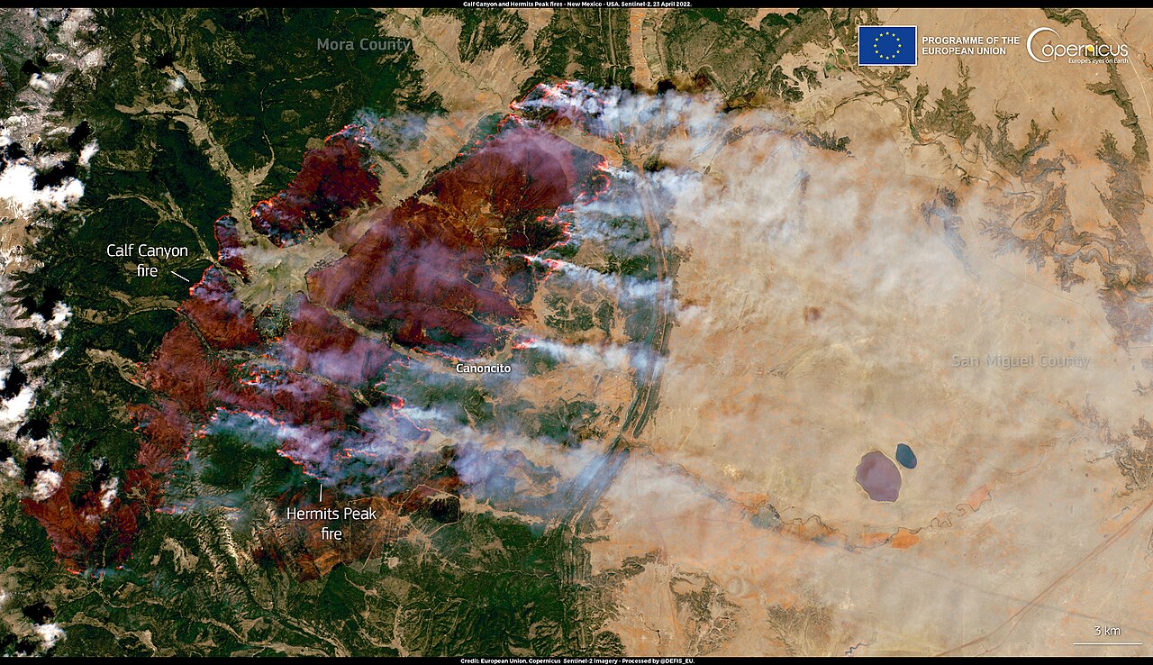
English: Multiple wildfires are currently burning across New Mexico, USA, with devastating consequences. Several communities have been evacuated, electric power has been proactively shut off and multiple roads have been closed to keep people in the area safe. Between Friday 22 and Saturday 23 April 2022, The governor of New Mexico declared a state of emergency for Colfax, Lincoln, San Miguel, Valencia, and Mora counties to make funding and state resources available for communities battling the ongoing wildfires. This image, acquired by one of the Copernicus Sentinel-2 satellites on Saturday 23 April 2022, shows the Calf Canyon and the Hermits Peak Fires, which are mainly affecting the communities of San Miguel and Mora. The two fires had started independently, but the strong winds and low humidity levels in the area caused them to merge and spread through dry vegetation in Northern New Mexico on Friday 22 April. The overall burnt area, which is visible in the image, stands at approximately 17,000 hectares. Thanks to their high frequency of acquisition, Copernicus Sentinel-2 satellite data are an important source of valuable information, which can be used to monitor the vegetation status and contribute to the assessment of the consequences of a wildfire event. |
| Date | Taken on 23 April 2022 |
| Source | Several wildfires raging in New Mexico |
| Author | European Union, Copernicus Sentinel-2 imagery |
Licensing[edit]

|
This image contains data from a satellite in the Copernicus Programme, such as Sentinel-1, Sentinel-2 or Sentinel-3. Attribution is required when using this image.
Attribution: Contains modified Copernicus Sentinel data 2022
The use of Copernicus Sentinel Data is regulated under EU law (Commission Delegated Regulation (EU) No 1159/2013 and Regulation (EU) No 377/2014). Relevant excerpts:
Free access shall be given to GMES dedicated data [...] made available through GMES dissemination platforms [...].
Access to GMES dedicated data [...] shall be given for the purpose of the following use in so far as it is lawful:
GMES dedicated data [...] may be used worldwide without limitations in time.
GMES dedicated data and GMES service information are provided to users without any express or implied warranty, including as regards quality and suitability for any purpose. |
File history
Click on a date/time to view the file as it appeared at that time.
| Date/Time | Thumbnail | Dimensions | User | Comment | |
|---|---|---|---|---|---|
| current | 00:07, 19 August 2023 | | 4,408 × 2,540 (4.32 MB) | OptimusPrimeBot (talk | contribs) | #Spacemedia - Upload of https://www.copernicus.eu/system/files/2022-04/image_day/20220425_WildfiresNewMexico.jpg via Commons:Spacemedia |
You cannot overwrite this file.
File usage on Commons
There are no pages that use this file.