File:Seto Inland Sea satellite.jpg
Jump to navigation
Jump to search

Size of this preview: 800 × 544 pixels. Other resolutions: 320 × 218 pixels | 640 × 435 pixels | 1,024 × 696 pixels.
Original file (1,024 × 696 pixels, file size: 242 KB, MIME type: image/jpeg)
Captions
Captions
Add a one-line explanation of what this file represents
| Description |
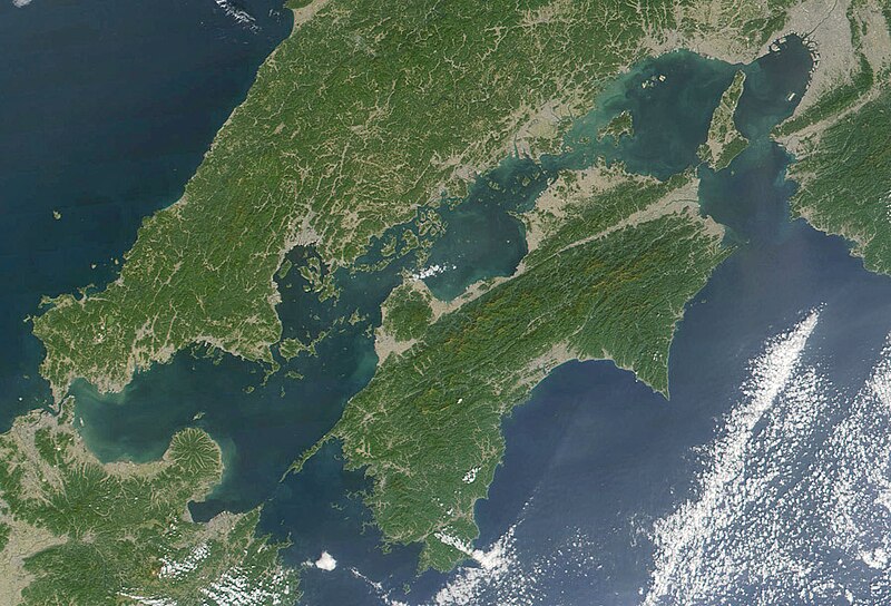
日本語: 瀬戸内海 Seto-naikai
Deutsch: Die Seto-Inlandsee ist ein Binnenmeer das die japanischen Inseln Honshū, Shikoku und Kyūshū voneinander trennt.
English: Formally named the Seto Inland Sea, the Inland Sea is the body of water separating Honshū, Shikoku, two of the main islands of Japan, and Kyūshū. |
| Date | |
| Source | Cropped from: http://visibleearth.nasa.gov/view_rec.php?id=2206 |
| Author | Jacques Descloitres, MODIS Land Rapid Response Team, NASA/GSFC |
| This file is in the public domain in the United States because it was solely created by NASA. NASA copyright policy states that "NASA material is not protected by copyright unless noted". (See Template:PD-USGov, NASA copyright policy page or JPL Image Use Policy.) | ||
 |
Warnings:
|
File history
Click on a date/time to view the file as it appeared at that time.
| Date/Time | Thumbnail | Dimensions | User | Comment | |
|---|---|---|---|---|---|
| current | 21:21, 22 November 2004 | | 1,024 × 696 (242 KB) | Tsui (talk | contribs) | Japan, the Seto inland-lake |
You cannot overwrite this file.
File usage on Commons
The following 2 pages use this file:
- Seto-naikai
- File:Seto Inland-Lake.jpg (file redirect)
File usage on other wikis
The following other wikis use this file:
- Usage on en.wikipedia.org
- Usage on fr.wikipedia.org
- Usage on it.wikivoyage.org
- Usage on ja.wikipedia.org
- Usage on ja.wikibooks.org
- Usage on ko.wikipedia.org
- Usage on pl.wiktionary.org
- Usage on tr.wikipedia.org
- Usage on www.wikidata.org
- Usage on wuu.wikipedia.org
- Usage on zh-classical.wikipedia.org
- Usage on zh-min-nan.wikipedia.org
- Usage on zh.wikipedia.org
- 瀨戶內海
- 四國
- 日本島嶼列表
- User:Liangent-adminbot/CleanupILH-page
- Wikipedia:优良条目/2017年5月
- Talk:四國
- Wikipedia:优良条目/四國
- Wikipedia:优良条目/2017年5月17日
- Wikipedia:典范条目/2017年8月
- Wikipedia:典范条目/四國
- Wikipedia:典范条目/2017年8月31日
- Wikipedia:典范条目/2020年3月
- Wikipedia:典范条目/2020年3月31日
- User:Vanished user 5843yqigtbih4q5g98q5ojih/大後天首頁
- Wikipedia:典范条目/2024年5月
- Wikipedia:典范条目/2024年5月3日