File:Scotland topographic map-ru.svg
Jump to navigation
Jump to search

Size of this PNG preview of this SVG file: 417 × 599 pixels. Other resolutions: 167 × 240 pixels | 334 × 480 pixels | 534 × 768 pixels | 712 × 1,024 pixels | 1,425 × 2,048 pixels | 2,400 × 3,450 pixels.
Original file (SVG file, nominally 2,400 × 3,450 pixels, file size: 5.53 MB)
Captions
Captions
Add a one-line explanation of what this file represents
Summary[edit]
| Camera location | | View this and other nearby images on: OpenStreetMap |
|---|
| Description |
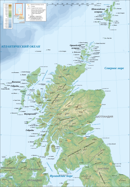
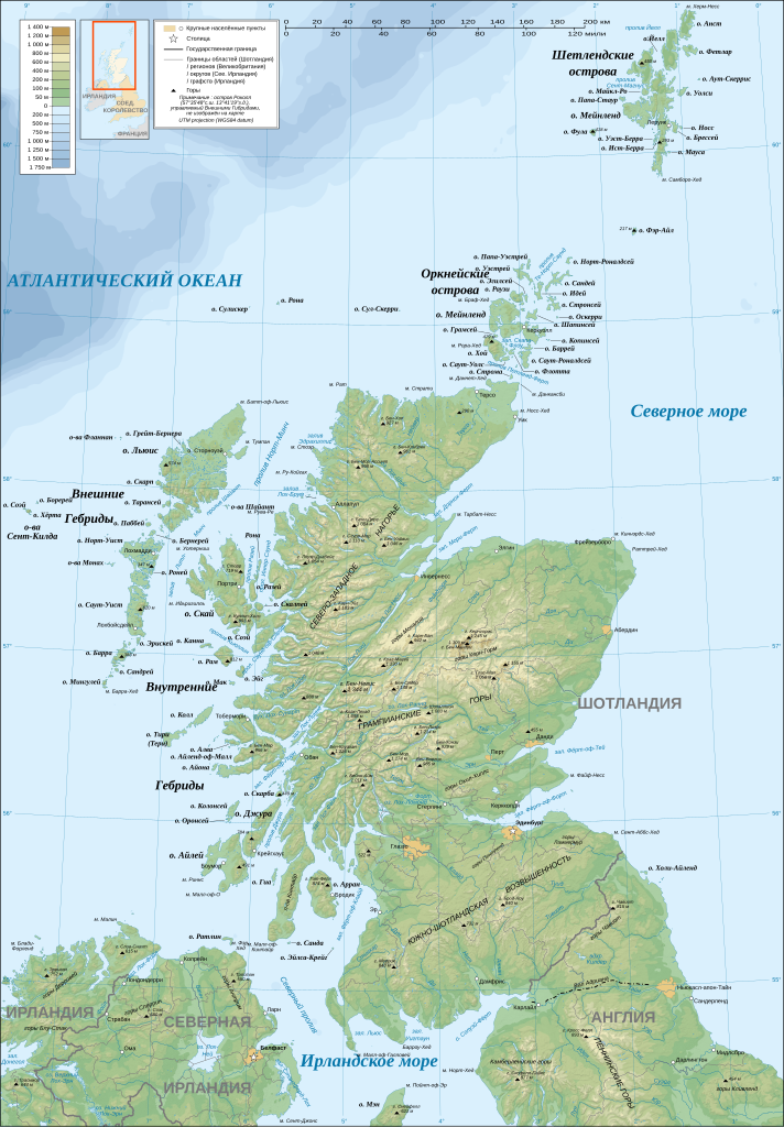
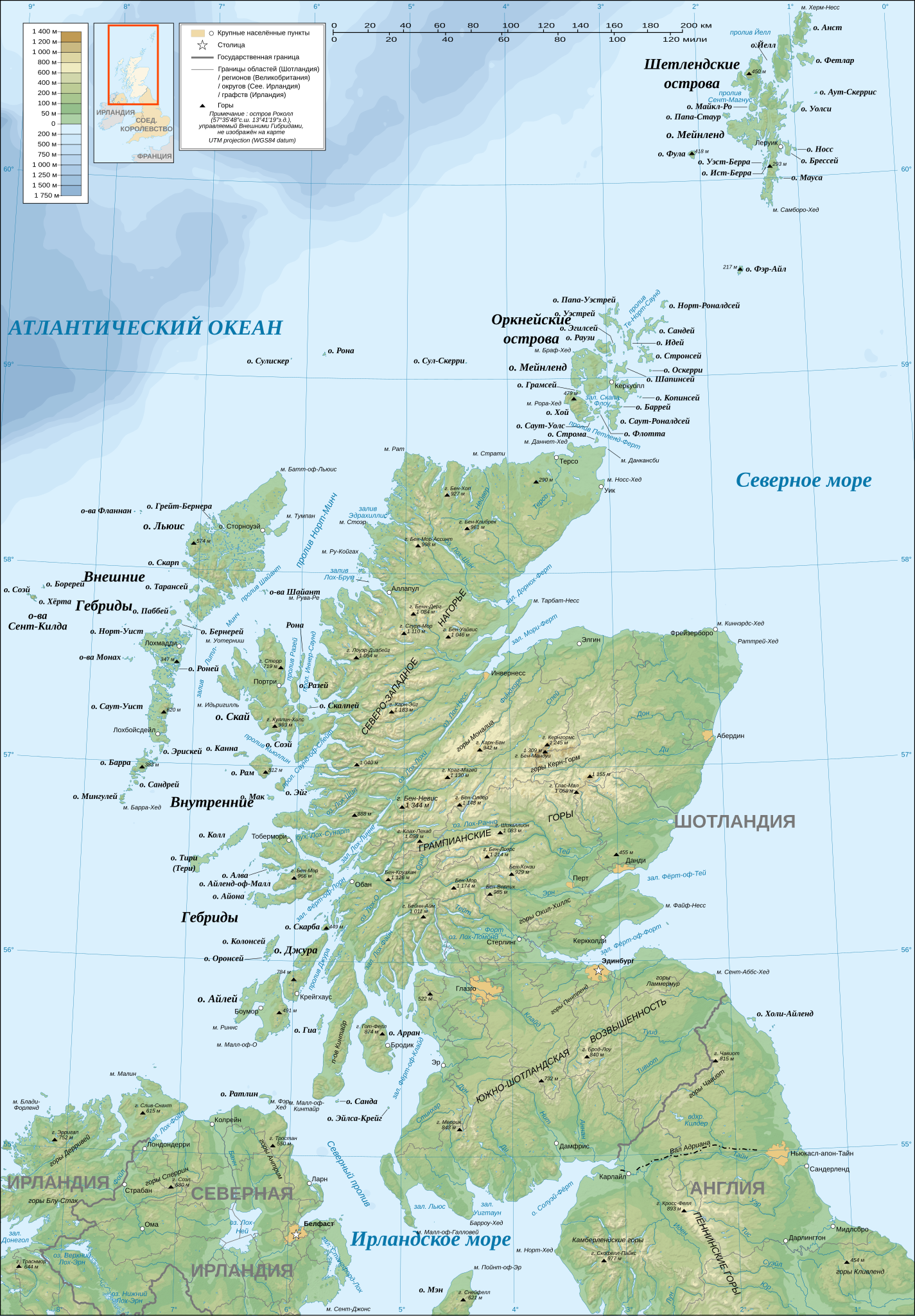
English: Topographic map in Russian of Scotland.
Note: The background map is a raster image embedded in the SVG file. Русский: Топографическая карта на русском языке Шотландии.
Примечание : Фоновая карта представляет собой растровый рисунок, вставленный в SVG-файл.
|
| Date | December 2007 (modified 04/2009) |
| Source |
Own work ;
|
| Author | Eric Gaba (Sting - fr:Sting). Translation: Переход Артур - ru:Переход Артур |
| Permission (Reusing this file) |
Attribution and Share-Alike required |
| Other versions |
[]
|


|
This SVG file contains embedded text that can be translated into your language, using any capable SVG editor, text editor or the SVG Translate tool. For more information see: About translating SVG files. |
Licensing[edit]
Eric Gaba and Переход Артур, the copyright holder of this work, hereby publishes it under the following licenses:

|
Permission is granted to copy, distribute and/or modify this document under the terms of the GNU Free Documentation License, Version 1.2 or any later version published by the Free Software Foundation; with no Invariant Sections, no Front-Cover Texts, and no Back-Cover Texts. A copy of the license is included in the section entitled GNU Free Documentation License. |
This file is licensed under the Creative Commons Attribution-Share Alike 4.0 International, 3.0 Unported, 2.5 Generic, 2.0 Generic and 1.0 Generic license.
Attribution: Eric Gaba and Переход Артур
- You are free:
- to share – to copy, distribute and transmit the work
- to remix – to adapt the work
- Under the following conditions:
- attribution – You must give appropriate credit, provide a link to the license, and indicate if changes were made. You may do so in any reasonable manner, but not in any way that suggests the licensor endorses you or your use.
- share alike – If you remix, transform, or build upon the material, you must distribute your contributions under the same or compatible license as the original.
You may select the license of your choice.
File history
Click on a date/time to view the file as it appeared at that time.
| Date/Time | Thumbnail | Dimensions | User | Comment | |
|---|---|---|---|---|---|
| current | 11:32, 19 April 2009 | | 2,400 × 3,450 (5.53 MB) | Переход Артур (talk | contribs) | == Summary == {{Location|57|00|00|N|04|00|00|W|scale:4000000}} <br/> {{Information |Description={{en|Topographic map in Russian of Scotland.<br/>''Note:'' The background map is a raster image embedded in the SVG file.}} {{ru|Топогр� |
You cannot overwrite this file.
File usage on Commons
The following 25 pages use this file:
- File:Moray Firth topo.png
- File:ScotlandTopo Base Map VHR.png
- File:Scotland map-de.svg
- File:Scotland map-en.jpg
- File:Scotland map-en.svg
- File:Scotland map-fr.jpg
- File:Scotland map-fr.svg
- File:Scotland topographic map-af.svg
- File:Scotland topographic map-de.svg
- File:Scotland topographic map-en.jpg
- File:Scotland topographic map-en.svg
- File:Scotland topographic map-es.svg
- File:Scotland topographic map-eu.svg
- File:Scotland topographic map-fr.jpg
- File:Scotland topographic map-fr.svg
- File:Scotland topographic map-mk.svg
- File:Scotland topographic map-nb.svg
- File:Scotland topographic map-nn.svg
- File:Scotland topographic map-ru.svg
- File:Scotland topographic map small-de.svg
- File:Scotland topographic map small-en.svg
- File:Scotland topographic map small-fr.svg
- File:Scotland topographic map small-mk.svg
- File:Scotland topographic map small-sco.svg
- Template:Other versions/Scotland topographic map
File usage on other wikis
The following other wikis use this file:
- Usage on krc.wikipedia.org
- Usage on ru.wikipedia.org