File:Schrecksee mit Hochvogel.png
Jump to navigation
Jump to search

Size of this preview: 800 × 600 pixels. Other resolutions: 320 × 240 pixels | 640 × 480 pixels | 1,024 × 768 pixels | 1,280 × 960 pixels | 2,560 × 1,920 pixels | 2,816 × 2,112 pixels.
Original file (2,816 × 2,112 pixels, file size: 7.99 MB, MIME type: image/png)
Captions
Captions
Add a one-line explanation of what this file represents
Summary[edit]
| Description |
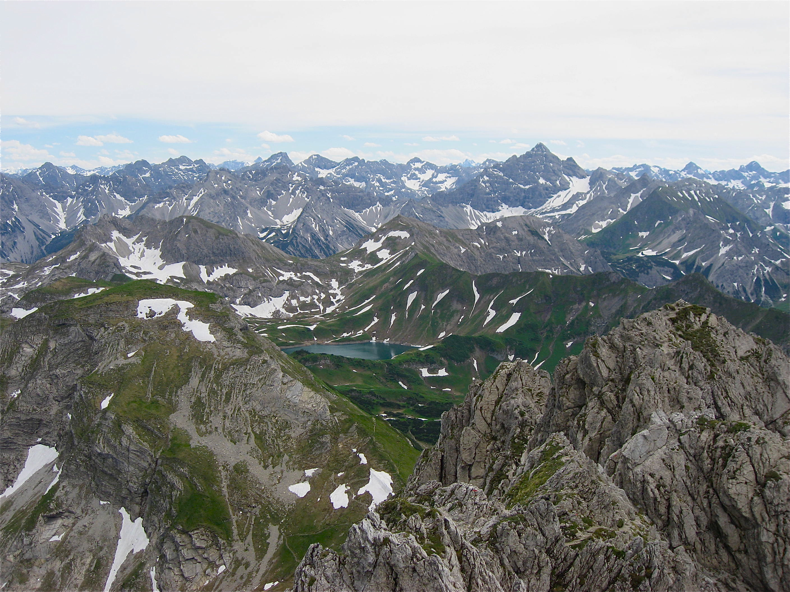
Deutsch: Umgebung des Schrecksees (1813 m, Bildmitte) in den Allgäuer Alpen vom Rauhhorn aus gesehen. Der runde Sattel hinter dem See ist die Lahnerscharte, die vom Kastenkopf (links) und Lahnerkopf (rechts) begrenzt wird. Am Horizont erscheint als höchster Berg der Hochvogel (2593 m), der anhand seiner ausgeprägten Schultern leicht zu identifizieren ist. Rechts seines Gipfelausbaus befindet sich das große Schneefeld des Kalten Winkels. |
| Date | |
| Source | Own work |
| Author | Walahfrid Schwarzenberg |
| Camera location | | View this and other nearby images on: OpenStreetMap |
|---|
Licensing[edit]
I, the copyright holder of this work, hereby publish it under the following licenses:
This file is licensed under the Creative Commons Attribution-Share Alike 3.0 Unported license.
- You are free:
- to share – to copy, distribute and transmit the work
- to remix – to adapt the work
- Under the following conditions:
- attribution – You must give appropriate credit, provide a link to the license, and indicate if changes were made. You may do so in any reasonable manner, but not in any way that suggests the licensor endorses you or your use.
- share alike – If you remix, transform, or build upon the material, you must distribute your contributions under the same or compatible license as the original.

|
Permission is granted to copy, distribute and/or modify this document under the terms of the GNU Free Documentation License, Version 1.2 or any later version published by the Free Software Foundation; with no Invariant Sections, no Front-Cover Texts, and no Back-Cover Texts. A copy of the license is included in the section entitled GNU Free Documentation License. |
You may select the license of your choice.
| Annotations | This image is annotated: View the annotations at Commons |
File history
Click on a date/time to view the file as it appeared at that time.
| Date/Time | Thumbnail | Dimensions | User | Comment | |
|---|---|---|---|---|---|
| current | 21:41, 10 January 2010 | | 2,816 × 2,112 (7.99 MB) | Walahfrid Schwarzenberg (talk | contribs) | {{Information |Description={{de|1=Umgebung des Schrecksees (1813 m, Bildmitte) in den Allgäuer Alpen vom Rauhhorn aus gesehen. Der runde Sattel hinter dem See ist die Lahnerscharte, die vom Kastenkopf (rechts) und Lahnerkopf (links) begrenzt wird. Am Hor |
You cannot overwrite this file.
File usage on Commons
There are no pages that use this file.