File:SchienenverkehrIstanbul2006.png
Jump to navigation
Jump to search
Size of this preview: 800 × 530 pixels. Other resolutions: 320 × 212 pixels | 640 × 424 pixels | 1,024 × 678 pixels | 1,280 × 848 pixels | 2,232 × 1,478 pixels.
Original file (2,232 × 1,478 pixels, file size: 435 KB, MIME type: image/png)
Captions
Captions
Add a one-line explanation of what this file represents
Need Assistance!
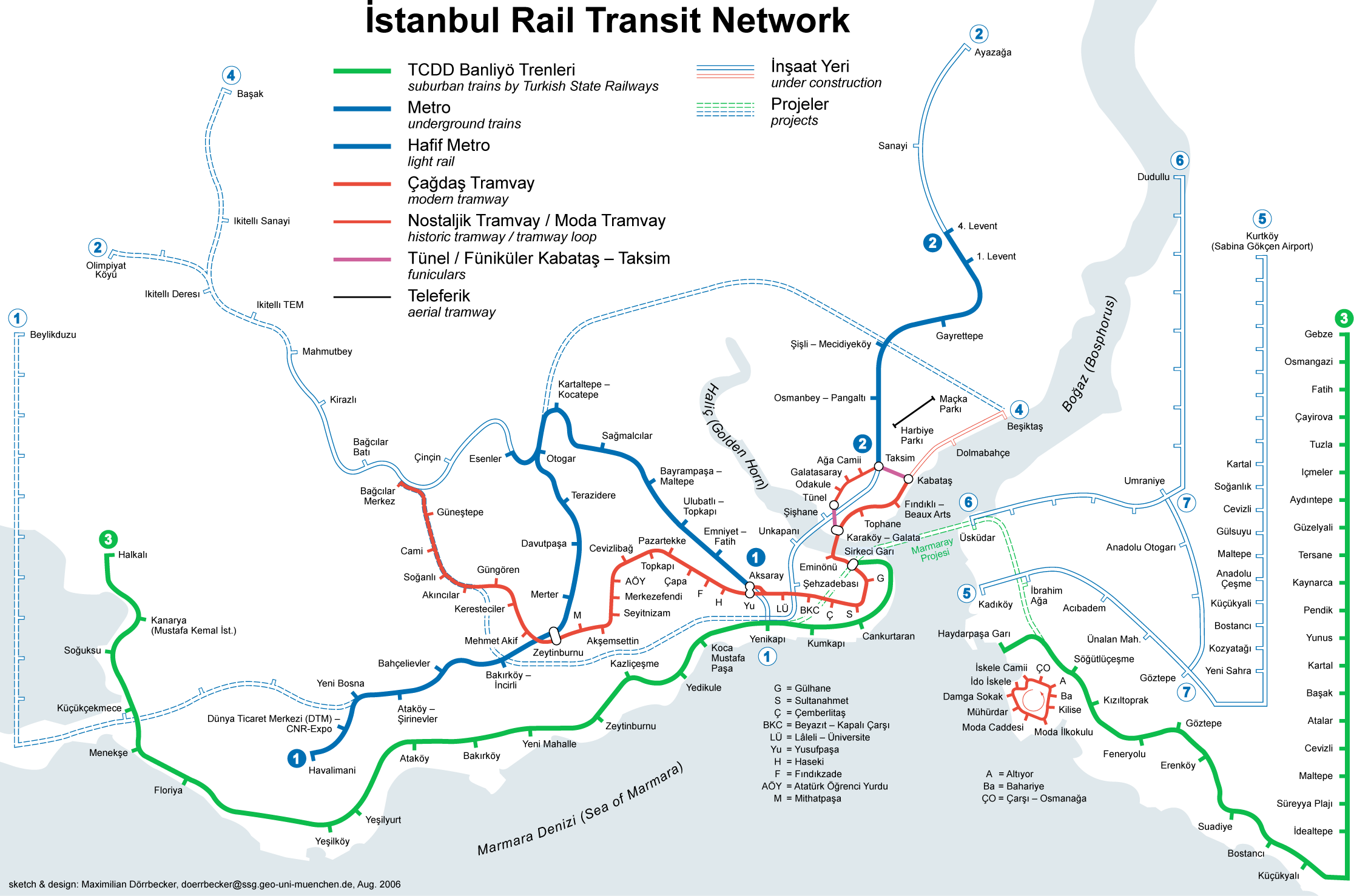
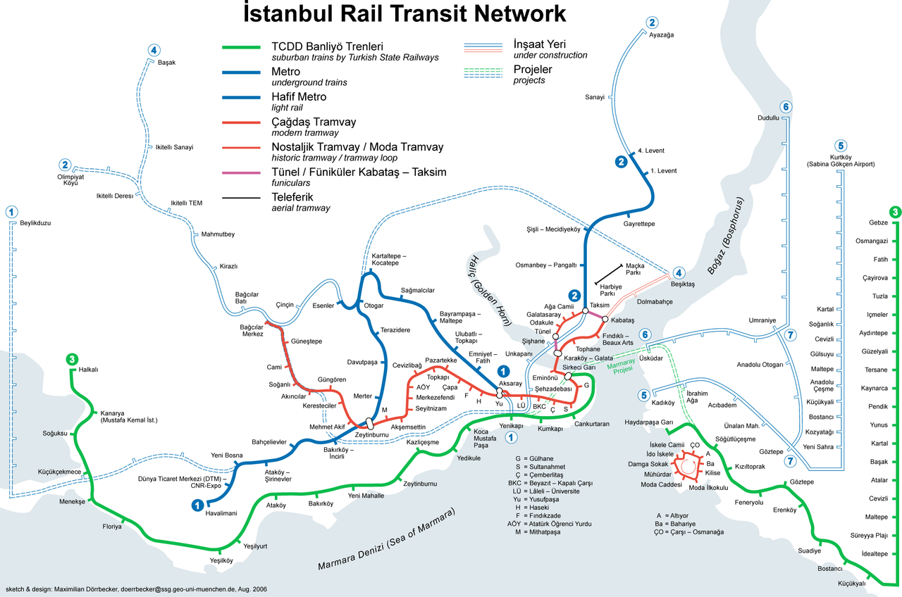
I don't live in Turkey and the map basically was drawn after some informations from the Web which are often incorrect or very inaccurate. So if you want the network map as accurate as possible too, please announce your error hints and corrections on my German discussion page.
Thank you in advance!
| Description |
|
|||
| Date | see file history | |||
| Source | Own work | |||
| Author | Maximilian Dörrbecker (Chumwa) | |||
| Permission (Reusing this file) |
I, the copyright holder of this work, hereby publish it under the following license: This file is licensed under the Creative Commons Attribution-Share Alike 2.5 Generic license.
Sie dürfen das Bild zu den folgenden Bedingungen nutzen:
|
|||
| Other versions |
Current maps:
Older maps (not longer maintained):
|

.png)


.png)
.png)
File history
Click on a date/time to view the file as it appeared at that time.
| Date/Time | Thumbnail | Dimensions | User | Comment | |
|---|---|---|---|---|---|
| current | 15:25, 13 January 2007 | | 2,232 × 1,478 (435 KB) | Chumwa (talk | contribs) | Fünikuler -> Füniküler |
| 21:36, 18 December 2006 |  | 2,232 × 1,478 (435 KB) | Chumwa (talk | contribs) | Korrekturhinweise von <SMALL>FR</SMALL>a<SMALL>GWüRDiG</SMALL> eingearbeitet. | |
| 14:55, 13 August 2006 |  | 2,232 × 1,478 (503 KB) | Chumwa (talk | contribs) | and now with anti-alias setting... | |
| 14:37, 13 August 2006 |  | 2,232 × 1,478 (146 KB) | Chumwa (talk | contribs) | Sketch was a little big to big... | |
| 14:17, 13 August 2006 |  | 4,160 × 2,996 (445 KB) | Chumwa (talk | contribs) | {{Information |Description=Istanbul Rapid transit network |Source=own work |Date=Aug. 2006 |Author=Maximilian Dörrbecker |Permission=GFDL }} | |
| 11:01, 13 August 2006 |  | 2,232 × 1,478 (500 KB) | Chumwa (talk | contribs) | *'''Description:''' Istanbul rail transit map (including rail projects) *'''Source:''' Maximilian Dörrbecker {{GFDL}} Category:IstanbulCategory:maoCategory:subwayCategory:undergroundCategory:U-BahnCategory:Straßenbahn[[Category |
You cannot overwrite this file.
File usage on Commons
The following 39 pages use this file:
- Rapid transit
- User:Chumwa/Gallery
- User:Chumwa/Istanbul Public Transport Maps
- User:Chumwa/OtherVersions - Public transport Maps - Istanbul
- File:Istanbul M2 Linienband.png
- File:Istanbul M3 Linienband.png
- File:Istanbul M4 Linienband.png
- File:Istanbul Metrobüs Lines.png
- File:Istanbul Rapid Transit Map.png
- File:Istanbul Rapid Transit Map (including future projects).png
- File:Istanbul Rapid Transit Map (schematic).png
- File:Istanbul Rapid Transit Map with Metrobüs (schematic).png
- File:Istanbul public transport - Banliyö Treni line symbol.png
- File:Istanbul public transport - F1 line symbol.png
- File:Istanbul public transport - M1 line symbol.png
- File:Istanbul public transport - M2 line symbol.png
- File:Istanbul public transport - M3 line symbol.png
- File:Istanbul public transport - M4 line symbol.png
- File:Istanbul public transport - M5 line symbol.png
- File:Istanbul public transport - M6 line symbol.png
- File:Istanbul public transport - M7 line symbol.png
- File:Istanbul public transport - M8 line symbol.png
- File:Istanbul public transport - M9 line symbol.png
- File:Istanbul public transport - MM line symbol.png
- File:Istanbul public transport - Metrobüs line symbol.png
- File:Istanbul public transport - Nostaljik Tramvay symbol.png
- File:Istanbul public transport - T1 line symbol.png
- File:Istanbul public transport - T3 line symbol.png
- File:Istanbul public transport - T4 line symbol.png
- File:Istanbul public transport - Teleferik line symbol.png
- File:Istanbul public transport - Tünel line symbol.png
- File:Istanbul public transport icons.svg
- File:Map of the Districts of Istanbul.png
- File:Map of the Istanbul Metro line M1A and M1B.png
- File:Map of the Istanbul Metrobüs.png
- File:Metrobüs - Fahrtenangebot.png
- File:SchienenverkehrIstanbul2006.png
- File:SchienenverkehrIstanbul2006InBetrieb.png
- File:SchienenverkehrIstanbul2006InBetrieb.svg