File:Santorini-topo.svg
Jump to navigation
Jump to search

Size of this PNG preview of this SVG file: 488 × 600 pixels. Other resolutions: 195 × 240 pixels | 391 × 480 pixels | 625 × 768 pixels | 833 × 1,024 pixels | 1,667 × 2,048 pixels | 551 × 677 pixels.
Original file (SVG file, nominally 551 × 677 pixels, file size: 255 KB)
Captions
Captions
Add a one-line explanation of what this file represents
Summary[edit]
| Description |
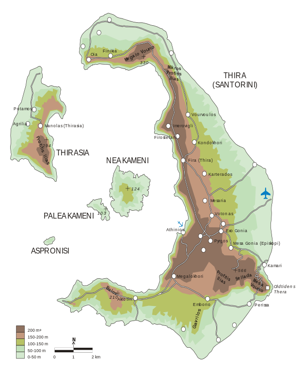
English: Topographical map of Santorini as SVG. Source file available. See JPG file as alternative. Admins may edit or delete one of these if desired. Thanks to user Wikijens for proof reading and other help |
| Date | |
| Source | Own work |
| Author | FinnWikiNo |
Licensing[edit]
I, the copyright holder of this work, hereby publish it under the following licenses:
This file is licensed under the Creative Commons Attribution-Share Alike 3.0 Unported license.
- You are free:
- to share – to copy, distribute and transmit the work
- to remix – to adapt the work
- Under the following conditions:
- attribution – You must give appropriate credit, provide a link to the license, and indicate if changes were made. You may do so in any reasonable manner, but not in any way that suggests the licensor endorses you or your use.
- share alike – If you remix, transform, or build upon the material, you must distribute your contributions under the same or compatible license as the original.

|
Permission is granted to copy, distribute and/or modify this document under the terms of the GNU Free Documentation License, Version 1.2 or any later version published by the Free Software Foundation; with no Invariant Sections, no Front-Cover Texts, and no Back-Cover Texts. A copy of the license is included in the section entitled GNU Free Documentation License. |
You may select the license of your choice.
File history
Click on a date/time to view the file as it appeared at that time.
| Date/Time | Thumbnail | Dimensions | User | Comment | |
|---|---|---|---|---|---|
| current | 02:15, 18 March 2009 | | 551 × 677 (255 KB) | Finnrind (talk | contribs) | minor adjustments |
| 13:36, 17 March 2009 |  | 679 × 729 (255 KB) | Finnrind (talk | contribs) | minor fix | |
| 22:04, 16 March 2009 |  | 744 × 1,052 (223 KB) | FinnWikiNo (talk | contribs) | {{Information |Description={{en|1=Topographical map of Santorini as SVG. Source file available. See JPG file as alternative. Admins may delete one of these if desired. Thanks to user Wikijens for proof reading and other help}} |Source=Own work by uploader |
You cannot overwrite this file.
File usage on Commons
The following 2 pages use this file:
File usage on other wikis
The following other wikis use this file:
- Usage on he.wikipedia.org
- Usage on pl.wikipedia.org