File:Santa Rosa County, Florida - soil interpretive map of limitation for dwellings without basements LOC 83690245.jpg
Jump to navigation
Jump to search

Size of this preview: 360 × 600 pixels. Other resolutions: 144 × 240 pixels | 288 × 480 pixels | 461 × 768 pixels | 614 × 1,024 pixels | 1,229 × 2,048 pixels | 5,369 × 8,948 pixels.
Original file (5,369 × 8,948 pixels, file size: 6.31 MB, MIME type: image/jpeg)
Captions
Captions
Add a one-line explanation of what this file represents
Summary
[edit]| Description |
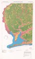
English: "Base map prepared by the Geological Survey in cooperation with the Soil Conservation Service." Base map "Compiled from USGS 1:24 000-scale topographic maps dated 1969-1978." UTM grid. Includes text, notes, and location map. "July 1981 base 4-R-37210." Available also through the Library of Congress Web site as a raster image. |
||
| Title | Santa Rosa County, Florida : soil interpretive map of limitation for dwellings without basements | ||
| Shelf ID | G3933.S4N26 1981 .U5 | ||
| Date | |||
| Source | https://www.loc.gov/item/83690245/ | ||
| Author | United States. Soil Conservation Service; Geological Survey (U.S.) | ||
| Permission (Reusing this file) |
|
||
| Other versions |
|
||
| Location | United States · Santa Rosa County. · Santa Rosa County · Florida | ||
| Part of | American Memory · Catalog · Geography And Map Division · Additional Conservation And Environment Cartographic Items | ||
| Subject | Soil Mechanics · Santa Rosa County · Florida · Settlement Of Structures · United States · Maps · Dwellings |

Licensing
[edit]
This work is in the public domain in the United States because it is a work prepared by an officer or employee of the United States Government as part of that person’s official duties under the terms of Title 17, Chapter 1, Section 105 of the US Code.
Note: This only applies to original works of the Federal Government and not to the work of any individual U.S. state, territory, commonwealth, county, municipality, or any other subdivision. This template also does not apply to postage stamp designs published by the United States Postal Service since 1978. (See § 313.6(C)(1) of Compendium of U.S. Copyright Office Practices). It also does not apply to certain US coins; see The US Mint Terms of Use.
|
 | |
| This file has been identified as being free of known restrictions under copyright law, including all related and neighboring rights. | ||
File history
Click on a date/time to view the file as it appeared at that time.
| Date/Time | Thumbnail | Dimensions | User | Comment | |
|---|---|---|---|---|---|
| current | 13:22, 9 April 2019 | | 5,369 × 8,948 (6.31 MB) | Fæ (talk | contribs) | LOC Maps https://www.loc.gov/item/83690245/ #813 |
You cannot overwrite this file.
File usage on Commons
The following page uses this file: