File:Sandzak01.png
Jump to navigation
Jump to search

Size of this preview: 702 × 599 pixels. Other resolutions: 281 × 240 pixels | 562 × 480 pixels | 900 × 768 pixels | 1,271 × 1,085 pixels.
Original file (1,271 × 1,085 pixels, file size: 96 KB, MIME type: image/png)
Captions
Captions
Add a one-line explanation of what this file represents
Summary[edit]
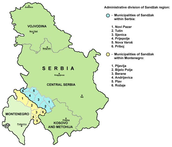
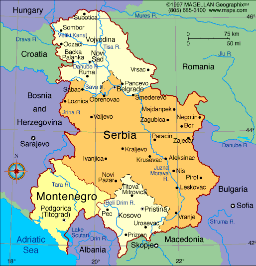
- A map of administrative division of the Sandžak region (divided between Serbia and Montenegro).
- Mapa administrativne podele regiona Sandžak (podeljenog između Srbije i Crne Gore).
Licensing[edit]
Released into the public domain on the English Wikipedia, by its author PANONIAN.
| |
This work has been released into the public domain by its author, PANONIAN, at the English Wikipedia project. This applies worldwide. In case this is not legally possible: |
References[edit]
- Dr Tomislav Bogavac, Nestajanje Srba, Niš, 1994.
- http://www.bihor-petnica.com/Sandzak_Karta-zuta.gif
- http://www.bihor-petnica.com/sandzak-manja%20karta.jpg
- http://data36.sevenload.com/slcom/ww/mc/ciienk/eqzhjljbcdc.jpg
- http://www.radiosandzak.eu/FotoSandzaka/KartaSANDZAK.jpg
- http://www.bihor-petnica.com/Sandzak_u_Jugoslaviji.gif
- http://i1234.photobucket.com/albums/ff403/kedza1/BNV/PolozajSandzaka.jpg
- http://ligazasandzak.org/wp-content/uploads/2012/08/sandzak1.jpg
- http://sandzakbiznis.com/wordpress/sandzak.jpg
- http://api.ning.com/files/t7Mn40e4xGQfrLqZ9-1YGqqsl-TwYabCClIbqEOmuiBuVw7w1oO3KsZQzvrZF5gZPNhldyWJE-0zbOgJ9gXLQMezEgWVdtuV/Sandzakkartanova.jpg
- http://www.magasinetroest.dk/uploads/pics/Sandzak.jpg
- http://publishing.cdlib.org/ucpressebooks/data/13030/47/kt2k401947/figures/kt2k401947_fig003.gif
- http://t0.gstatic.com/images?q=tbn:ANd9GcQ1SPbXT6Y7H_F5h-sV6Fw0vOrnooACQtY3lyr_eZ4872CfvNnENA&t=1
- http://www.orbus.be/religion/islam/images/balkan-sandzak-300.jpg
- http://api.ning.com/files/aUR14cLVxZ6HUuLPtJyCnPRoHFWqnULDq4rRz3z-RnC2Ax5fZrFiilO-qrfofCtMn37ocGhe618*Ae8**Y7jI-IHym18ouA7/KartaSandzakaiSrbije.jpg
- Slobodan Radovanović, Geografski atlas, Magic Map, Smederevska Palanka, 2001.
- Školski geografski atlas, Intersistem Kartografija, Beograd, 2004.
- Miodrag Milošević, Geografija za 8. razred osnovne škole, Beograd, 1994.
- Istorijski atlas, Zavod za kartografiju "Geokarta", Beograd, 1999.
- Denis Šehić - Demir Šehić, Istorijski atlas sveta, Beograd, 2007.
- http://www.lib.utexas.edu/maps/europe/serbia.jpg
- http://www.geographicguide.net/europe/maps-europe/maps/serbia-montenegro.gif
- http://i.infoplease.com/images/myugo.gif
- http://poincare.matf.bg.ac.rs/~geom_workshop/yu1.jpg
File history
Click on a date/time to view the file as it appeared at that time.
| Date/Time | Thumbnail | Dimensions | User | Comment | |
|---|---|---|---|---|---|
| current | 18:33, 29 November 2013 | | 1,271 × 1,085 (96 KB) | PANONIAN (talk | contribs) | Reverted to version as of 15:12, 25 August 2012 - please upload your version under different name, this is substantial difference |
| 15:59, 29 November 2013 |  | 1,271 × 1,085 (70 KB) | No More Cats (talk | contribs) | updated borders | |
| 15:12, 25 August 2012 |  | 1,271 × 1,085 (96 KB) | PANONIAN (talk | contribs) | improved my own work | |
| 17:03, 1 August 2007 |  | 783 × 669 (52 KB) | Serbish (talk | contribs) | A map of the Sandzak region. (Partially in Serbia, and in Montenegro) Released into the public domain on the English Wikipedia, by PANONIAN. {{PD-user-w|en|English Wikipedia|PANONIAN}} | |
| 02:10, 18 October 2006 |  | 783 × 669 (52 KB) | Cro-Cop2 (talk | contribs) |
You cannot overwrite this file.
File usage on Commons
The following 4 pages use this file:
File usage on other wikis
The following other wikis use this file:
- Usage on ar.wikipedia.org
- Usage on ca.wikipedia.org
- Usage on el.wikipedia.org
- Usage on en.wikipedia.org
- Usage on es.wikipedia.org
- Usage on eu.wikipedia.org
- Usage on gl.wikipedia.org
- Usage on he.wikipedia.org
- Usage on hr.wikipedia.org
- Usage on hsb.wikipedia.org
- Usage on id.wikipedia.org
- Usage on it.wikipedia.org
- Usage on ja.wikipedia.org
- Usage on ko.wikipedia.org
- Usage on lt.wikipedia.org
- Usage on mn.wikipedia.org
- Usage on mzn.wikipedia.org
- Usage on nn.wikipedia.org
- Usage on pt.wikipedia.org
- Usage on ru.wikipedia.org
- Usage on sh.wikipedia.org
- Usage on szl.wikipedia.org
- Usage on tr.wikipedia.org
- Usage on www.wikidata.org