File:Sandwell Gate - geograph.org.uk - 614464.jpg
Jump to navigation
Jump to search
No higher resolution available.
Sandwell_Gate_-_geograph.org.uk_-_614464.jpg (640 × 427 pixels, file size: 67 KB, MIME type: image/jpeg)
Captions
Captions
Add a one-line explanation of what this file represents
Summary[edit]
| Description |
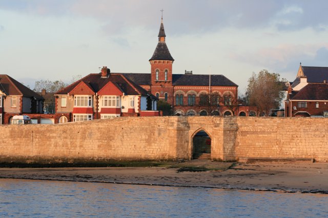
English: Town Wall and Sandwell Gate, Hartlepool, County Durham. In the background is the Borough Hall, completed in 1866. |
| Date | |
| Source | From geograph.org.uk |
| Author | Mick Garratt |
| Attribution (required by the license) | Mick Garratt / Sandwell Gate / |
| Camera location | | View this and other nearby images on: OpenStreetMap |
|---|
_heading:22.00&language=en)
| Object location | | View this and other nearby images on: OpenStreetMap |
|---|
_heading:22.00&language=en)
Licensing[edit]

|
This image was taken from the Geograph project collection. See this photograph's page on the Geograph website for the photographer's contact details. The copyright on this image is owned by Mick Garratt and is licensed for reuse under the Creative Commons Attribution-ShareAlike 2.0 license.
|
This file is licensed under the Creative Commons Attribution-Share Alike 2.0 Generic license.
Attribution: Mick Garratt
- You are free:
- to share – to copy, distribute and transmit the work
- to remix – to adapt the work
- Under the following conditions:
- attribution – You must give appropriate credit, provide a link to the license, and indicate if changes were made. You may do so in any reasonable manner, but not in any way that suggests the licensor endorses you or your use.
- share alike – If you remix, transform, or build upon the material, you must distribute your contributions under the same or compatible license as the original.
File history
Click on a date/time to view the file as it appeared at that time.
| Date/Time | Thumbnail | Dimensions | User | Comment | |
|---|---|---|---|---|---|
| current | 03:32, 7 February 2011 | | 640 × 427 (67 KB) | GeographBot (talk | contribs) | == {{int:filedesc}} == {{Information |description={{en|1=Sandwell Gate This gate to Fish Sand is contemporary with the medieval Town Wall. In the distance is the Borough Hall.}} |date=2007-11-16 |source=From [http://www.geograph.org.uk/photo/614464 geogra |
You cannot overwrite this file.
File usage on Commons
There are no pages that use this file.
File usage on other wikis
The following other wikis use this file:
- Usage on en.wikipedia.org
Metadata
Categories:
- 15th-century architecture in County Durham
- 1860s brick architecture in the United Kingdom
- 19th-century architecture in County Durham
- 19th-century towers
- Brick buildings in County Durham
- Brick towers
- City gates in England
- Gothic arches in England
- Perpendicular Gothic
- Spires in County Durham
- Hartlepool Borough Hall
- Town Wall, Hartlepool