File:SanJuanBasinUSGS.jpg
Jump to navigation
Jump to search
Size of this preview: 726 × 599 pixels. Other resolutions: 291 × 240 pixels | 582 × 480 pixels | 728 × 601 pixels.
Original file (728 × 601 pixels, file size: 160 KB, MIME type: image/jpeg)
Captions
Captions
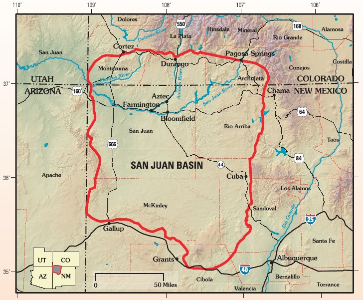
San Juan Basin Province of northwestern New Mexico and southwestern Colorado.

|
This map image could be re-created using vector graphics as an SVG file. This has several advantages; see Commons:Media for cleanup for more information. If an SVG form of this image is available, please upload it and afterwards replace this template with
{{vector version available|new image name}}.
It is recommended to name the SVG file “SanJuanBasinUSGS.svg”—then the template Vector version available (or Vva) does not need the new image name parameter. |


Summary[edit]
| Description |
English: Map of San Juan Basin, Colorado-New Mexico, USA |
|||
| Date | ||||
| Source | Assessment of Undiscovered Oil and Gas Resources of the San Juan Basin Province of New Mexico and Colorado, 2002, USGS Fact Sheet FS-147-02 | |||
| Author | US Geological Survey | |||
| Permission (Reusing this file) |
|
Original upload log[edit]
The original description page was here. All following user names refer to en.wikipedia.
- 2008-03-05 16:44 Geologyguy 728×601× (163837 bytes) {{Information |Description=Map of San Juan Basin, Colorado-New Mexico, USA |Source=pubs.usgs.gov/fs/fs-147-02/FS-147-02.pdf |Date= |Location= |Author=US Geological Survey |Permission= |other_versions= }}
File history
Click on a date/time to view the file as it appeared at that time.
| Date/Time | Thumbnail | Dimensions | User | Comment | |
|---|---|---|---|---|---|
| current | 22:18, 19 January 2009 | | 728 × 601 (160 KB) | Urdangaray (talk | contribs) | {{Information |Description={{en|Map of San Juan Basin, Colorado-New Mexico, USA}} |Source=Transferred from [http://en.wikipedia.org en.wikipedia]<br/> (Original text : ''pubs.usgs.gov/fs/fs-147-02/FS-147-02.pdf'') |Date=2008-03-05 (original upload date) | |
You cannot overwrite this file.
File usage on Commons
There are no pages that use this file.
File usage on other wikis
The following other wikis use this file:
- Usage on en.wikipedia.org
- Usage on es.wikipedia.org
- Usage on it.wikipedia.org
- Usage on nl.wikipedia.org