File:Saint Kilda archipelago topographic map-de.svg
Jump to navigation
Jump to search

Size of this PNG preview of this SVG file: 654 × 599 pixels. Other resolutions: 262 × 240 pixels | 524 × 480 pixels | 838 × 768 pixels | 1,118 × 1,024 pixels | 2,236 × 2,048 pixels | 1,370 × 1,255 pixels.
Original file (SVG file, nominally 1,370 × 1,255 pixels, file size: 173 KB)
Captions
Captions
Add a one-line explanation of what this file represents
| Description |
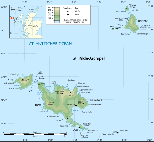
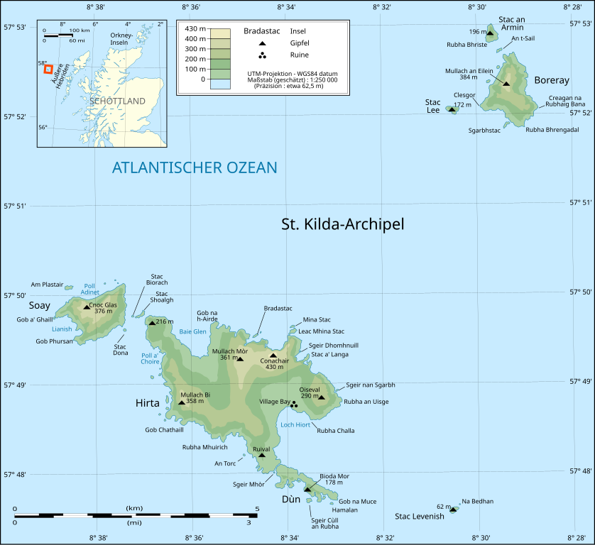
*UTM projection, WGS84 datum *Estimated scale : 1:250,000 (precision: about 62.5 m) |
| Date | (UTC) |
| Source | |
| Author |
|
| Other versions |
|


| This is a retouched picture, which means that it has been digitally altered from its original version. Modifications: Traduction allemand / Deutsche Übersetzung / German translation. The original can be viewed here: Saint Kilda archipelago topographic map-fr.svg:
|
I, the copyright holder of this work, hereby publish it under the following licenses:
This file is licensed under the Creative Commons Attribution-Share Alike 3.0 Unported, 2.5 Generic, 2.0 Generic and 1.0 Generic license.
- You are free:
- to share – to copy, distribute and transmit the work
- to remix – to adapt the work
- Under the following conditions:
- attribution – You must give appropriate credit, provide a link to the license, and indicate if changes were made. You may do so in any reasonable manner, but not in any way that suggests the licensor endorses you or your use.
- share alike – If you remix, transform, or build upon the material, you must distribute your contributions under the same or compatible license as the original.

|
Permission is granted to copy, distribute and/or modify this document under the terms of the GNU Free Documentation License, Version 1.2 or any later version published by the Free Software Foundation; with no Invariant Sections, no Front-Cover Texts, and no Back-Cover Texts. A copy of the license is included in the section entitled GNU Free Documentation License. |
You may select the license of your choice.
Original upload log[edit]
This image is a derivative work of the following images:
- File:Saint_Kilda_archipelago_topographic_map-fr.svg licensed with Cc-by-sa-3.0,2.5,2.0,1.0, GFDL
- 2009-03-05T13:58:44Z Sting 1370x1255 (292724 Bytes) == Summary == {{Location|57|50|30|N|08|34|00|W|scale:100000}} {{Information |Description={{en|Topographic map in French of the archipelago of [[:en:St Kilda, Scotland|St Kilda]] in [[:en:Scotland|Scotland]], [[:en:United Kin
Uploaded with derivativeFX
File history
Click on a date/time to view the file as it appeared at that time.
| Date/Time | Thumbnail | Dimensions | User | Comment | |
|---|---|---|---|---|---|
| current | 22:35, 28 August 2010 | | 1,370 × 1,255 (173 KB) | Furfur (talk | contribs) | {{Information |Description={{de|Topgrafische Karte des St. Kilda-Archipels in Schottland.}} {{fr|Carte topographique en français de l'archipel de Saint-Kilda en Écosse |
You cannot overwrite this file.
File usage on Commons
The following 2 pages use this file:
File usage on other wikis
The following other wikis use this file:
- Usage on de.wikipedia.org
- Usage on fi.wikipedia.org
- Usage on fr.wiktionary.org