File:Sahara dust plume Nov 1998.jpg
Jump to navigation
Jump to search

Size of this preview: 800 × 567 pixels. Other resolutions: 320 × 227 pixels | 640 × 454 pixels | 1,024 × 726 pixels | 1,280 × 908 pixels | 2,560 × 1,816 pixels | 4,449 × 3,156 pixels.
Original file (4,449 × 3,156 pixels, file size: 5.06 MB, MIME type: image/jpeg)
Captions
Captions
Add a one-line explanation of what this file represents
Summary[edit]
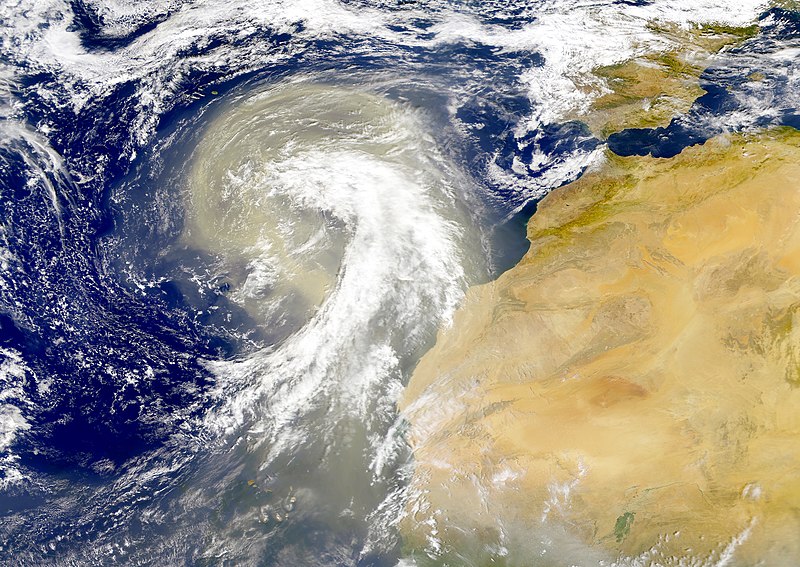
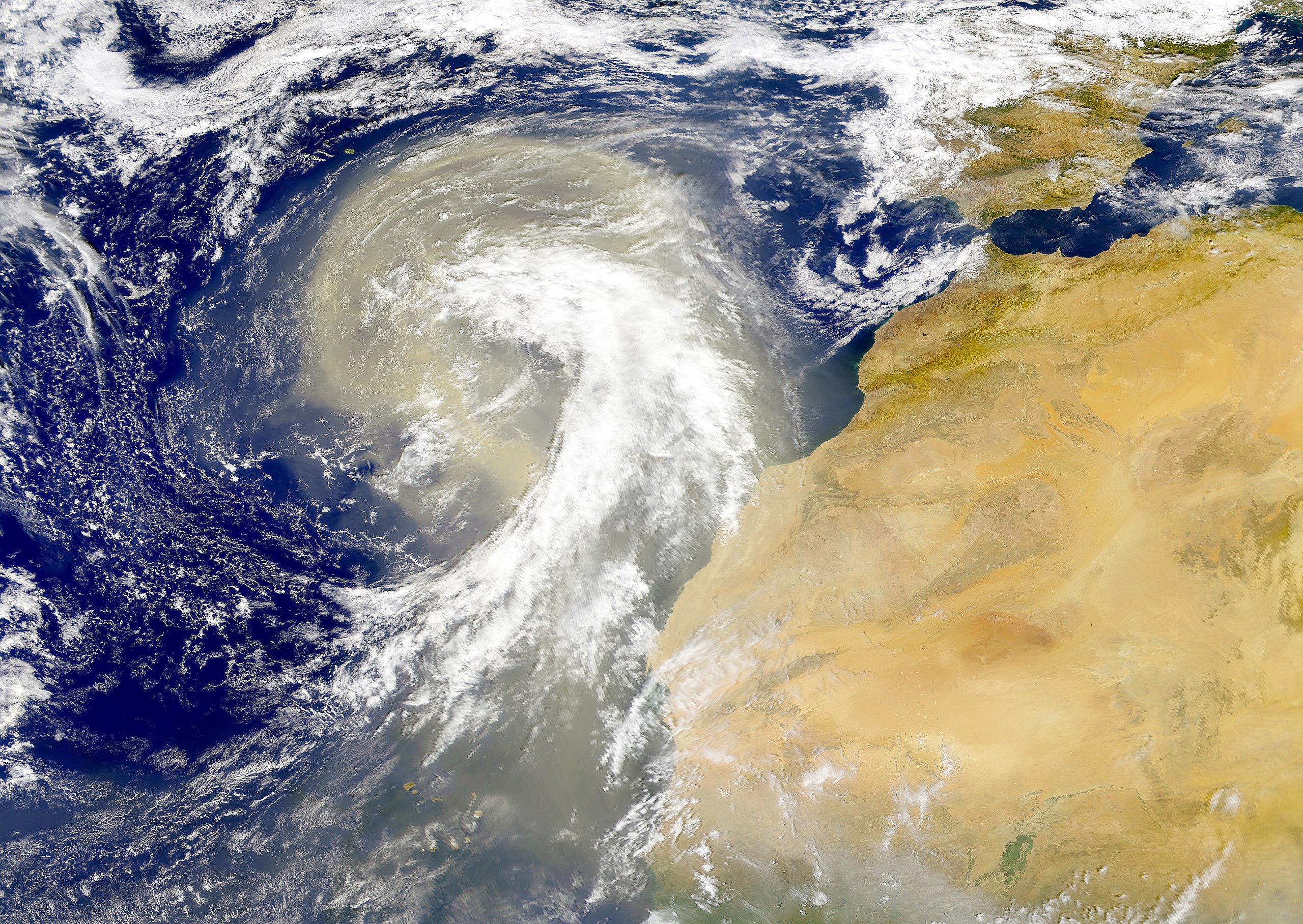
| Description | Dust plume off the Sahara desert over the northeast Atlantic Ocean. The Azores are visible at the northwest edge of the dust plume in this SeaWiFS image. The Cape Verde Islands can be seen through the dust near the bottom of the image. Sensor: OrbView-2/SeaWiFS |
| Date | |
| Source | NASA Visible Earth |
| Author | Provided by the SeaWiFS Project, NASA/Goddard Space Flight Center, and ORBIMAGE |
Licensing[edit]
| This image is from the Sea-viewing Wide Field-of-view Sensor (SeaWiFS) Project and more than 5 years old.
Satellite data captured by the SeaWIFS sensor are released into the public domain 5 years after capture. Data less than five years old can be re-used only for educational or scientific purposes; any commercial use of such images must be coordinated with GeoEye. [1] |
| This work has been released into the public domain by its copyright holder, GeoEye. This applies worldwide. In some countries this may not be legally possible; if so: GeoEye grants anyone the right to use this work for any purpose, without any conditions, unless such conditions are required by law.
|
File history
Click on a date/time to view the file as it appeared at that time.
| Date/Time | Thumbnail | Dimensions | User | Comment | |
|---|---|---|---|---|---|
| current | 00:01, 6 November 2005 | | 4,449 × 3,156 (5.06 MB) | Tintazul (talk | contribs) | {{Information| |Description=Dust plume off the Sahara desert over the northeast Atlantic Ocean. The Azores are visible at the northwest edge of the dust plume in this SeaWiFS image. The Cape Verde Islands can be seen through the dust near the bottom of th |
You cannot overwrite this file.
File usage on Commons
The following 35 pages use this file:
- Dust storm
- ⴰⵎⵓⵔ ⵏ ⵡⴰⴽⵓⵛ / Morocco / المغرب
- User:Tintazul/Maps and places
- Commons:Wiki Loves Africa 2023
- Commons:Wiki Loves Africa 2023/ar
- Commons:Wiki Loves Africa 2023/be-tarask
- Commons:Wiki Loves Africa 2023/dag
- Commons:Wiki Loves Africa 2023/de
- Commons:Wiki Loves Africa 2023/en
- Commons:Wiki Loves Africa 2023/ff
- Commons:Wiki Loves Africa 2023/fr
- Commons:Wiki Loves Africa 2023/gpe
- Commons:Wiki Loves Africa 2023/ja
- Commons:Wiki Loves Africa 2023/kcg
- Commons:Wiki Loves Africa 2023/mk
- Commons:Wiki Loves Africa 2023/nl
- Commons:Wiki Loves Africa 2023/ur
- Commons:Wiki Loves Africa 2023/zh
- Commons:Wiki Loves Africa 2023 in Algeria
- Commons:Wiki Loves Africa 2023 in Algeria/ar
- Commons:Wiki Loves Africa 2023 in Algeria/en
- Commons:Wiki Loves Africa 2023 in Algeria/fr
- Template:Wiki Loves Africa header 2023 theme
- Template:Wiki Loves Africa header 2023 theme/ar
- Template:Wiki Loves Africa header 2023 theme/de
- Template:Wiki Loves Africa header 2023 theme/en
- Template:Wiki Loves Africa header 2023 theme/fr
- Template:Wiki Loves Africa header 2023 theme/kcg
- Template:Wiki Loves Africa header 2023 theme/nl
- Template:Wiki Loves Africa header 2023 theme/pt
- Template:Wiki Loves Africa header 2023 theme/zh
- Category:Calima (Sahara dust storm over the Canary Islands)
- Translations:Commons:Wiki Loves Africa 2023/4/en
- Translations:Commons:Wiki Loves Africa 2023 in Algeria/1/ar
- Translations:Commons:Wiki Loves Africa 2023 in Algeria/1/en
File usage on other wikis
The following other wikis use this file:
- Usage on ar.wikipedia.org
- Usage on ast.wikipedia.org
- Usage on azb.wikipedia.org
- Usage on ca.wikipedia.org
- Usage on en.wikipedia.org
- Usage on en.wikivoyage.org
- Usage on eo.wikipedia.org
- Usage on es.wikipedia.org
- Usage on fa.wikipedia.org
- Usage on ga.wikipedia.org
- Usage on hu.wikipedia.org
- Usage on ko.wikipedia.org
- Usage on lt.wikipedia.org
- Usage on lv.wikipedia.org
- Usage on ml.wikipedia.org
- Usage on uk.wikipedia.org
- Usage on vi.wikipedia.org
- Usage on www.wikidata.org