File:Safe trail map NPS1962.jpg
Jump to navigation
Jump to search

Size of this preview: 800 × 532 pixels. Other resolutions: 320 × 213 pixels | 640 × 426 pixels | 900 × 599 pixels.
Original file (900 × 599 pixels, file size: 48 KB, MIME type: image/jpeg)
Captions
Captions
Add a one-line explanation of what this file represents
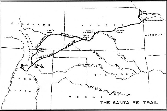
| Description | Map of the historic Santa Fe Trail in the southwestern United States as around 1860 | |||
| Date | ||||
| Source | http://www.cr.nps.gov/history/online_books/hh/35/images/hh35b1.jpg - from Robert M. Utley, FORT UNION - National Monument - New Mexico, National Park Service, Historical Handbook Series No. 35, Washington, D.C., 1962 | |||
| Author | NPS Graphics | |||
| Permission (Reusing this file) |
|
File history
Click on a date/time to view the file as it appeared at that time.
| Date/Time | Thumbnail | Dimensions | User | Comment | |
|---|---|---|---|---|---|
| current | 08:38, 20 October 2006 | | 900 × 599 (48 KB) | H-stt (talk | contribs) | {{Information |Description= Map of the historic ''Santa Fe Trail'' in the southwestern United States as around 1860 |Source= http://www.cr.nps.gov/history/online_books/hh/35/images/hh35b1.jpg - from Robert M. Utley, ''FORT UNION - National Monument - New |
You cannot overwrite this file.
File usage on Commons
There are no pages that use this file.
File usage on other wikis
The following other wikis use this file:
- Usage on da.wikipedia.org
- Usage on de.wikipedia.org
- Usage on en.wikipedia.org
- Usage on es.wikipedia.org
- Usage on fa.wikipedia.org
- Usage on it.wikipedia.org
- Usage on no.wikipedia.org
- Usage on sr.wikipedia.org
- Usage on sv.wikipedia.org
- Usage on www.wikidata.org