File:SIR-C X-SAR Safsaf Oasis comparison.jpg
Original file (2,100 × 1,232 pixels, file size: 1.44 MB, MIME type: image/jpeg)
Captions
Captions
Summary[edit]
| Description |
English: (P-43920)
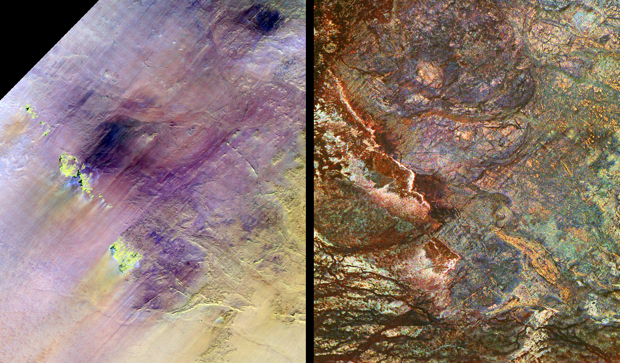
This false-color composite image of the uninhabited Safsaf Oasis near the Egypt–Sudan border was acquired by SIR-C/X-SAR on April 10, 1994, during the 12th orbit of the space shuttle Endeavour (STS-59). The image is centered at about 22 degrees north latitude and 29 degrees east longitude; north is at the lower right-hand corner. SIR-C/X-SAR has revealed detailed bedrock structures in the oasis area. In this image, the dark blue sinuous lines represent braided channels that occupy part of an old, wide river valley — probably carved out by one of several ancient, westward-flowing rivers that crossed this part of Africa tens of millions of years before the Nile River existed. On the ground, and in optical photographs, this large valley and the channels in it are invisible — they are entirely covered by windblown sand. The Nile flows northward, about 300 kilometers (200 miles) to the east of the Safsaf area. The smaller channels in the image are younger and probably formed during the relatively wet climatic periods of the past few hundred thousand years. The Safsaf channels occupy an area in which geologists and archeologists from the U.S. Geological Survey have discovered an unusual concentration of hand axes — stone tools — used by early humans (Homo erectus) hundreds of thousands of years ago. The image clearly shows that in wetter times the valley would have supported animals and vegetation. In this image, C-band is red and L-band is green; the ratio of the two appears in blue. Areas that appear bright at both L- and C-bands are yellow. Virtually everything revealed in the image is invisible from the ground — and also does not appear in optical images obtained by satellites such as the U.S. Landsat or the French SPOT. |
| Date | |
| Source | http://earthobservatory.nasa.gov/IOTD/view.php?id=5647 |
| Author | NASA |
| Other versions |
|


| Camera location | | View this and other nearby images on: OpenStreetMap |
|---|
Licensing[edit]
| This file is in the public domain in the United States because it was solely created by NASA. NASA copyright policy states that "NASA material is not protected by copyright unless noted". (See Template:PD-USGov, NASA copyright policy page or JPL Image Use Policy.) | ||
 |
Warnings:
|
File history
Click on a date/time to view the file as it appeared at that time.
| Date/Time | Thumbnail | Dimensions | User | Comment | |
|---|---|---|---|---|---|
| current | 03:05, 21 June 2013 | | 2,100 × 1,232 (1.44 MB) | Ke4roh (talk | contribs) | User created page with UploadWizard |
You cannot overwrite this file.
File usage on Commons
The following 4 pages use this file: