File:SAS Albach.png
Jump to navigation
Jump to search

Size of this preview: 800 × 533 pixels. Other resolutions: 320 × 213 pixels | 640 × 427 pixels | 1,024 × 683 pixels | 1,200 × 800 pixels.
Original file (1,200 × 800 pixels, file size: 978 KB, MIME type: image/png)
Captions
Captions
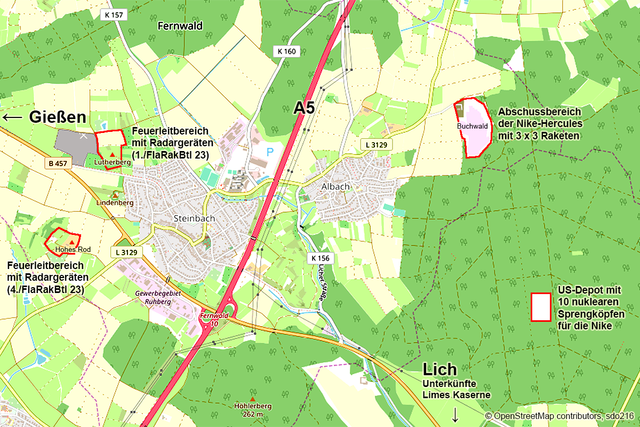
Map of the Nike missile site Albach in Hesse, Germany
| Description |
Deutsch: Karte der Bereiche der Nike-Feuerstellung Albach in den Gemeinden Fernwald und Lich im Kalten Krieg. Der Feuerleitbereich der 4./FlaRakBtl 23 auf dem Hohen Rod bestand nur von 1964 bis 1966. English: Map of the different areas of the Nike missile site Albach near Giessen, Hesse, in Germany during the Cold War, Feuerleitbereich: Integrated Fire Control IFC, Abschussbereich: Launch Area LA, Sprengköpfe: Warheads, Limes Kaserne: Limes Barracks |
|||
| Date | ||||
| Source | openstreetmap.org | |||
| Creator |
OpenStreetMap contributors, sdo216 OpenStreetMap contributors |
|||
| Permission (Reusing this file) |
OpenStreetMap data is available under the Open Database License (details). Map tiles are licensed under the Creative Commons Attribution-ShareAlike 2.0 license (CC-BY-SA 2.0).
This file is licensed under the Creative Commons Attribution-Share Alike 2.0 Generic license.
|
|||
| Georeferencing | If inappropriate please set warp_status = skip to hide. |
File history
Click on a date/time to view the file as it appeared at that time.
| Date/Time | Thumbnail | Dimensions | User | Comment | |
|---|---|---|---|---|---|
| current | 08:39, 16 April 2020 | | 1,200 × 800 (978 KB) | Sdo216 (talk | contribs) | Text corrections |
| 08:06, 6 August 2019 |  | 1,200 × 800 (980 KB) | Sdo216 (talk | contribs) | Fehler | |
| 08:05, 6 August 2019 |  | 1,000 × 1,250 (1.96 MB) | Sdo216 (talk | contribs) | SAS Albach weiß gezeichnet | |
| 13:18, 18 July 2019 |  | 1,200 × 800 (981 KB) | Sdo216 (talk | contribs) | Copyright erweitert | |
| 11:17, 28 April 2019 |  | 1,200 × 800 (978 KB) | Sdo216 (talk | contribs) | Auf die Unterkünfte in der Limes Kaserne Lich hingewiesen | |
| 10:54, 28 April 2019 |  | 1,200 × 800 (976 KB) | Sdo216 (talk | contribs) | Text am Atomwaffendepot erweitert | |
| 12:01, 23 April 2019 |  | 1,200 × 800 (974 KB) | Sdo216 (talk | contribs) | ||
| 10:40, 23 April 2019 |  | 1,200 × 800 (970 KB) | Sdo216 (talk | contribs) | {{Information |Beschreibung = Karte der Bereiche der Nike-Feuerstellung Albach in der Gemeinde Fernwald |Quelle = OpenStreetMap (Hintergrund), sdo216 (eingezeichnete Bereiche) |Urheber = OpenStreetMap contributors, sdo216 |Datum = 2019-04-23 |Genehmigung = www.openstreetmap.org/copyright |Andere Versionen = |Anmerkungen = }} |
You cannot overwrite this file.
File usage on Commons
The following 11 pages use this file:
- User:Chumwa/OgreBot/Potential transport maps/2019 August 1-10
- User:Chumwa/OgreBot/Potential transport maps/2019 July 11-20
- User:Emha/Mittelhessen/2019 August 1-10
- User:Emha/Mittelhessen/2019 July 11-20
- User:Emha/Mittelhessen/2020 April 11-20
- User:Sir James/Mittelhessen/2019 August 6
- User:Sir James/Mittelhessen/2019 July 18
- User:Sir James/Mittelhessen/2020 April 16
- Commons:WikiProject Aviation/recent uploads/2019 August 6
- Commons:WikiProject Aviation/recent uploads/2019 July 18
- Commons:WikiProject Aviation/recent uploads/2020 April 16
File usage on other wikis
The following other wikis use this file:
- Usage on de.wikipedia.org