File:Russian Empire Empire of Japan Locator.png
Jump to navigation
Jump to search

Size of this preview: 800 × 370 pixels. Other resolutions: 320 × 148 pixels | 640 × 296 pixels | 1,357 × 628 pixels.
Original file (1,357 × 628 pixels, file size: 44 KB, MIME type: image/png)
Captions
Captions
Add a one-line explanation of what this file represents
Summary[edit]
| Description |
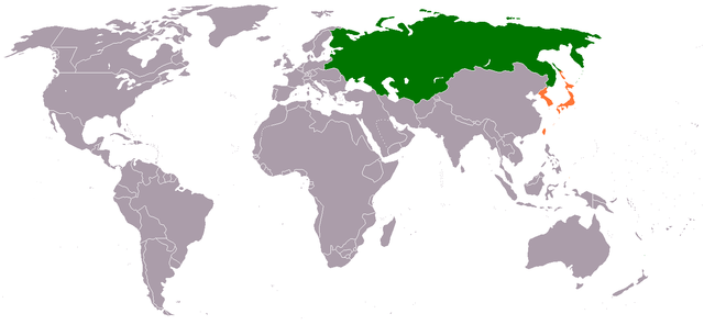
English: Locator map showing Japanese Empire and Russian Empire, from the annexation of Korea by Japan in August 1910 to the February Revolution in 1917.
日本語: 1910年8月の日韓併合から1917年の2月革命までの大日本帝国とロシア帝国の領土を示す地図。 |
| Date | 15 June 2011 (original upload date) |
| Source |
Own work Transferred from en.wikipedia |
| Author | Phoenix500 at en.wikipedia |
Licensing[edit]
Phoenix500 at en.wikipedia, the copyright holder of this work, hereby publishes it under the following license:
| This file is made available under the Creative Commons CC0 1.0 Universal Public Domain Dedication. | |
| The person who associated a work with this deed has dedicated the work to the public domain by waiving all of their rights to the work worldwide under copyright law, including all related and neighboring rights, to the extent allowed by law. You can copy, modify, distribute and perform the work, even for commercial purposes, all without asking permission.
|
Original upload log[edit]
The original description page was here. All following user names refer to en.wikipedia.
- 2011-06-15 05:13 Phoenix500 1357×628 (44715 bytes)
File history
Click on a date/time to view the file as it appeared at that time.
| Date/Time | Thumbnail | Dimensions | User | Comment | |
|---|---|---|---|---|---|
| current | 14:20, 29 January 2012 | | 1,357 × 628 (44 KB) | BotMultichillT (talk | contribs) | {{BotMoveToCommons|en.wikipedia|year={{subst:CURRENTYEAR}}|month={{subst:CURRENTMONTHNAME}}|day={{subst:CURRENTDAY}}}} == {{int:filedesc}} == {{Information |description={{en|1=}} |date={{Date|2011|6|15}} (original upload date) |source={{Own}}<BR />Transf |
You cannot overwrite this file.
File usage on Commons
The following page uses this file:
File usage on other wikis
The following other wikis use this file:
- Usage on ar.wikipedia.org
- Usage on en.wikipedia.org
- Usage on www.wikidata.org