File:Rupertiwinkel-Gebietsabgrenzungskarte historisch 18.Jahrhundert.gif
Jump to navigation
Jump to search

Size of this preview: 411 × 600 pixels. Other resolutions: 164 × 240 pixels | 490 × 715 pixels.
Original file (490 × 715 pixels, file size: 207 KB, MIME type: image/gif)
Captions
Captions
Add a one-line explanation of what this file represents
Summary[edit]
| Description |
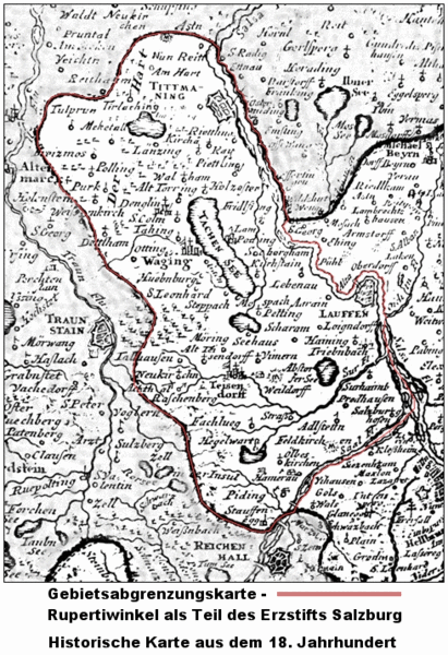
Deutsch: Gebietsabgrenzungskarte -Rupertiwinkel- als Teil des Erzstift Salzburg. Kopie einer historischen Karte des Erzstift Salzburg aus dem 18. Jahrhundert, rot umrandet das Gebiet des Rupertiwinkel. |
| Date | |
| Source | Own work |
| Author | Hans Lauterbach Furchenstein |
| Permission (Reusing this file) |
Deutsch: Die Fotografie wurde mir freundlicherweise von Herrn Andreas Hirsch, Bad Reichenhall, -allgemeinfrei- übergeben. Die Aufnahme wurde im Mai 2010 bei einem Besuch des "Heimathaus des Rupertiwinkel" (Museum) auf der Burg Tittmoning gemacht. |
Licensing[edit]
I, the copyright holder of this work, hereby publish it under the following license:
| This file is made available under the Creative Commons CC0 1.0 Universal Public Domain Dedication. | |
| The person who associated a work with this deed has dedicated the work to the public domain by waiving all of their rights to the work worldwide under copyright law, including all related and neighboring rights, to the extent allowed by law. You can copy, modify, distribute and perform the work, even for commercial purposes, all without asking permission.
|
File history
Click on a date/time to view the file as it appeared at that time.
| Date/Time | Thumbnail | Dimensions | User | Comment | |
|---|---|---|---|---|---|
| current | 13:00, 28 February 2012 | | 490 × 715 (207 KB) | Furchenstein (talk | contribs) | {{Information |Description ={{de|1=Gebietsabgrenzungskarte -Rupertiwinkel- als Teil des Erzstift Salzburg. <br /> Kopie einer historischen Karte des Erzstift Salzburg aus dem 18. Jahrhundert, rot umrandet das Gebiet des Rupertiwinkel. }} |Source ... |
You cannot overwrite this file.
File usage on Commons
There are no pages that use this file.
File usage on other wikis
The following other wikis use this file:
- Usage on de.wikipedia.org