File:RotterdamCentrum.png
Jump to navigation
Jump to search
Size of this preview: 595 × 600 pixels. Other resolutions: 238 × 240 pixels | 476 × 480 pixels | 911 × 918 pixels.
Original file (911 × 918 pixels, file size: 1.17 MB, MIME type: image/png)
Captions
Captions
Add a one-line explanation of what this file represents
| Description |
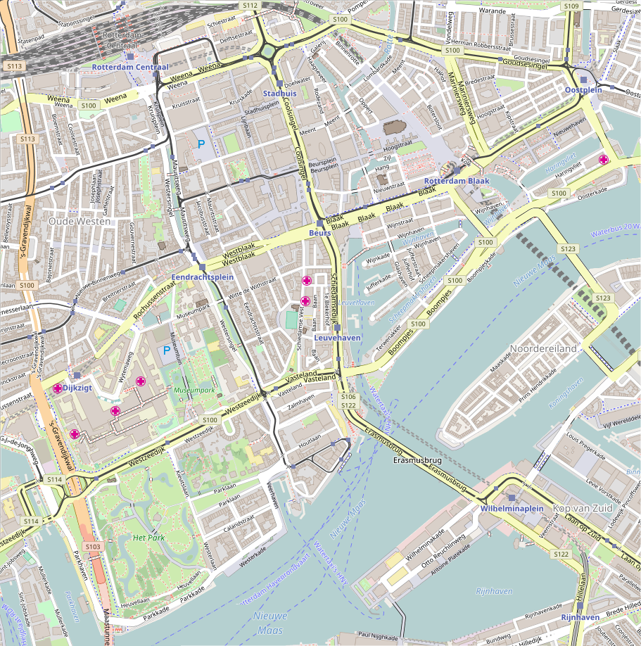
English: Map of Rotterdam
Geographic limits of the map:
This file is licensed under the Creative Commons Attribution-Share Alike 2.0 Generic license.
|
| Date | |
| Source | Maps for Free/OpenStreetMap. Insert is File:Netherlands location map.svg by Lencer |
| Author | Hanhil (talk) 11:58, 16 April 2017 (UTC) |
File history
Click on a date/time to view the file as it appeared at that time.
| Date/Time | Thumbnail | Dimensions | User | Comment | |
|---|---|---|---|---|---|
| current | 11:58, 16 April 2017 | | 911 × 918 (1.17 MB) | Hanhil (talk | contribs) | {{Information |Description={{en|1=Map of Rotterdam Geographic limits of the map: * N: 51.9263° * S: 51.9021° * W: 4.4614° * E: 4.5005° {{CC-BY-SA 2.0}} }} |Source=Maps for Free/OpenStreetMap. Insert is File:Netherlands location map.svg by [... |
You cannot overwrite this file.
File usage on Commons
There are no pages that use this file.
File usage on other wikis
The following other wikis use this file:
- Usage on fr.wikipedia.org
- Usage on fy.wikipedia.org
- Laurentius- en Ignatiuskatedraal (Rotterdam)
- Martlers fan Gorkumtsjerke (Rotterdam)
- Arminiustsjerke (Rotterdam)
- Waalske Tsjerke (Rotterdam)
- Prinsetsjerke (Rotterdam)
- Berjocht:Posysjekaart Rotterdam-Sintrum
- Stasjon Rotterdam Delftsche Poort
- Stasjon Rotterdam Sintraal
- Stasjon Rotterdam Blaak
- Sudertsjerke (Rotterdam)
- Usage on nl.wikipedia.org
- Beurstraverse
- Museum Boijmans Van Beuningen
- Erasmusbrug
- Willemsbrug (Rotterdam)
- De Hef
- Euromast
- Witte Huis (Rotterdam)
- Willemsspoortunnel
- Thalia (Rotterdam)
- Montevideo (gebouw)
- Kubuswoningen (Rotterdam)
- Luchtspoor
- Grote of Sint-Laurenskerk (Rotterdam)
- Erasmus MC
- Delftse Poort (gebouw)
- De verwoeste stad
- Hotel New York (Rotterdam)
- De Doelen
- Coolsingel
- Kunsthal Rotterdam
- Stadhuis van Rotterdam
- De Bijenkorf (Rotterdam)
- Museumpark
- Beurs World Trade Center Rotterdam
- Lijnbaan (Rotterdam)
- Groothandelsgebouw
- Leuvehaven
- Oude Haven (Rotterdam)
- Willemswerf
- Park Schoonoord (Rotterdam)
- Rotterdam Centrum
- Het Schielandshuis
- World Port Center
- 't Leidsche Veem
- Pauluskerk (Rotterdam)
- Millenniumtoren (Rotterdam)
- Haringvliet (Rotterdam)
- Station Rotterdam Delftsche Poort
View more global usage of this file.