File:RogersCrkNorthHayward.gif
Jump to navigation
Jump to search
No higher resolution available.
RogersCrkNorthHayward.gif (640 × 440 pixels, file size: 23 KB, MIME type: image/gif)
Captions
Captions
Add a one-line explanation of what this file represents
| Description |
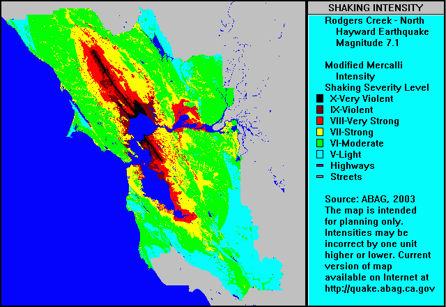
English: ABAG shake map for Rodgers Creek Fault Zone and north Hayward Fault Zone (single event) with colors representing ground motion in the Mercalli Intensity Scale. Note that colors used in the Mercalli article do not correspond to colors used in the ABAG map shown here — use Roman numerals for cross reference. |
| Date | 5 September 2004 (original upload date) |
| Source | Transferred from en.wikipedia to Commons. |
| Author | The original uploader was Leonard G. at English Wikipedia. |
Licensing[edit]
This file is in the public domain because it is a work by or prepared for a tax-supported government agency, the Association of Bay Area Governments (ABAG).
From the ABAG web page [1]:
|
Original upload log[edit]
The original description page was here. All following user names refer to en.wikipedia.
- 2004-09-05 03:57 Leonard G. 640×440× (23379 bytes) ABAG shake map for Rodgers Creek and North Hayward - public domain image
File history
Click on a date/time to view the file as it appeared at that time.
| Date/Time | Thumbnail | Dimensions | User | Comment | |
|---|---|---|---|---|---|
| current | 07:47, 1 May 2009 | | 640 × 440 (23 KB) | Carlog3 (talk | contribs) | {{Information |Description={{en|en:ABAG shake map for en:Rodgers Creek Fault Zone and north en:Hayward Fault Zone (single event) with colors representing ground motion in the en:Mercalli Intensity Scale. Note that colors used in th |
You cannot overwrite this file.
File usage on Commons
There are no pages that use this file.
File usage on other wikis
The following other wikis use this file:
- Usage on de.wikipedia.org
- Usage on en.wikipedia.org
- Usage on en.wikibooks.org
- Usage on en.wiktionary.org
- Usage on fa.wikipedia.org
- Usage on it.wikipedia.org
- Usage on it.wikibooks.org
- Usage on it.wikiversity.org
- Usage on ja.wikipedia.org
Categories:
- Disasters
- Emergency services
- Animations of earthquake impact
- Seismograms
- Maps of Alameda County, California
- Maps of Contra Costa County, California
- Maps of Napa County, California
- Geology of California
- Maps of Solano County, California
- Seismology in the United States
- Seismology in California
- Earthquakes in California
- Hayward Fault