File:Rimrock Draw Rockshelter (28601126962).jpg

Original file (5,472 × 3,648 pixels, file size: 10.69 MB, MIME type: image/jpeg)
Captions
Captions
Summary[edit]
.jpg&action=edit§ion=1)
| Description |
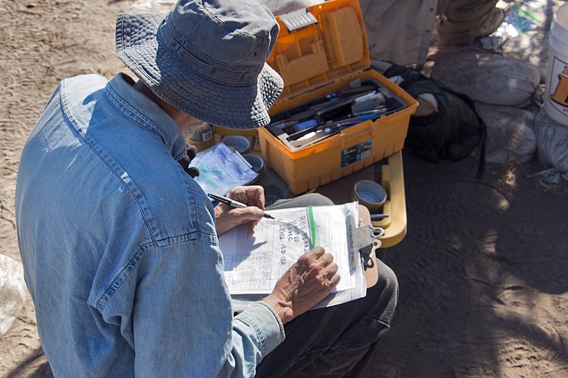
In the summer of 2016, the BLM Burns District continued its partnership with the University of Oregon Museum of Natural and Cultural History and the Oregon Archaeological Society and conducted archaeological excavations at the Rimrock Draw Rockshelter site in southeastern Oregon. The site, discovered in 2009 by BLM Archaeologist Scott Thomas, has hosted archaeology field schools since 2011. In 2015, it became internationally known after archaeologists found a small stone tool under a layer of volcanic ash from a volcanic eruption about 15,800 years ago. This tool suggests one of the oldest known human occupations in the western United States. The 2016 excavations encountered significant rock and boulder debris, resulting from at least two occasions of portions of the rock wall calving or breaking off – probably around 8,000 and 10,000 years ago. These rocks limited access to the ground beneath them, and many were removed only after drilling and splitting reduced them to removeable sizes. In coordination with the BLM’s Scott Thomas, Dr. Patrick O’Grady with the University of Oregon Museum of Natural and Cultural History directed excavations for the fifth year in 2016, and Jordan Pratt, graduate student at Texas A&M University, served as the excavation’s site supervisor. Volunteers from the Oregon Archaeological Society, students from the University of Oregon, and archaeologists from the BLM conducted the excavations. Photo by Greg Shine, BLM |
| Date | |
| Source | Rimrock Draw Rockshelter |
| Author | Bureau of Land Management Oregon and Washington from Portland, America |
Licensing[edit]
.jpg&action=edit§ion=2)
- You are free:
- to share – to copy, distribute and transmit the work
- to remix – to adapt the work
- Under the following conditions:
- attribution – You must give appropriate credit, provide a link to the license, and indicate if changes were made. You may do so in any reasonable manner, but not in any way that suggests the licensor endorses you or your use.
| This image was originally posted to Flickr by BLMOregon at https://flickr.com/photos/50169152@N06/28601126962 (archive). It was reviewed on 13 May 2018 by FlickreviewR 2 and was confirmed to be licensed under the terms of the cc-by-2.0. |
| This image is a work of a Bureau of Land Management* employee, taken or made as part of that person's official duties. As a work of the U.S. federal government, the image is in the public domain in the United States. *or predecessor organization |
| This image is a work of a Bureau of Land Management* employee, taken or made as part of that person's official duties. As a work of the U.S. federal government, the image is in the public domain in the United States. *or predecessor organization |
File history
Click on a date/time to view the file as it appeared at that time.
| Date/Time | Thumbnail | Dimensions | User | Comment | |
|---|---|---|---|---|---|
| current | 15:22, 13 May 2018 | | 5,472 × 3,648 (10.69 MB) | OceanAtoll (talk | contribs) | Transferred from Flickr via #flickr2commons |
You cannot overwrite this file.
File usage on Commons
There are no pages that use this file.
.jpg&oldid=491281395)