File:Riesengebirge 1 zu 75.000.jpg
Jump to navigation
Jump to search

Size of this preview: 574 × 599 pixels. Other resolutions: 230 × 240 pixels | 460 × 480 pixels | 735 × 768 pixels | 980 × 1,024 pixels | 1,961 × 2,048 pixels | 9,253 × 9,664 pixels.
Original file (9,253 × 9,664 pixels, file size: 30.53 MB, MIME type: image/jpeg)
Captions
Captions
Add a one-line explanation of what this file represents
Summary[edit]
| Warning | The original file is very high-resolution. It might not load properly or could cause your browser to freeze when opened at full size. |
|---|
Summary[edit]
| Warning | The original file is very high-resolution. It might not load properly or could cause your browser to freeze when opened at full size. |
|---|
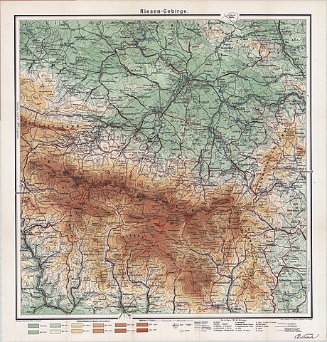
| Title |
Karte des Riesengebirges |
| Date |
before 1901 or circa 1901 At the German Orthographic Conference of 1901 was determined, among other things, to remove in principle the h after t in German words (e.g. Tal instead Thal). |
| Source | Archivkarten von Polen und Mitteleuropa |
| Creator |
Unknown author |
| Geotemporal data | |
| Heading |
 |
| Georeferencing | If inappropriate please set warp_status = skip to hide. |
| Bibliographic data | |
| Language | German |
| Publisher |
Verlag von Alexander Köhler in Dresden |
| Printed by |
Eduard Gäbler´s Geograph. Institut Leipzig |
| Archival data | |
| Dimensions | height: 61.4 cm (24.1 in); width: 58.8 cm (23.1 in) |
| Medium | chromolithograph |
| Other versions |
Krummhübel Schmiedeberg Schneekoppe Riesengebirge vor 1901.jpg |

- Error in {{Map}} template: unknown parameter "1".
Licensing[edit]
|
This is a faithful photographic reproduction of a two-dimensional, public domain work of art. The work of art itself is in the public domain for the following reason:
The official position taken by the Wikimedia Foundation is that "faithful reproductions of two-dimensional public domain works of art are public domain".
This photographic reproduction is therefore also considered to be in the public domain in the United States. In other jurisdictions, re-use of this content may be restricted; see Reuse of PD-Art photographs for details. | ||||
File history
Click on a date/time to view the file as it appeared at that time.
| Date/Time | Thumbnail | Dimensions | User | Comment | |
|---|---|---|---|---|---|
| current | 13:47, 10 July 2016 | | 9,253 × 9,664 (30.53 MB) | MagentaGreen (talk | contribs) | == {{int:filedesc}} == {{LargeImage}} == {{int:description}} == {{InteractiveViewer}} {{Map |title='''Karte des Riesengebirges''' |description= |legend= |author={{unknown|author}} |date={{other date|before|1901}}<br />{{LangSwitch |en=At the German Ort... |
You cannot overwrite this file.
File usage on Commons
The following 2 pages use this file:
.jpg)
File usage on other wikis
The following other wikis use this file:
- Usage on de.wikipedia.org
- Usage on fr.wikipedia.org