File:Regenbogen location map.svg
Jump to navigation
Jump to search

Size of this PNG preview of this SVG file: 424 × 600 pixels. Other resolutions: 170 × 240 pixels | 339 × 480 pixels | 543 × 768 pixels | 724 × 1,024 pixels | 1,448 × 2,048 pixels | 744 × 1,052 pixels.
Original file (SVG file, nominally 744 × 1,052 pixels, file size: 1.92 MB)
Captions
Captions
Add a one-line explanation of what this file represents
Template:Inf:filedesc[edit]
| Description |
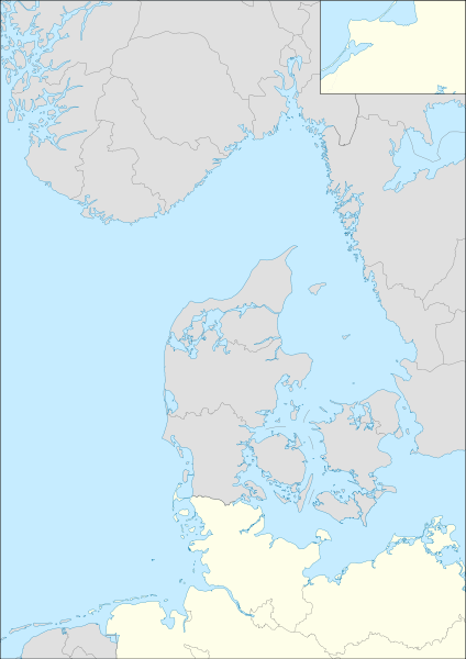
English: Location map for Operation Regenbogen Equirectangular projection. Geographic limits of the map:
|
| Date | (UTC) |
| Source | |
| Author | |
| SVG development |
This file is licensed under the Creative Commons Attribution-Share Alike 3.0 Unported license.
- You are free:
- to share – to copy, distribute and transmit the work
- to remix – to adapt the work
- Under the following conditions:
- attribution – You must give appropriate credit, provide a link to the license, and indicate if changes were made. You may do so in any reasonable manner, but not in any way that suggests the licensor endorses you or your use.
- share alike – If you remix, transform, or build upon the material, you must distribute your contributions under the same or compatible license as the original.
Original upload log[edit]
This image is a derivative work of the following images:
- File:Germany location map.svg licensed with Cc-by-sa-3.0, GFDL
- 2010-01-19T10:03:29Z NordNordWest 1073x1272 (502104 Bytes) update
- 2009-07-22T08:33:33Z NordNordWest 1075x1273 (623082 Bytes) c
- 2008-10-13T14:36:44Z NordNordWest 1075x1273 (620685 Bytes)
- 2008-10-09T21:13:47Z NordNordWest 1075x1273 (627868 Bytes) smaller file, data optimized
- 2008-06-30T20:25:05Z NordNordWest] 1076x1274 (899543 Bytes) {{Information |Description= {{de|Positionskarte von [[:de:Deutschland|Deutschland]]}} Quadratische Plattkarte, N-S-Streckung 150 %. Geographische Begrenzung der Karte: * N: 55.1° N * S: 47.2° N * W: 5.5° O * O: 15.5° O {{
- File:Denmark location map.svg licensed with Cc-by-sa-3.0, GFDL
- 2008-08-25T18:57:20Z NordNordWest 1836x1479 (451991 Bytes) size correction
- 2008-07-02T08:53:40Z NordNordWest 612x493 (444624 Bytes) {{Information |Description= {{de|Positionskarte von [[:de:Dänemark|Dänemark]]}} Quadratische Plattkarte, N-S-Streckung 170 %. Geographische Begrenzung der Karte: * N: 57.9° N * S: 54.3° N * W: 8.8° O * O: 15.4° O {{en|L
- File:Norway location map.svg licensed with Cc-by-sa-3.0, GFDL
- 2008-10-25T20:26:43Z NordNordWest 2215x2353 (2224863 Bytes) corrected
- 2008-08-29T07:56:18Z NordNordWest 2215x2351 (2226297 Bytes)
- 2008-07-28T20:12:55Z NordNordWest 2214x2351 (1894995 Bytes) some corrections
- 2008-07-28T19:47:02Z NordNordWest 2214x2351 (1894765 Bytes) {{Information |Description= {{de|Positionskarte der [[:de:Norwegen|Norwegen]]}} Quadratische Plattkarte, N-S-Streckung 210 %. Geographische Begrenzung der Karte: * N: 71.5° N * S: 57.6° N * W: 4.1° O * O: 31.6° O {{en|Loc
- File:Sweden location map.svg licensed with Cc-by-sa-3.0, GFDL
- 2009-01-27T09:24:12Z Erik Frohne 954x1837 (2870529 Bytes) Added missing border Scania-Blekinge [[Category:Location maps of Sweden]]
- 2008-08-29T08:22:02Z NordNordWest 954x1837 (2868511 Bytes)
- 2008-08-29T08:18:13Z NordNordWest 954x1837 (1529461 Bytes)
- 2008-07-30T11:32:56Z NordNordWest 954x1836 (1527204 Bytes) optimized
- 2008-07-15T18:28:06Z NordNordWest 954x1836 (2123748 Bytes) {{Information |Description= {{de|Positionskarte von [[:de:Schweden|Schweden]]}} Quadratische Plattkarte, N-S-Streckung 190 %. Geographische Begrenzung der Karte: * N: 69.5° N * S: 55.1° N * W: 10.4° O * O: 24.6° O {{en|Lo
- File:Netherlands location map.svg licensed with Cc-by-sa-3.0, GFDL
- 2008-09-11T16:26:25Z Lencer 888x1001 (235175 Bytes) {{Information |Description= |Source= |Date= |Author= |Permission= |other_versions= }}
- 2008-09-10T15:15:26Z Lencer 888x1001 (235195 Bytes) {{Information |Description= |Source= |Date= |Author= |Permission= |other_versions= }}
- 2008-09-09T18:35:56Z Lencer 888x1001 (234406 Bytes) {{Information |Description= |Source= |Date= |Author= |Permission= |other_versions= }}
- 2008-08-16T12:15:18Z Lencer 888x1001 (234098 Bytes) {{Information |Description= |Source= |Date= |Author= |Permission= |other_versions= }}
- 2008-07-24T11:14:56Z NordNordWest 354x399 (218910 Bytes)
- 2008-07-24T11:10:58Z NordNordWest 354x399 (210601 Bytes)
- 2008-07-24T11:03:52Z NordNordWest 354x399 (219496 Bytes)
- 2008-07-24T10:57:42Z NordNordWest 354x399 (129554 Bytes) {{Information |Description= {{de|Positionskarte der [[:de:Niederlande|Niederlande]]}} Quadratische Plattkarte, N-S-Streckung 160 %. Geographische Begrenzung der Karte: * N: 53.7° N * S: 50.6° N * W: 3.1° O * O: 7.5�
Uploaded with derivativeFX
File history
Click on a date/time to view the file as it appeared at that time.
| Date/Time | Thumbnail | Dimensions | User | Comment | |
|---|---|---|---|---|---|
| current | 13:29, 9 May 2010 | | 744 × 1,052 (1.92 MB) | Mike1979 Russia (talk | contribs) | redraw |
| 09:53, 26 April 2010 |  | 744 × 1,052 (2.11 MB) | Mike1979 Russia (talk | contribs) | {{Information |Description={{en|Location map for Operation Regenbogen}} Equirectangular projection. Geographic limits of the map: * N: 61.64° N * S: 52.17° N * W: 4.1° E * E: 15.5° E |Source=*[[:File:Germany_loca |
You cannot overwrite this file.
File usage on Commons
There are no pages that use this file.
File usage on other wikis
The following other wikis use this file:
- Usage on ba.wikipedia.org
- Usage on de.wikipedia.org
- Usage on ru.wikipedia.org