File:Railways Slovakia SK.svg
Jump to navigation
Jump to search

Size of this PNG preview of this SVG file: 800 × 412 pixels. Other resolutions: 320 × 165 pixels | 640 × 330 pixels | 1,024 × 528 pixels | 1,280 × 659 pixels | 2,560 × 1,319 pixels | 2,739 × 1,411 pixels.
Original file (SVG file, nominally 2,739 × 1,411 pixels, file size: 1.09 MB)
Captions
Captions
Add a one-line explanation of what this file represents
Summary[edit]
| Description |
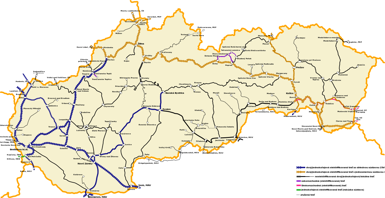
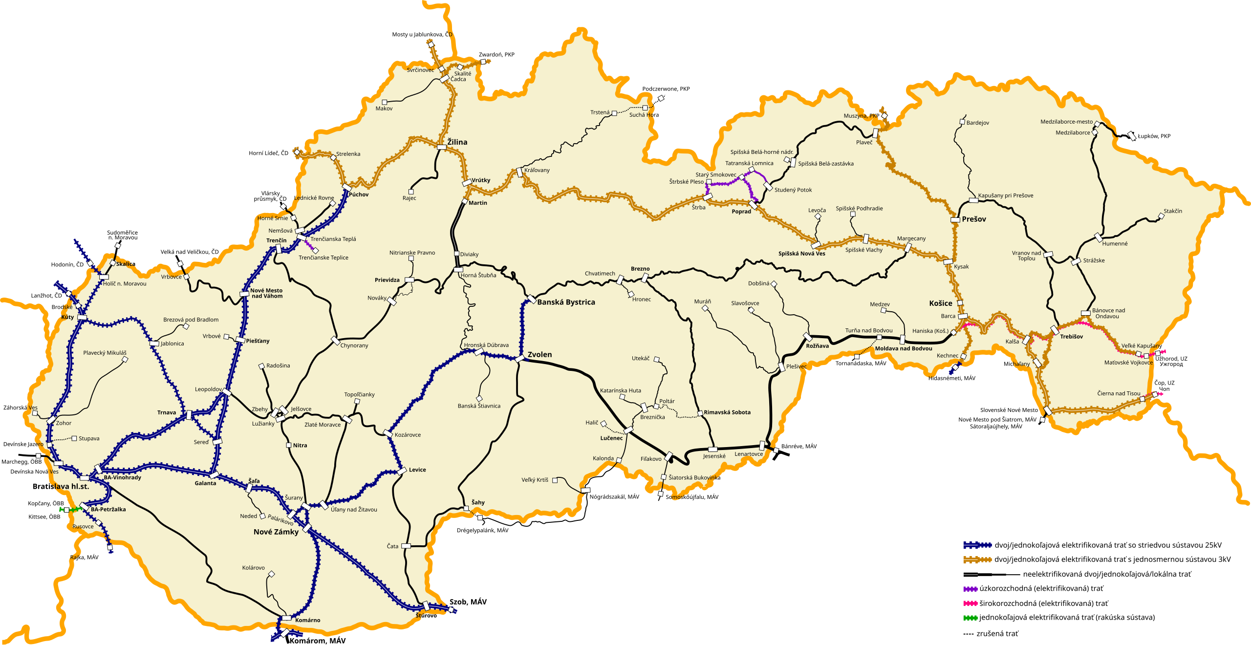
Slovenčina: Mapa železničných tratí na Slovensku (slovenské popisy) English: Map of the railway lines in Slovakia (Slovak description) |
| Date | |
| Source | Own work |
| Author | Poganyp taking into account the style of Magyarország_vasúti_térképe.svg from author Joliet Jake |
| Other versions |
 |
Licensing[edit]
I, the copyright holder of this work, hereby publish it under the following license:
This file is licensed under the Creative Commons Attribution-Share Alike 4.0 International license.
- You are free:
- to share – to copy, distribute and transmit the work
- to remix – to adapt the work
- Under the following conditions:
- attribution – You must give appropriate credit, provide a link to the license, and indicate if changes were made. You may do so in any reasonable manner, but not in any way that suggests the licensor endorses you or your use.
- share alike – If you remix, transform, or build upon the material, you must distribute your contributions under the same or compatible license as the original.
File history
Click on a date/time to view the file as it appeared at that time.
| Date/Time | Thumbnail | Dimensions | User | Comment | |
|---|---|---|---|---|---|
| current | 06:55, 23 April 2015 | | 2,739 × 1,411 (1.09 MB) | Poganyp (talk | contribs) | User created page with UploadWizard |
You cannot overwrite this file.
File usage on Commons
The following 5 pages use this file:
File usage on other wikis
The following other wikis use this file:
- Usage on cs.wikipedia.org
- Usage on de.wikipedia.org
- Usage on el.wikipedia.org
- Usage on en.wikipedia.org
- Usage on nl.wikipedia.org
- Košice (stad in Slowakije)
- Železnice Slovenskej republiky
- Železničná spoločnosť Slovensko
- Spoorlijn Zohor – Plavecký Mikuláš
- Spoorlijn Zohor – Záhorská Ves
- Spoorlijn Kúty – Sudoměřice
- Spoorlijn Kúty – Trnava
- Spoorlijn Jablonica – Brezová pod Bradlom
- Spoorlijn Trenčianska Teplá – Vlársky priesmyk
- Spoorlijn Žilina - Rajec
- Spoorlijn Čadca – Zwardoń
- Spoorlijn Bratislava – Hegyeshalom
- Spoorlijn Galanta – Leopoldov
- Spoorlijn Šaľa – Neded
- Spoorlijn Nové Zámky – Komárom
- Spoorlijn Komárno – Kolárovo
- Spoorlijn Nové Zámky – Prievidza
- Spoorlijn Leopoldov – Kozárovce
- Spoorlijn Zbehy–Radošina
- Spoorlijn Trenčín – Chynorany
- Spoorlijn Prievidza – Nitrianske Pravno
- Spoorlijn Prievidza – Horná Štubňa
- Spoorlijn Nové Zámky – Zlaté Moravce
- Spoorlijn Štúrovo – Levice
- Spoorlijn Zvolen – Čata
- Spoorlijn Hronská Dúbrava – Banská Štiavnica
- Spoorlijn Lučenec – Veľký Krtíš
- Spoorlijn Lučenec - Utekáč
- Spoorlijn Katarínska Huta – Breznička
- Spoorlijn Fiľakovo – Somoskőújfalu
- Spoorlijn Plešivec – Muráň
- Spoorlijn Plešivec – Slavošovce
- Usage on no.wikipedia.org
- Usage on sk.wikipedia.org
- Usage on uk.wikipedia.org