File:Radar of the Quad-State Supercell prior to impacting Mayfield, Kentucky.png
Jump to navigation
Jump to search

Size of this preview: 680 × 600 pixels. Other resolutions: 272 × 240 pixels | 544 × 480 pixels | 871 × 768 pixels | 1,161 × 1,024 pixels | 1,437 × 1,267 pixels.
Original file (1,437 × 1,267 pixels, file size: 1.75 MB, MIME type: image/png)
Captions
Captions
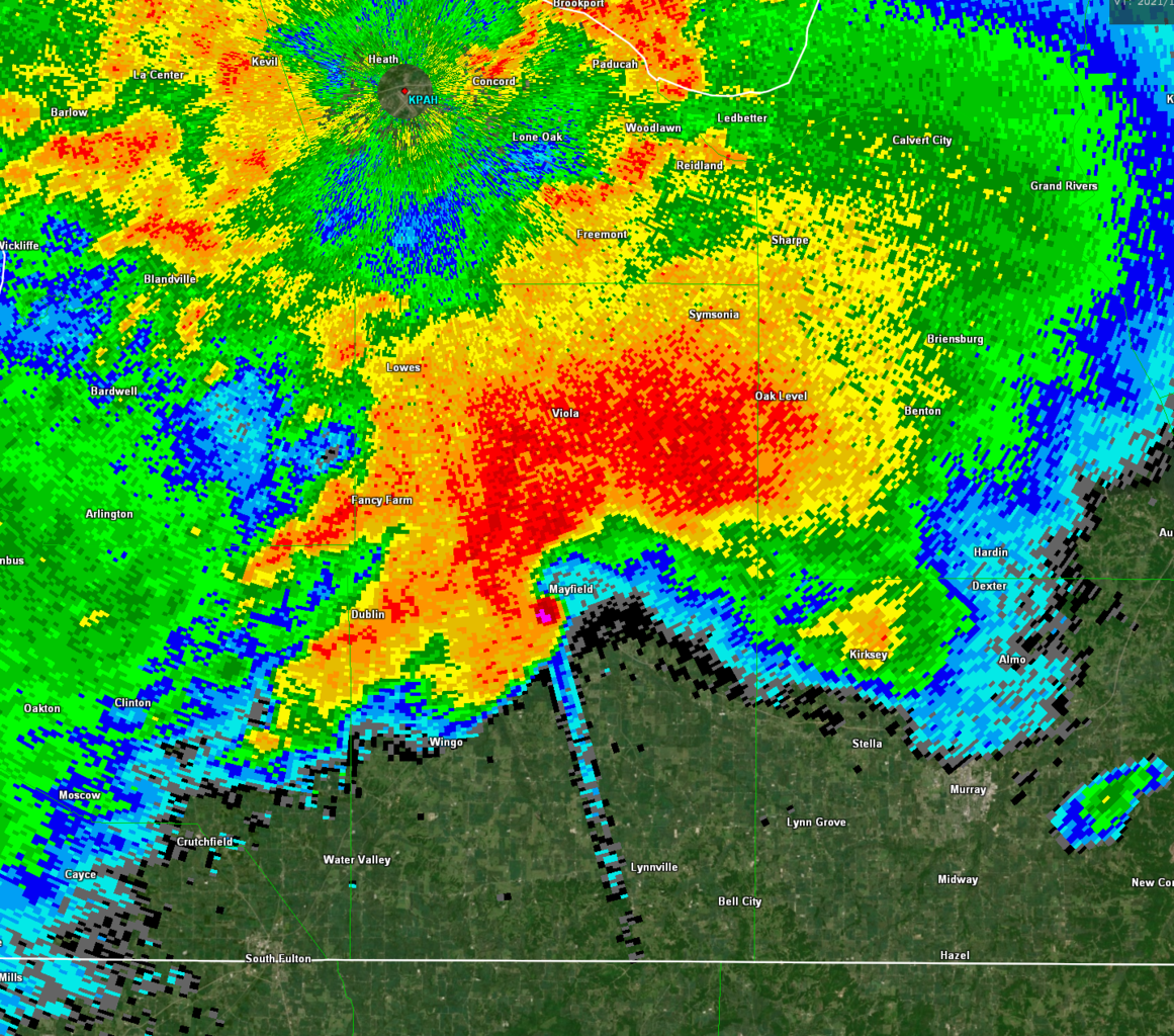
NEXRAD radar of the Quad-State Supercell from KPAH. This is the 2021 Western Kentucky tornado prior to impacting Mayfield, Kentucky.
Summary[edit]
| Description |
English: NEXRAD Reflectivity radar of the Quad-State Supercell from KPAH. This is the 2021 Western Kentucky tornado (seen via the hook echo) prior to impacting the city of Mayfield, Kentucky with winds estimated to be at least 188 miles per hour (303 km/h). The long “line” to the south-southeast is a debris spike caused by debris lofted by the tornado. |
| Date | |
| Source | NEXRAD KPAH |
| Author | National Weather Service |
Licensing[edit]
This image is in the public domain because it is from one or more of the U.S. government’s 159 NEXRAD radars, which are jointly owned and operated by the National Weather Service (NWS), an agency of the National Oceanic and Atmospheric Administration (NOAA) within the United States Department of Commerce, the Federal Aviation Administration (FAA) within the Department of Transportation, and the U.S. Air Force within the Department of Defense.
Thus all NEXRAD images are public domain.
|
  |
File history
Click on a date/time to view the file as it appeared at that time.
| Date/Time | Thumbnail | Dimensions | User | Comment | |
|---|---|---|---|---|---|
| current | 01:51, 2 November 2022 | | 1,437 × 1,267 (1.75 MB) | WeatherWriter (talk | contribs) | Uploaded own work with UploadWizard |
You cannot overwrite this file.
File usage on Commons
There are no pages that use this file.
File usage on other wikis
The following other wikis use this file:
- Usage on de.wikipedia.org
- Usage on en.wikipedia.org