File:Race and ethnicity map of Washington, D.C..png
Jump to navigation
Jump to search
Size of this preview: 487 × 599 pixels. Other resolutions: 195 × 240 pixels | 390 × 480 pixels | 1,011 × 1,244 pixels.
Original file (1,011 × 1,244 pixels, file size: 900 KB, MIME type: image/png)
Captions
Captions
Add a one-line explanation of what this file represents
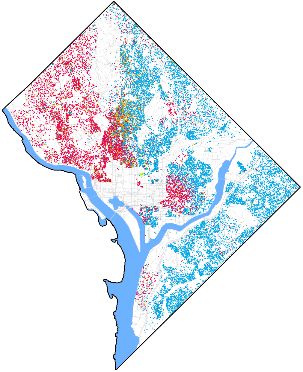
| Description | [Eric Fisher] was astounded by Bill Rankin's map of Chicago's racial and ethnic divides</a> and wanted to see what other cities looked like mapped the same way. To match his map, Red is White, Blue is Black, Green is Asian, Orange is Hispanic, Gray is Other, and each dot is 25 people. Data from Census 2000. Base map © OpenStreetMap, CC-BY-SA |
| Date | (UTC) |
| Source | |
| Author |
|
| Other versions | File:Race and ethnicity in Washington, D.C. 2010.png with 2010 census data |
.png)
| This is a retouched picture, which means that it has been digitally altered from its original version. Modifications: Cropped to District of Columbia, with outline and color for rivers. The original can be viewed here: Race and ethnicity Washington, DC (2000).png:
|
I, the copyright holder of this work, hereby publish it under the following license:
This file is licensed under the Creative Commons Attribution-Share Alike 2.0 Generic license.
- You are free:
- to share – to copy, distribute and transmit the work
- to remix – to adapt the work
- Under the following conditions:
- attribution – You must give appropriate credit, provide a link to the license, and indicate if changes were made. You may do so in any reasonable manner, but not in any way that suggests the licensor endorses you or your use.
- share alike – If you remix, transform, or build upon the material, you must distribute your contributions under the same or compatible license as the original.
Original upload log[edit]
This image is a derivative work of the following images:
- File:Race_and_ethnicity_Washington,_DC_(2000).png licensed with Cc-by-sa-2.0
- 2010-10-16T04:24:53Z Flickr upload bot 3009x3009 (6896026 Bytes) Uploaded from https://flickr.com/photo/24431382@N03/4981417821 using [[User:Flickr upload bot|Flickr upload bot]]
Uploaded with derivativeFX
File history
Click on a date/time to view the file as it appeared at that time.
| Date/Time | Thumbnail | Dimensions | User | Comment | |
|---|---|---|---|---|---|
| current | 00:21, 19 February 2011 | | 1,011 × 1,244 (900 KB) | Patrickneil (talk | contribs) | Columbia Island |
| 00:12, 19 February 2011 |  | 1,011 × 1,244 (896 KB) | Patrickneil (talk | contribs) | river around 14th Street Bridge | |
| 22:40, 18 February 2011 |  | 1,011 × 1,244 (895 KB) | Patrickneil (talk | contribs) | {{Information |Description=[Eric Fisher] was astounded by [http://www.radicalcartography.net/index.html?chicagodots Bill Rankin's] map of Chicago's racial and ethnic divides</a> and wanted to see what other cities looked like mapped the same way. To matc |
You cannot overwrite this file.
File usage on Commons
There are no pages that use this file.
File usage on other wikis
The following other wikis use this file:
- Usage on he.wikivoyage.org