File:RabaulStrategicArea.jpg
Jump to navigation
Jump to search

Size of this preview: 800 × 463 pixels. Other resolutions: 320 × 185 pixels | 640 × 371 pixels | 1,024 × 593 pixels | 1,280 × 741 pixels | 2,500 × 1,448 pixels.
Original file (2,500 × 1,448 pixels, file size: 535 KB, MIME type: image/jpeg)
Captions
Captions
Add a one-line explanation of what this file represents
Summary[edit]
| Description |
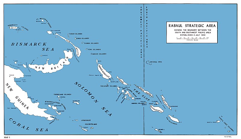
English: U.S. Marine map of SouthWest Pacific area, 1942 |
| Date | |
| Source | [1] [2] Melson, Charles D. (1993). UP THE SLOT: Marines in the Central Solomons. WORLD WAR II COMMEMORATIVE SERIES 36. History and Museums Division, Headquarters, U.S. Marine Corps. Retrieved on Sept 26. |
| Author | Charles D. Melson; Cartographic and visual information: George C. MacGillivray and W. Stephen Hill |
![[1]](http://www.ibiblio.org/hyperwar/USMC/USMC-C-CSol/maps/USMC-C-CSol-1.jpg)
Licensing[edit]
This work is in the public domain in the United States because it is a work prepared by an officer or employee of the United States Government as part of that person’s official duties under the terms of Title 17, Chapter 1, Section 105 of the US Code.
Note: This only applies to original works of the Federal Government and not to the work of any individual U.S. state, territory, commonwealth, county, municipality, or any other subdivision. This template also does not apply to postage stamp designs published by the United States Postal Service since 1978. (See § 313.6(C)(1) of Compendium of U.S. Copyright Office Practices). It also does not apply to certain US coins; see The US Mint Terms of Use.
|
 | |
| This file has been identified as being free of known restrictions under copyright law, including all related and neighboring rights. | ||
File history
Click on a date/time to view the file as it appeared at that time.
| Date/Time | Thumbnail | Dimensions | User | Comment | |
|---|---|---|---|---|---|
| current | 15:09, 5 May 2020 | | 2,500 × 1,448 (535 KB) | Hohum (talk | contribs) | Clearer version |
| 18:28, 14 May 2018 |  | 1,200 × 669 (308 KB) | Hohum (talk | contribs) | Cleanup | |
| 16:16, 27 June 2006 |  | 1,200 × 669 (177 KB) | Cla68 (talk | contribs) | U.S. Marine map of SouthWest Pacific area, 1942. http://www.ibiblio.org/hyperwar/USMC/USMC-C-CSol/index.html. |
You cannot overwrite this file.
File usage on Commons
The following 14 pages use this file:
- Actions along the Matanikau (September – October 1942)
- Battle for Henderson Field
- Battle of Edson's Ridge
- Battle of Rennell Island
- Battle of Savo Island
- Battle of Tulagi and Gavutu-Tanambogo
- Battle of the Coral Sea
- Battle of the Santa Cruz Islands
- Battle of the Tenaru
- Cactus Air Force
- Guadalcanal Campaign
- Invasion of Tulagi (May 1942)
- User:Magog the Ogre/Maps of conflicts/2018 May
- User:Magog the Ogre/Maps of conflicts/2020 May
File usage on other wikis
The following other wikis use this file:
- Usage on ar.wikipedia.org
- Usage on ast.wikipedia.org
- Usage on da.wikipedia.org
- Usage on en.wikipedia.org
- Usage on es.wikipedia.org
- Usage on fr.wikipedia.org
- Usage on he.wikipedia.org
- Usage on hr.wikipedia.org
- Usage on id.wikipedia.org
- Usage on it.wikipedia.org
- Usage on no.wikipedia.org
- Usage on pl.wikipedia.org
- Usage on ru.wikipedia.org
- Usage on sh.wikipedia.org
- Usage on sr.wikipedia.org
- Usage on uk.wikipedia.org
- Usage on zh.wikipedia.org