File:Quttinirpaaq National Park map-fr.svg
Jump to navigation
Jump to search

Size of this PNG preview of this SVG file: 800 × 582 pixels. Other resolutions: 320 × 233 pixels | 640 × 466 pixels | 1,024 × 745 pixels | 1,280 × 932 pixels | 2,560 × 1,863 pixels | 1,800 × 1,310 pixels.
Original file (SVG file, nominally 1,800 × 1,310 pixels, file size: 839 KB)
Captions
Captions
Add a one-line explanation of what this file represents
Summary[edit]
| Camera location | | View this and other nearby images on: OpenStreetMap |
|---|
| Description |
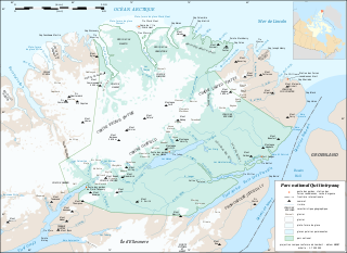
English: Map of Quttinirpaaq National Park, Nunavut, Canada.
Note: Consider using the PNG version which gives a better rendering of the labels on display. Français : Carte du parc national Quttinirpaaq, Nunavut, Canada.
Note : Préférer l'utilisation de la version PNG qui donne un meilleur rendu des textes à l'affichage.
|
||
| Date | |||
| Source |
Own work |
||
| Author | Eric Gaba (Sting - fr:Sting) | ||
| Permission (Reusing this file) |
|
||
| Other versions |
|


|
This SVG file contains embedded text that can be translated into your language, using any capable SVG editor, text editor or the SVG Translate tool. For more information see: About translating SVG files. |
Licensing[edit]
© Eric Gaba, Wikimedia Commons user Sting, the copyright holder of this work, hereby publishes it under the following license:
This file is licensed under the Creative Commons Attribution-Share Alike 3.0 Unported license.
Attribution: © Eric Gaba, Wikimedia Commons user Sting
- You are free:
- to share – to copy, distribute and transmit the work
- to remix – to adapt the work
- Under the following conditions:
- attribution – You must give appropriate credit, provide a link to the license, and indicate if changes were made. You may do so in any reasonable manner, but not in any way that suggests the licensor endorses you or your use.
- share alike – If you remix, transform, or build upon the material, you must distribute your contributions under the same or compatible license as the original.
File history
Click on a date/time to view the file as it appeared at that time.
| Date/Time | Thumbnail | Dimensions | User | Comment | |
|---|---|---|---|---|---|
| current | 14:20, 4 August 2010 | | 1,800 × 1,310 (839 KB) | Sting (talk | contribs) | Ward Hunt Island correction: only bedrock area |
| 18:51, 28 July 2010 |  | 1,800 × 1,310 (840 KB) | Sting (talk | contribs) | Added 3 capes | |
| 23:53, 6 July 2010 |  | 1,800 × 1,310 (837 KB) | Sting (talk | contribs) | Correction for some islands which are in the park | |
| 19:23, 6 July 2010 |  | 1,800 × 1,310 (842 KB) | Sting (talk | contribs) | == {{int:filedesc}} == {{Location|82|00|00|N|72|00|00|W|scale:1000000}} <br/> {{Information |Description={{en|Map of Quttinirpaaq National Park, Nunavut, Canada.<br/>''Note: Consider using |
You cannot overwrite this file.
File usage on Commons
The following 2 pages use this file:
File usage on other wikis
The following other wikis use this file:
- Usage on pl.wikipedia.org
- Usage on ru.wikipedia.org