File:Puy-l'Évêque Grand'Rue1.JPG
Jump to navigation
Jump to search

Size of this preview: 800 × 600 pixels. Other resolutions: 320 × 240 pixels | 640 × 480 pixels | 1,024 × 768 pixels | 1,280 × 960 pixels | 2,560 × 1,920 pixels.
Original file (2,560 × 1,920 pixels, file size: 2.32 MB, MIME type: image/jpeg)
Captions
Captions
Add a one-line explanation of what this file represents
Summary[edit]
| Description |
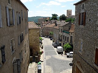
Français : Puy-l’Évêque, commune située dans l’extrême sud-ouest du dép. du Lot (région Midi-Pyrénées, France). Aspect de la Grand'Rue, dans le centre de la localité. Vue prise depuis le pont de la rue Ernest Marcouly. Nous regardons vers le sud. La tour carrée au fond à droite est le donjon, vestige de l'ancien palais épiscopal. |
| Date | |
| Source | Self-photographed |
| Author | Torsade de Pointes |
| Camera location | | View this and other nearby images on: OpenStreetMap |
|---|
Licensing[edit]
| I, the copyright holder of this work, release this work into the public domain. This applies worldwide. In some countries this may not be legally possible; if so: I grant anyone the right to use this work for any purpose, without any conditions, unless such conditions are required by law. |
File history
Click on a date/time to view the file as it appeared at that time.
| Date/Time | Thumbnail | Dimensions | User | Comment | |
|---|---|---|---|---|---|
| current | 21:33, 3 September 2010 | | 2,560 × 1,920 (2.32 MB) | Torsade de Pointes (talk | contribs) | {{Information |Description={{en|1=tcufvygiopkl^m}} |Source=Photographie personnelle |Author=Torsade de Pointes |Date= |Permission= |other_versions= }} |
You cannot overwrite this file.
File usage on Commons
There are no pages that use this file.