File:Puget Sound faults.png
Jump to navigation
Jump to search
Size of this preview: 360 × 600 pixels. Other resolutions: 144 × 240 pixels | 384 × 640 pixels.
Original file (384 × 640 pixels, file size: 612 KB, MIME type: image/png)
Captions
Captions
Add a one-line explanation of what this file represents
Summary[edit]
| Description |
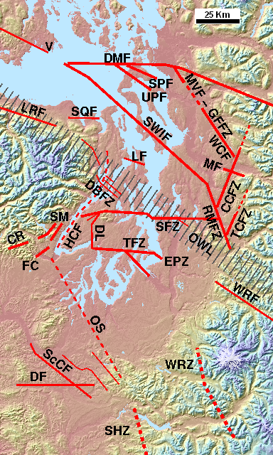
English: The principal w:Puget Sound faults (approximate location of known extents) and other selected peripheral and minor faults. Southern tip of Vancouver Island and San Juan Islands at top left (faults not shown), Olympic Mountains at center left, Mount Rainier at lower right (near WRZ). Faults top right: Devils Mountain, Strawberry Point, Utsalady Point, Mount Vernon, Southern Whidbey Island Fault, Cherry Creek Fault Zone, Tokul Creek Fault Zone, Rattlesnake Mountain Fault Zone. From upper left: Little River, Sequim, Lofall, Dabob Bay Fault Zone, Canyon River, Frigid Creek, Saddle Mountain faults, Hood Canal fault (questioned), Seattle Fault Zone, Dewatto lineament (concealed fault), Tacoma Fault Zone, East Passage Zone, White River (extends east), Olympia Structure, Scammon Creek, Doty (may extend west), Western Rainier Zone, Saint Helens Zone (extends south).
Also shown: part of the Olympic-Wallowa Lineament. Based on sources cited at w:Puget Sound faults. |
| Date | |
| Source | Own work |
| Author | J. Johnson (overlay) and Harvey Greenberg (Univ. of Washington, ESS) (base). |
| Permission (Reusing this file) |
This file is licensed under the Creative Commons Attribution 3.0 Unported license.
|
Licensing[edit]
I, the copyright holder of this work, hereby publish it under the following licenses:
This file is licensed under the Creative Commons Attribution-Share Alike 3.0 Unported license.
- You are free:
- to share – to copy, distribute and transmit the work
- to remix – to adapt the work
- Under the following conditions:
- attribution – You must give appropriate credit, provide a link to the license, and indicate if changes were made. You may do so in any reasonable manner, but not in any way that suggests the licensor endorses you or your use.
- share alike – If you remix, transform, or build upon the material, you must distribute your contributions under the same or compatible license as the original.

|
Permission is granted to copy, distribute and/or modify this document under the terms of the GNU Free Documentation License, Version 1.2 or any later version published by the Free Software Foundation; with no Invariant Sections, no Front-Cover Texts, and no Back-Cover Texts. A copy of the license is included in the section entitled GNU Free Documentation License. |
You may select the license of your choice.
File history
Click on a date/time to view the file as it appeared at that time.
| Date/Time | Thumbnail | Dimensions | User | Comment | |
|---|---|---|---|---|---|
| current | 22:15, 15 October 2017 | | 384 × 640 (612 KB) | J. Johnson (talk | contribs) | Updated and revised faults in the Rogers Belt area, added GFFZ and Monroe fault, per 2016 mapping. |
| 23:30, 26 December 2014 |  | 384 × 640 (678 KB) | J. Johnson (talk | contribs) | Adjusted locations and labels of MVF, LCF/WCF, CCFZ, per latest mapping. | |
| 20:27, 18 December 2014 |  | 384 × 640 (678 KB) | J. Johnson (talk | contribs) | Adjusted Mount Vernon/Chaplain Lake fault and Cherry Creek FZ per latest information from DGER MS 2014-01 (Lake Chaplain). Also adjusted DMF. | |
| 20:56, 19 January 2014 |  | 384 × 640 (676 KB) | J. Johnson (talk | contribs) | Setting to standard size of 384x640 pixels for image map. | |
| 22:50, 18 January 2014 |  | 392 × 670 (731 KB) | J. Johnson (talk | contribs) | Reverted to version as of 00:03, 17 January 2014 -- 18 Jan. image flawed! should be deleted. | |
| 22:30, 18 January 2014 |  | 378 × 640 (671 KB) | J. Johnson (talk | contribs) | Setting up a standard size (for imagemap). | |
| 00:03, 17 January 2014 |  | 392 × 670 (731 KB) | J. Johnson (talk | contribs) | Revised "TF" (Tahuya fault) to "DL" (Dewatto Lineament); removed question mark from MVF; various adjustments of lines and labels, including making WRZ and SHZ look more like "dotted" lines. | |
| 22:47, 31 December 2013 |  | 396 × 670 (739 KB) | J. Johnson (talk | contribs) | Updated to reflect deprecation of Hood Canal fault, addition of Dabob Bay fault zone, and extension of Cherry Creek fault zone, per sources listed in w:Puget Sound faults. | |
| 23:12, 16 January 2013 |  | 394 × 670 (728 KB) | J. Johnson (talk | contribs) | Added Mount Vernon fault (representative of various faults in Rogers Belt), added Tokul Creek fault and clarified position vis-a-vis Cherry Creek Fault Zone, added "V" for Victoria, made several adjustments of position. | |
| 00:15, 18 January 2012 |  | 394 × 669 (674 KB) | J. Johnson (talk | contribs) | Refined positions of some lines, extended RMFZ per DGER 2011-1 (Dragovich, et al.). |
You cannot overwrite this file.
File usage on Commons
There are no pages that use this file.
File usage on other wikis
The following other wikis use this file:
- Usage on de.wikipedia.org
- Usage on en.wikipedia.org