File:Public transport in Zavodski district (Minsk, Belarus) — Общественный транспорт в Заводском районе (Минск, Беларусь).png
Jump to navigation
Jump to search
Size of this preview: 759 × 599 pixels. Other resolutions: 304 × 240 pixels | 608 × 480 pixels | 973 × 768 pixels | 1,280 × 1,011 pixels | 1,941 × 1,533 pixels.
Original file (1,941 × 1,533 pixels, file size: 3.15 MB, MIME type: image/png)
Captions
Captions
Add a one-line explanation of what this file represents
Summary
[edit]_%E2%80%94_%D0%9E%D0%B1%D1%89%D0%B5%D1%81%D1%82%D0%B2%D0%B5%D0%BD%D0%BD%D1%8B%D0%B9_%D1%82%D1%80%D0%B0%D0%BD%D1%81%D0%BF%D0%BE%D1%80%D1%82_%D0%B2_%D0%97%D0%B0%D0%B2%D0%BE%D0%B4%D1%81%D0%BA%D0%BE%D0%BC_%D1%80%D0%B0%D0%B9%D0%BE%D0%BD%D0%B5_(%D0%9C%D0%B8%D0%BD%D1%81%D0%BA,_%D0%91%D0%B5%D0%BB%D0%B0%D1%80%D1%83%D1%81%D1%8C).png&action=edit§ion=1)
| Description |
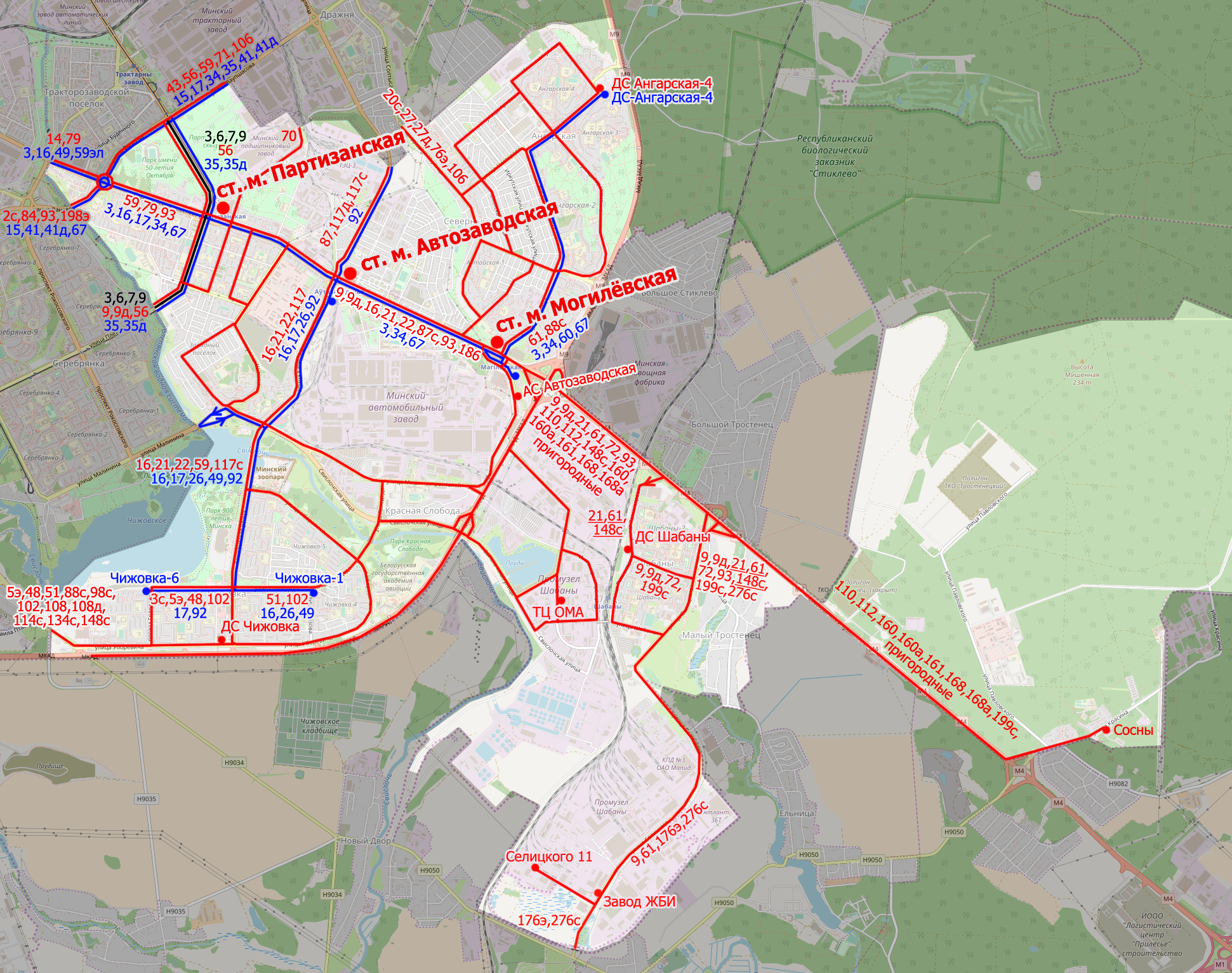
English: Public transport in Zavodski district (Minsk, Belarus). Buses and metro are in red, trolleybuses are in blue, trams are in black.
Русский: Общественный транспорт в Заводском районе (Минск, Беларусь). Автобусы и станции метрополитена подписаны красным цветом, троллейбусы — синим, трамваи — чёрным. |
| Date | |
| Source | Own work, using OpenStreetMap as a basis |
| Author | Homoatrox (transport), OpenStreetMap authors (original map) |
Licensing
[edit]_%E2%80%94_%D0%9E%D0%B1%D1%89%D0%B5%D1%81%D1%82%D0%B2%D0%B5%D0%BD%D0%BD%D1%8B%D0%B9_%D1%82%D1%80%D0%B0%D0%BD%D1%81%D0%BF%D0%BE%D1%80%D1%82_%D0%B2_%D0%97%D0%B0%D0%B2%D0%BE%D0%B4%D1%81%D0%BA%D0%BE%D0%BC_%D1%80%D0%B0%D0%B9%D0%BE%D0%BD%D0%B5_(%D0%9C%D0%B8%D0%BD%D1%81%D0%BA,_%D0%91%D0%B5%D0%BB%D0%B0%D1%80%D1%83%D1%81%D1%8C).png&action=edit§ion=2)
I, the copyright holder of this work, hereby publish it under the following license:
This file is licensed under the Creative Commons Attribution-Share Alike 4.0 International license.
- You are free:
- to share – to copy, distribute and transmit the work
- to remix – to adapt the work
- Under the following conditions:
- attribution – You must give appropriate credit, provide a link to the license, and indicate if changes were made. You may do so in any reasonable manner, but not in any way that suggests the licensor endorses you or your use.
- share alike – If you remix, transform, or build upon the material, you must distribute your contributions under the same or compatible license as the original.
| Description |
This map was created from OpenStreetMap project data, collected by the community. This map may be incomplete, and may contain errors. Don't rely solely on it for navigation. |
|||
| Date | (see file history) | |||
| Source | openstreetmap.org | |||
| Creator |
OpenStreetMap contributors |
|||
| Permission (Reusing this file) |
OpenStreetMap data is available under the Open Database License (details). Map tiles are licensed under the Creative Commons Attribution-ShareAlike 2.0 license (CC-BY-SA 2.0).
This file is licensed under the Creative Commons Attribution-Share Alike 2.0 Generic license.
|
|||
| Georeferencing | If inappropriate please set warp_status = skip to hide. |
File history
Click on a date/time to view the file as it appeared at that time.
| Date/Time | Thumbnail | Dimensions | User | Comment | |
|---|---|---|---|---|---|
| current | 11:44, 9 November 2018 | | 1,941 × 1,533 (3.15 MB) | Homoatrox (talk | contribs) | User created page with UploadWizard |
You cannot overwrite this file.
File usage on Commons
The following 4 pages use this file:
File usage on other wikis
The following other wikis use this file:
- Usage on ru.wikipedia.org
_—_Общественный_транспорт_в_Заводском_районе_(Минск,_Беларусь).png&oldid=808377802)